Union Vale, New York
Union Vale is a town in Dutchess County, New York, United States. The population was 4,877 at the 2010 census.[3]
Union Vale, New York | |
|---|---|
Town | |
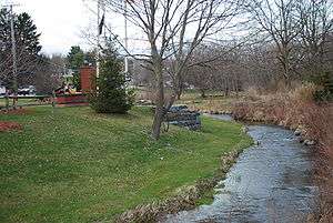 Sprout Creek in Verbank | |
 Seal | |
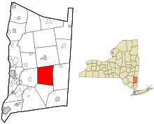 Location of Union Vale, New York | |
| Coordinates: 41°41′53″N 73°41′57″W | |
| Country | United States |
| State | New York |
| County | Dutchess |
| Established | 1827 |
| Government | |
| • Type | Town Council |
| • Town Supervisor | Betsy Maas (R) |
| • Town Council | Members' List
|
| Area | |
| • Total | 37.81 sq mi (97.92 km2) |
| • Land | 37.48 sq mi (97.08 km2) |
| • Water | 0.32 sq mi (0.84 km2) |
| Elevation | 495 ft (151 m) |
| Population (2010) | |
| • Total | 4,877 |
| • Estimate (2016)[2] | 4,809 |
| • Density | 128.30/sq mi (49.54/km2) |
| Time zone | UTC-5 (Eastern (EST)) |
| • Summer (DST) | UTC-4 (EDT) |
| FIPS code | 36-027-76166 |
| GNIS feature ID | 0979573 |
| Website | unionvaleny |
The town is in the south-central part of the county. It is part of the Poughkeepsie–Newburgh–Middletown, NY Metropolitan Statistical Area as well as the larger New York–Newark–Bridgeport, NY-NJ-CT-PA Combined Statistical Area. The town is 15 miles (24 km) east of the city of Poughkeepsie and 70 miles (110 km) north of New York City.
History
The region was originally part of the Beekman Patent. The town was first settled around 1716, and was formed in 1827 from the towns of Beekman and LaGrange.
Geography
According to the United States Census Bureau, the town of Union Vale has a total area of 37.8 square miles (97.9 km2), of which 37.5 square miles (97.1 km2) is land and 0.31 square miles (0.8 km2), or 0.86%, is water.[3] The highest point is atop Clove Mountain, at 1,400 feet (430 m) above sea level.
New York State Route 55 runs through the southwestern part of the town.
Sky Acres Airport, a general aviation facility, is located in the northwestern part of the town.[4]
Parks and recreation
Union Vale has two town parks, Tymor Park and Frederick E. Godfrey Memorial Park.
The larger park is Tymor Park which is nearly 500 acres (2.0 km2) and is the largest municipal park in the state of New York.[5] It has various recreational facilities such as sports fields, an outdoor pool, playground, pavilions, concession stand, a senior center, rental halls, equestrian center, camping areas, a fishing pond, ice rinks in the winter, tennis courts, basketball courts, volleyball courts, historical sites, and over 12 miles (19 km) of hiking/biking/equestrian trails.
Frederick E. Godfrey Memorial Park (Godfrey Park) is 12 acres (49,000 m2) and includes hiking trails, a playground, basketball court, volleyball court, restrooms, and a baseball/softball field.
There is a private golf course, The Links at Union Vale, on the western side of the town.[6]
Demographics
| Historical population | |||
|---|---|---|---|
| Census | Pop. | %± | |
| 1830 | 1,833 | — | |
| 1840 | 1,498 | −18.3% | |
| 1850 | 1,552 | 3.6% | |
| 1860 | 1,502 | −3.2% | |
| 1870 | 1,434 | −4.5% | |
| 1880 | 1,407 | −1.9% | |
| 1890 | 1,033 | −26.6% | |
| 1900 | 945 | −8.5% | |
| 1910 | 1,097 | 16.1% | |
| 1920 | 987 | −10.0% | |
| 1930 | 1,025 | 3.9% | |
| 1940 | 1,056 | 3.0% | |
| 1950 | 970 | −8.1% | |
| 1960 | 1,138 | 17.3% | |
| 1970 | 1,702 | 49.6% | |
| 1980 | 2,658 | 56.2% | |
| 1990 | 3,577 | 34.6% | |
| 2000 | 4,546 | 27.1% | |
| 2010 | 4,877 | 7.3% | |
| Est. 2016 | 4,809 | [2] | −1.4% |
| U.S. Decennial Census[7] | |||
As of the census[8] of 2000, there were 4,546 people, 1,359 households, and 1,141 families residing in the town. The population density was 120.6 people per square mile (46.6/km²). There were 1,464 housing units at an average density of 38.8 per square mile (15.0/km²). The racial makeup of the town was 94.24% white, 2.35% African American, 0.11% Native American, 1.19% Asian, 0.04% Pacific Islander, 1.03% from other races, and 1.03% from two or more races. Hispanic or Latino of any race were 3.43% of the population.
There were 1,359 households out of which 47.0% had children under the age of 18 living with them, 75.9% were married couples living together, 5.6% had a female householder with no husband present, and 16.0% were non-families. 12.9% of all households were made up of individuals and 4.9% had someone living alone who was 65 years of age or older. The average household size was 3.10 and the average family size was 3.40.
In the town, the population was spread out with 28.9% under the age of 18, 5.5% from 18 to 24, 30.1% from 25 to 44, 25.6% from 45 to 64, and 9.9% who were 65 years of age or older. The median age was 38 years. For every 100 females, there were 100.7 males. For every 100 females age 18 and over, there were 100.3 males.
The median income for a household in the town was $70,500, and the median income for a family was $72,697. Males had a median income of $51,382 versus $29,643 for females. The per capita income for the town was $24,535. About 0.8% of families and 2.9% of the population were below the poverty line, including 1.7% of those under age 18 and none of those age 65 or over.
Communities and locations in Union Vale
- Camby – A location in the northeast part of the town.
- Chestnut Ridge – A location at the east town line.
- Clove – A hamlet near the town center.
- Clove Mountain – An elevation west of Clove village.
- Crouses Store – A location in the southwest part of the town.
- LaGrangeville or (La Grangeville) – A hamlet in the southwestern corner of the town that Union Vale shares with the towns of LaGrange and Beekman. With the zip code of 12540.
- Hoxie Corner – A location southwest of Verbank.
- North Clove – A location northeast of Clove.
- Pleasant Ridge – A location in the southeast part of the town.
- Verbank – A hamlet near the north town line.
- Verbank Village – A hamlet west of Verbank.
Oswego
Oswego is a former hamlet, later a ghost town, in the northwestern part of the town, north of Lagrangeville and south of Verbank, now part of the hamlet of Moores Mills, shared with the town of LaGrange. It is located directly southeast of Sky Acres airport. A historic marker set by the state government marks the spot of the former hamlet. The Oswego Meeting House and Friends' Cemetery was listed on the National Register of Historic Places in 1989.[9][10]
This ghost town shares a name with a city in the northern part of the state, also named Oswego, New York.
References
- "2016 U.S. Gazetteer Files". United States Census Bureau. Retrieved Jul 4, 2017.
- "Population and Housing Unit Estimates". Retrieved June 9, 2017.
- "Geographic Identifiers: 2010 Demographic Profile Data (G001): Union Vale town, Dutchess County, New York". U.S. Census Bureau, American Factfinder. Archived from the original on February 13, 2020. Retrieved November 16, 2015.
- Sky Acres Aireport website. Accessed July 22, 2013.
- "TOWN OF UNION VALE IS FIRST TO PASS A POLLINATOR PROTECTION POLICY IN DUTCHESS COUNTY, NY". The Harlem Valley News. Retrieved 3 January 2018.
- The Links at Union Vale website. Accessed July 22, 2013.
- "Census of Population and Housing". Census.gov. Retrieved June 4, 2015.
- "U.S. Census website". United States Census Bureau. Retrieved 2008-01-31.
- "National Register Information System". National Register of Historic Places. National Park Service. March 13, 2009.
- Oswego Meeting House And Friends' Cemetery in Moore's Mill at the Historic Places website. Accessed July 22, 2013.
External links
Municipalities and communities of Dutchess County, New York, United States | ||
|---|---|---|
| Cities |  | |
| Towns | ||
| Villages | ||
| CDPs |
| |
| Other hamlets | ||
| Former communities | ||
| Footnotes | ‡This populated place also has portions in an adjacent county or counties | |