Merritt Park, New York
Merritt Park is a census-designated place (CDP) in the town of Fishkill, New York.[1] As of the 2010 census it had a population of 1,256.[2]
Merritt Park, New York | |
|---|---|
 Location of Merritt Park, New York | |
| Coordinates: 41°32′19″N 73°52′21″W | |
| Country | United States |
| State | New York |
| County | Dutchess |
| Town | Fishkill |
| Area | |
| • Total | 0.44 sq mi (1.15 km2) |
| • Land | 0.44 sq mi (1.15 km2) |
| • Water | 0.0 sq mi (0.0 km2) |
| Elevation | 285 ft (87 m) |
| Population (2010) | |
| • Total | 1,256 |
| • Density | 2,828/sq mi (1,091.9/km2) |
| Time zone | UTC-5 (Eastern (EST)) |
| • Summer (DST) | UTC-4 (EDT) |
| Area code(s) | 845 |
| FIPS code | 36-46750 |
| GNIS feature ID | 2584278 |
The CDP is located in the eastern part of the town of Fishkill in southwestern Dutchess County. It is bordered to the west by the village of Fishkill, to the north by Fishkill Creek, to the southeast by 904-foot (276 m) Honness Mountain, and to the northeast by New York State Route 52. Merritt Boulevard is the main thoroughfare through the community, connecting NY 52 to the northeast with U.S. Route 9 in the southern part of Fishkill village.
According to the U.S. Census Bureau, the Merritt Park CDP has a total area of 0.44 square miles (1.15 km2), all of it land.[2]
References
- U.S. Geological Survey Geographic Names Information System: Merritt Park, New York
- "Geographic Identifiers: 2010 Demographic Profile Data (G001): Merritt Park CDP, New York". U.S. Census Bureau, American Factfinder. Archived from the original on February 13, 2020. Retrieved November 19, 2015.
Municipalities and communities of Dutchess County, New York, United States | ||
|---|---|---|
| Cities | 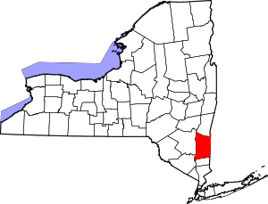 | |
| Towns | ||
| Villages | ||
| CDPs |
| |
| Other hamlets | ||
| Former communities | ||
| Footnotes | ‡This populated place also has portions in an adjacent county or counties | |
This article is issued from Wikipedia. The text is licensed under Creative Commons - Attribution - Sharealike. Additional terms may apply for the media files.