Red Hook, New York
Red Hook is a town in Dutchess County, New York, United States. The population was 11,319 at the time of the 2010 census.[3] The name is supposedly derived from the red foliage on trees on a small strip of land on the Hudson River. The town contains two villages, Red Hook and Tivoli. The town is in the northwest part of Dutchess County. U.S. Route 9 and State Route 9G pass through the town.
Red Hook, New York | |
|---|---|
Town | |
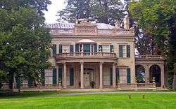 Montgomery Place in Barrytown | |
 Flag  Seal | |
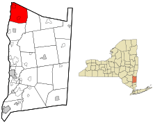 Location of Red Hook, New York | |
| Coordinates: 42°0′46″N 73°53′15″W | |
| Country | United States |
| State | New York |
| County | Dutchess |
| Established | 1812 |
| Government | |
| • Type | Town Council |
| • Town Supervisor | Robert McKeon (D) |
| • Town Council | Members' List
|
| Area | |
| • Total | 40.04 sq mi (103.70 km2) |
| • Land | 36.17 sq mi (93.68 km2) |
| • Water | 3.87 sq mi (10.03 km2) |
| Elevation | 203 ft (62 m) |
| Population (2010) | |
| • Total | 11,319 |
| • Estimate (2016)[2] | 11,181 |
| • Density | 309.13/sq mi (119.36/km2) |
| Time zone | UTC−5 (Eastern (EST)) |
| • Summer (DST) | UTC−4 (EDT) |
| ZIP Codes | 12504, 12507, 12571 |
| Area code(s) | 845 |
| FIPS code | 36-027-60905 |
| GNIS feature ID | 0979411 |
| Website | redhook |
The town also contains two hamlets. Bard College is in the hamlet of Annandale-on-Hudson. The Unification Theological Seminary is in the hamlet of Barrytown. Both hamlets are located within the Hudson River Historic District.
History
The original inhabitants of this land were the Mohican, Munsee and Lenape people.[4][5] During European settlement, Native American tribes played a fundamental role in the area's economy as they traded beaver skin with European settlers.[6] European settlers imported several foreign goods, such as cattle, horses, and sheep. Enslaved African American individuals were also brought.[7] Through importing non-native species, the landscape and ecology of this region has been dramatically changed.[8]
European settler-colonial understandings of land-ownership are different from the perspectives of Mohican, Munsee and Lenape land use, a difference not often reflected in the land deeds that establish European presence on this land. The Lenape believed that Kishelëmukòng had created the earth for all people and creatures, meaning that land could not be appropriated by any individual or despoiled for personal profit. In this way, this group of people did not understand the process of selling land but believed they would receive continued access to it to hunt, fish, forage, or even plant crops.[9] Through Schuyler's Patent, English settler Peter Schuyler acquired two tracts of land from unidentified native peoples, “one near Red Hook and one south of Poughkeepsie” in 1688.[7] One of the three place-names identified in Schuyler's Patent is given in the Munsee language.[10]
Prior to 1812, Red Hook was part of the town of Rhinebeck. Because Rhinebeck, as well other towns, had populations over 5,000 residents, the state legislature authorized the separation of these two precincts on June 12 to accommodate and encourage public attendance at town meetings via horseback or carriage. The first documented Town of Red Hook meeting was on April 6, 1813, in a local inn and held yearly afterwards as required by law. Wealthy landowning farmers oversaw the maintenance of their assigned roads with the help of their farm workers and neighbors. The Red Hook Society for the Apprehension and Detention of Horse Thieves is thought to be one of the oldest formal organizations in the state and still holds an annual meeting.
Geography
Prior to European settlement, the land surrounding the Mahicannituck, or the Hudson River, included “forested hills, meadows, and tributary streams”.[11] This landscape of the river, as well as the surrounding land, was often portrayed in a romanticized, naturalized fashion to depict an American “wilderness” that was devoid of Indigenous presence to further narratives of European exploration of the Americas.[12] This same landscape was described in small detail in Hendrick Aupaumut’s written account of the Native history of the Mohicans in 1791, showing that Native people enjoyed this same landscape prior to these settlers’ arrival.[13] Upon their arrival, settlers changed this landscape through the building of grist mills, sawmills, a carding machine, a trip hammer, and a distillery in 1797.[7] Other more contemporary examples of the change in the geography of the town of Redhook include the development of Tivoli North Bay and Stony Creek watershed as well as the Tivoli South Bay and the Saw Kill watershed.[14] European settlement did not always cause environmental change but it may or may not have altered the rate at which environmental change naturally occurs.[15]
The Stockbridge-Munsee Band of Mohicans have identified Dutchess County, which includes Red Hook, as an area of archeological interest.[16]
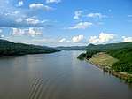
According to the United States Census Bureau, the town currently has a total area of 40.0 square miles (103.7 km2), of which 36.2 square miles (93.7 km2) is land and 3.9 square miles (10.0 km2), or 9.67%, is water.[3] The north town line is the border of Columbia County. The west town line is the border of Ulster County and is defined by center of the Hudson River.
Education
The town of Red Hook has its own school district (which also includes part of the neighboring towns of Milan and Livingston).[17] Over 700 students are enrolled in the high school.[18] Enrollment in the elementary and middle schools is growing each year. Grades pre-kindergarten to five attend the Mill Road Elementary School, grades 6–8 attend the Linden Avenue Middle School, and grades 9–12 attend the Red Hook High School.
In sports, Red Hook High School is ranked Class A in soccer, basketball, softball and baseball as well as Class B in all other sports. It is located in the Section 9 district. In 2006, Red Hook's varsity volleyball team won the Mid-Hudson Athletic League, and Section IX championships. That same year, the team participated in the NYSPHSAA state championships, finishing in third place in the class B division. In 2007, the team were once again Mid-Hudson Athletic League champions and Section IX champions, this time finishing in second at the NYSPHAA state championships. In 2008, 2009, 2010, 2011, 2012, and 2013 the Red Hook Boy's Varsity Lacrosse Team won the Section IX Championship six times in a row, earning six titles in seven years, since the program's creation. However, the school is primarily known for its basketball program and has consistently won sectional titles and contended for state championships. In addition, the Red Hook Robotics Team (FIRST Tech Challenge Team 6567 Red Hook RoboRaiders) has existed since 2012 and recently competed at the FIRST Tech Challenge World Championships in St. Louis, MO in May 2017. Red Hook High School was ranked at #280 among the thousands of high schools across the country by Newsweek. Over 80% of its graduates go on to two and four year colleges.[18]
| School | Grades |
| Mill Road Elementary School | K to 5th |
| Linden Avenue Middle School | 6th to 8th |
| Red Hook High School | 9th to 12th |
Demographics (2010)
| Historical population | |||
|---|---|---|---|
| Census | Pop. | %± | |
| 1820 | 2,714 | — | |
| 1830 | 2,983 | 9.9% | |
| 1840 | 2,829 | −5.2% | |
| 1850 | 3,264 | 15.4% | |
| 1860 | 3,964 | 21.4% | |
| 1870 | 4,350 | 9.7% | |
| 1880 | 4,471 | 2.8% | |
| 1890 | 4,388 | −1.9% | |
| 1900 | 3,895 | −11.2% | |
| 1910 | 3,705 | −4.9% | |
| 1920 | 3,218 | −13.1% | |
| 1930 | 3,404 | 5.8% | |
| 1940 | 3,405 | 0.0% | |
| 1950 | 4,219 | 23.9% | |
| 1960 | 6,023 | 42.8% | |
| 1970 | 7,548 | 25.3% | |
| 1980 | 8,351 | 10.6% | |
| 1990 | 9,565 | 14.5% | |
| 2000 | 10,408 | 8.8% | |
| 2010 | 11,319 | 8.8% | |
| Est. 2016 | 11,181 | [2] | −1.2% |
| U.S. Decennial Census[19] | |||
As of the census[20] of 2010, there were 11,149 people, 3,851 households, and 2,473 families residing in the town. The population density was 283.6 people per square mile (109.5/km²). There were 3,851 housing units at an average density of 104.6 per square mile (40.4/km²). The racial makeup of the town was 90.10% White, 1.44% African American, 0.50% Native American, 3.30% Asian, 0.00% Pacific Islander, 0.65% from other races, and 1.60% from two or more races. Hispanic or Latino of any race were 6.70% of the population.
There were 3,851 households. 18.4% were children under the age of 18, 56.5% were married couples living together, 9.3% had a female householder with no husband present, and 30.8% were non-families. Of all households 23.4% were made up of individuals and 9.1% had someone living alone who was 65 years of age or older. The average household size was 2.63 and the average family size was 3.14.
In the town, the population was spread out with 18.4% under the age of 18, 15.0% from 18 to 24, 25.8% from 25 to 44, 22.6% from 45 to 64, and 16.0% who were 65 years of age or older. The median age was 36 years. For every 100 females, there were 94.5 males. For every 100 females age 18 and over, there were 89.0 males. The percentage of female persons was 51.3%.
The median income for a household in the town was $46,701, and the median income for a family was $57,950. Males had a median income of $42,099 versus $26,694 for females. The per capita income for the town was $20,410. About 5.0% of families and 8.7% of the population were below the poverty line, including 7.8% of those under age 18 and 5.2% of those age 65 or over.
Communities and locations in the Town of Red Hook

- Annandale-on-Hudson: A hamlet in the northwest part of the town by the Hudson River. Because this community does not have a well-developed business district, students of Bard College often use the Villages of Tivoli and downtown Red Hook as "college towns".
- Bard College: A college located in the northwest part of the town, which was listed as a CDP in 2020.
- Barrytown: A hamlet south of Annandale-on-Hudson. The north junction of NY 9G and NY 199 is known as Barrytown Corners.
- Cokertown: A hamlet in the northeast part of the town, located on County Route 56.
- College Park: A housing development east of Bard College.
- Forest Park: A housing development in the south part of the town.
- Fraleighs: A hamlet in the eastern part of the town.
- Kerleys Corners: A hamlet near the north town line at the junction of US 9 and County Route 78.
- Linden Acres: A housing development northwest of Red Hook village.
- Red Hook: The Village of Red Hook.
- Red Hook Mills: A hamlet north of Red Hook village.
- Spring Lakes: A small hamlet along County Route 55.
- Tivoli: The Village of Tivoli is in the northwest part of the town by the Hudson River. The West side of NY 9G is Tivoli, while the east is still considered the town of Red Hook.
- Upper Red Hook: A hamlet north of Red Hook village.
Transportation
Airport
Sky Park Airport is a public use general aviation facility located two nautical miles (4 km) east of Red Hook's central business district.[21] Sky Park Airport is no longer in service.
Roads
U.S Route 9 runs north south through Red Hook. New York State Route 199 runs east west and passes to he west over the Hudson River towards Kingston, New York.
Sports
- Kyle Murphy, professional soccer player, San Antonio F.C.
- Red Hook Heatwave Soccer, 2017 ENYYSA State Cup winners, 2016–2017 ENYYSA Premier League Champions.
Notable people
.jpg)

- Hannah Arendt, philosopher and author
- Egbert Benson, first New York Attorney General
- Lewis Combs, United States admiral
- Dorothy Day, founder of the Catholic Worker Movement
- Louis Diaz, undercover DEA agent and actor
- Gary Hill, video artist
- George E. Jonas, industrialist and founder of Camp Rising Sun, an international scholarship summer leadership program
- Alison Knowles, artist active in the Fluxus movement
- Brice Marden, noted abstract painter and printmaker
- Joseph G. Masten, mayor of Buffalo, 1843–1844 and 1845–1846[22]
- John Morris, film and TV composer.
- Peter Serkin, classical pianist.
- Robert Sheckley, science fiction writer[23]
- William B. Sheldon, Wisconsin territorial legislator and lawyer
- Gore Vidal, writer and public intellectual
- Kyle Murphy, professional soccer player
See also
- Poets' Walk Park
References
- "2016 U.S. Gazetteer Files". United States Census Bureau. Retrieved Jul 4, 2017.
- "Population and Housing Unit Estimates". Retrieved June 9, 2017.
- "Geographic Identifiers: 2010 Demographic Profile Data (G001): Red Hook town, Dutchess County, New York". U.S. Census Bureau, American Factfinder. Archived from the original on February 13, 2020. Retrieved November 16, 2015.
- "Origin and Early History". Stockbridge-Munsee Community. Retrieved 15 November 2019.
- Levine, David. "Discover The Hudson Valley's Tribal History". Hudson Valley. Retrieved 15 November 2019.
- Romney, Susan Shaw (2014). New Netherlands Connections: Intimate Networks and Atlantic Ties in Seventeenth-Century America. Chapel Hill: University of North Carolina Press. pp. 12, 124.
- Hasbrouck, Frank (1909). The History of Dutchess County New York. Poughkeepsie, N.Y: S. A. Matthieu.
- Cronon, William (1989). Changes In The Land Indians, Colonists, and the Ecology of New England. Canada and United States: McGraw-Hill Ryerson Ltd., Toronto. pp. 54–55. ISBN 0809034050.
- Kraft, Herbert C. (1988). The Lenape. New Jersey: New Jersey Historical Society. p. 221. ISBN 0-911020-14-4.
- Starna, William (2013). From Homeland to New Land: A History of the Mahican Indians, 1600-1830. Lincoln and London: Nebraska University Press. pp. 105–106.
- Starna, William A. (2013). From Homeland to New Land: A History of the Mahican Indians, 1600-1830. London: University of Nebraska Press. p. 3.
- Starna, William A. (2013). From Homeland to New Land: A History of the Mahican Indians, 1600-1830. London: University of Nebraska Press. pp. 3–4.
- Starna, William A. (2013). From Homeland to New Land: A History of the Mahican Indians, 1600-1830. London: University of Nebraska Press. p. 4.
- Hart, Craig A. (May 1998). Land Use, Soil Erosion, and Sediment Delivery in Two Hudson River Valley Watersheds (PDF). New York: The New York State Department of Environmental Conservation. pp. V1–V34. Retrieved 14 November 2019.
- Cronon, William (1983). Changes in the Land: Indians, Colonists, and the Ecology of New England. New York: McGraw-Hill Ryerson Ltd. pp. 9–10. ISBN 0-8090-3405-0.
- "Mohican Historic Preservation Booklet" (PDF). Stockbridge-Munsee Community. Retrieved 15 November 2019.
- Red Hook Central Schools District Map
- Red Hook High School: Overview
- "Census of Population and Housing". Census.gov. Retrieved June 4, 2015.
- "U.S. Census Bureau QuickFacts". United States Census Bureau. Retrieved 2019-11-15.
- FAA Airport Master Record for 46N (Form 5010 PDF). Federal Aviation Administration. Effective April 10, 2008.
- "Joseph G. Masten". Through the Mayor's Eyes: The Only Complete History of the Mayors of Buffalo, New York, Compiled by Michael Rizzo. The Buffalonian is produced by The Peoples History Union. 2009-05-27. Archived from the original on 2010-12-26. Retrieved 2009-05-30.
- Jonas, Gerald. "Robert Sheckley, 77, Writer of Satirical Science Fiction, Is Dead", The New York Times, December 10, 2005. Accessed November 20, 2007. "Robert Sheckley, a writer of science fiction whose disarmingly playful stories pack a nihilistic subtext, died yesterday in Poughkeepsie. He was 77 and lived in Red Hook, N.Y."
External links
| Wikivoyage has a travel guide for Red Hook. |
| Wikimedia Commons has media related to Red Hook, New York. |
Municipalities and communities of Dutchess County, New York, United States | ||
|---|---|---|
| Cities |  | |
| Towns | ||
| Villages | ||
| CDPs |
| |
| Other hamlets | ||
| Former communities | ||
| Footnotes | ‡This populated place also has portions in an adjacent county or counties | |
| Authority control |
|
|---|