East Fishkill, New York
East Fishkill is a town on the southern border of Dutchess County, New York, United States. The population was 29,029 at the 2010 census.[3] The town was once the eastern portion of the town of Fishkill.
East Fishkill, New York | |
|---|---|
Town | |
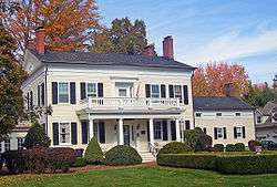 Bykenhulle House Historic Site | |
 Seal | |
 Location of East Fishkill, New York | |
| Coordinates: 41°34′N 73°48′W | |
| Country | United States |
| State | New York |
| County | Dutchess |
| Established | 1849 |
| Government | |
| • Type | Town Council |
| • Town Supervisor | Nicholas D'Alessandro (R) |
| • Town Council | Anil R. Beephan Jr. (R,C,I)
|
| Area | |
| • Total | 57.39 sq mi (148.63 km2) |
| • Land | 56.50 sq mi (146.35 km2) |
| • Water | 0.88 sq mi (2.29 km2) |
| Elevation | 289 ft (88 m) |
| Population (2010) | |
| • Total | 29,029 |
| • Estimate (2016)[2] | 29,439 |
| • Density | 521.01/sq mi (201.16/km2) |
| Time zone | UTC-5 (Eastern (EST)) |
| • Summer (DST) | UTC-4 (EDT) |
| ZIP Codes | 12533, 12590, 12582 (There is no ZIP for East Fishkill. USPS addressing is split between Hopewell Junction, Stormville and Wappingers Falls) |
| Area code(s) | 845 |
| FIPS code | 36-027-21996 |
| GNIS feature ID | 0978917 |
| Website | eastfishkillny |
Hudson Valley Research Park (formerly known as IBM East Fishkill) is located in the town, and housed 27 divisions and 4,700 regular employees for IBM Microelectronics, which GlobalFoundries bought. While IBM produced microchips they owned the advanced, automated processor fabrication facility where IBM's "Cell" processor was co-developed.
History
One early settler arrived around 1759. The town of East Fishkill was established in 1849 from the eastern part of the town of Fishkill. Its name comes from Fishkill Creek, known as the Vis Kill (Fish Creek) to the Dutch settlers in the area.[4]
Geography
According to the United States Census Bureau, the town has a total area of 57.4 square miles (148.6 km2), of which 56.5 square miles (146.3 km2) is land and 0.89 square miles (2.3 km2), or 1.54%, is water.[3]
East Fishkill is bordered on the west by Fishkill and Wappinger, on the north by LaGrange, and on the east by Beekman and Pawling. The south town line borders Philipstown and Kent, both of which are part of Putnam County.
Interstate 84 and the Appalachian Trail pass across the town. The Taconic State Parkway runs north-south as well.
Demographics
| Historical population | |||
|---|---|---|---|
| Census | Pop. | %± | |
| 1850 | 2,610 | — | |
| 1860 | 2,544 | −2.5% | |
| 1870 | 2,305 | −9.4% | |
| 1880 | 2,574 | 11.7% | |
| 1890 | 2,175 | −15.5% | |
| 1900 | 1,970 | −9.4% | |
| 1910 | 2,226 | 13.0% | |
| 1920 | 1,944 | −12.7% | |
| 1930 | 1,845 | −5.1% | |
| 1940 | 2,024 | 9.7% | |
| 1950 | 2,565 | 26.7% | |
| 1960 | 4,778 | 86.3% | |
| 1970 | 11,092 | 132.1% | |
| 1980 | 18,091 | 63.1% | |
| 1990 | 22,101 | 22.2% | |
| 2000 | 25,589 | 15.8% | |
| 2010 | 29,029 | 13.4% | |
| Est. 2016 | 29,439 | [2] | 1.4% |
| U.S. Decennial Census[5] | |||
As of the census of 2000, there were 25,589 people, 8,233 households, and 7,006 families residing in the town. The population density was 449.7 people per square mile (173.6/km²). There were 8,495 housing units at an average density of 149.3 per square mile (57.6/km²). The racial makeup of the town was 92.54% white, 2.29% African American, 0.15% Native American, 2.80% Asian, 0.02% Pacific Islander, 0.86% from other races, and 1.34% from two or more races. Hispanic or Latino of any race were 4.04% of the population.
There were 8,233 households out of which 45.8% had children under the age of 18 living with them, 75.7% were married couples living together, 6.5% had a female householder with no husband present, and 14.9% were non-families. Of all households 11.9% were made up of individuals and 3.9% had someone living alone who was 65 years of age or older. The average household size was 3.10 and the average family size was 3.38.
In the town, the population was spread out with 29.7% under the age of 18, 6.4% from 18 to 24, 30.4% from 25 to 44, 25.5% from 45 to 64, and 8.0% who were 65 years of age or older. The median age was 37 years. For every 100 females, there were 98.9 males. For every 100 females age 18 and over, there were 96.9 males.
The mean income for a household in the town was $116,059, and the mean income for a family was $129,660.[6] Males had a median income of $59,735 versus $35,014 for females. The per capita income for the town was $28,553. About 1.5% of families and 2.8% of the population were below the poverty line, including 2.7% of those under age 18 and 3.7% of those age 65 or over.
Locations
- East Fishkill – A hamlet.
- Fishkill Plains – A hamlet in the northwest part of the town.
- Gayhead – A location south of East Fishkill hamlet.
- Green Haven Correctional Facility – A maximum security prison that is located in the town of Beekman
- Hillside Lake – A location northeast of Fishkill Plains.
- Hopewell Junction – A hamlet in the northwest part of the town.
- Hortontown – A hamlet in the eastern part.
- Leetown - An area on top of Stormville Mountain, named after early settlers.
- The Ville - The Ville is a name derived from Stormville, the hamlet where The Ville is located in. It is known for its secluded forests, and Kiyiwana Farm.
- Johnsville – A hamlet near the west border.
- Lomala – A hamlet south of Hopewell Junction.
- Pecksville – A hamlet in the southeast corner of the town.
- Shenandoah Corners – A hamlet in the south part of the town.
- Stormville – A hamlet in the eastern part of the town named after early settlers, brothers Jacob and Rupert Storm.
- Wiccopee – A hamlet near the west town line.
See also

References
- "2016 U.S. Gazetteer Files". United States Census Bureau. Retrieved Jul 4, 2017.
- "Population and Housing Unit Estimates". Census.gov. Retrieved June 9, 2017.
- "Geographic Identifiers: 2010 Demographic Profile Data (G001): East Fishkill town, Dutchess County, New York". U.S. Census Bureau, American Factfinder. Archived from the original on February 13, 2020. Retrieved November 12, 2015.
- Hooper Shelton. "Fisher County". Texas State Historical Association. Retrieved 2012-05-24.
- "Census of Population and Housing". Census.gov. Retrieved June 4, 2015.
- "Archived copy". Archived from the original on April 5, 2019. Retrieved March 17, 2013.CS1 maint: archived copy as title (link)
External links
| Wikimedia Commons has media related to East Fishkill, New York. |
- Town of East Fishkill official website
- East Fishkill Historical Society
- "Historic Hopewell Junction" video (includes East Fishkill)
- Fishkill Creek Watershed Association
- East Fishkill Fire District
- East Fishkill Community Library
Municipalities and communities of Dutchess County, New York, United States | ||
|---|---|---|
| Cities | 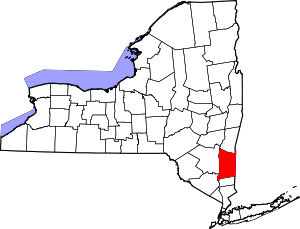 | |
| Towns | ||
| Villages | ||
| CDPs |
| |
| Other hamlets | ||
| Former communities | ||
| Footnotes | ‡This populated place also has portions in an adjacent county or counties | |
| Authority control |
|
|---|