U.S. Route 160 in Colorado
U.S. Route 160 (US 160) is a part of the U.S. Highway System that travels from Tuba City, Arizona, to Poplar Bluff, Missouri. In the State of Colorado, US 160 starts at the New Mexico state line southwest of Cortez and ends at the Kansas state line east of Springfield.
| ||||
|---|---|---|---|---|
_map.svg.png) Map of Colorado with US 160 highlighted in red | ||||
| Route information | ||||
| Maintained by CDOT | ||||
| Length | 490.0 mi (788.6 km) | |||
| Existed | 1926–present | |||
| Major junctions | ||||
| West end | ||||
| ||||
| East end | ||||
| Location | ||||
| Counties | Montezuma, La Plata, Archuleta, Mineral, Rio Grande, Alamosa, Costilla, Huerfano, Las Animas, Baca | |||
| Highway system | ||||
|
Colorado State Highways
| ||||

Route description
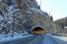
US 160 enters Colorado near the Four Corners Monument. It goes northeast and intersects US 491, then turns north to enter Cortez with US 491. East of Cortez, a road leads south from US 160 to Mesa Verde National Park. It continues east to Durango, where it intersects US 550. After overlapping with US 550 south of Durango, US 160 turns east and meets US 84 at Pagosa Springs. It then goes northeast and crosses the Continental Divide at Wolf Creek Pass, the area made popular in 1975 in C.W. McCall's album Wolf Creek Pass.
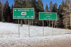
From Wolf Creek Pass, US 160 continues northeast and turns east at South Fork. At Monte Vista, an overlap begins with US 285, which continues southeast into Alamosa. It turns east, then goes northeast to go through North La Veta Pass, then continues east to Walsenburg, where it intersects Interstate 25 (I-25).
From Walsenberg, US 160 continues south with I-25 to Trinidad, then turns northeast to intersect US 350. It continues east, passing through the Comanche National Grassland before intersecting the concurrent US 287 and US 385 south of Springfield. It continues east and enters Kansas east of Walsh.
History
| |
|---|---|
| Location | Flagstaff, AZ–Cortez, CO |
| Existed | 1964–1970 |
As commissioned in 1930 the western terminus was Trinidad.[1] In 1939, US 160 absorbed all of former route U.S. Highway 450 which ran from US 50 at Crescent Junction, Utah to US 85 at Walsenburg.[2]
In 1970, many US Highways in the Four Corners region were realigned. US 160 was diverted southwesterly from Cortez to follow its present route past the Four Corners into Arizona, absorbing the route numbered U.S. Highway 164.[3]
Junction list
| County | Location | mi | km | Destinations | Notes | |||
|---|---|---|---|---|---|---|---|---|
| Montezuma | | 0.00 | 0.00 | Continuation into New Mexico | ||||
| | 4.9 | 7.9 | Southern Terminus of SH-41 | |||||
| | 18.2 | 29.3 | Western end of US 491 concurrency | |||||
| Cortez | 37.9 | 61.0 | Eastern end of US 491 concurrency | |||||
| 40.3 | 64.9 | Southern Terminus of SH-145 | ||||||
| Mancos | 45 | 72 | Mesa Top Ruins Rd | Interchange | ||||
| 54.6 | 87.9 | |||||||
| 56.0 | 90.1 | |||||||
| 57.0 | 91.7 | |||||||
| La Plata | Hesperus | 72.7 | 117.0 | |||||
| Durango | 83.2 | 133.9 | Western end of US 550 concurrency | |||||
| 85.9 | 138.2 | |||||||
| | 87.6 | 141.0 | Eastern end of US 550 concurrency | |||||
| | 90.6 | 145.8 | Interchange; access to Mercy Regional Medical Center | |||||
| | 90.6 | 145.8 | Access to Durango-La Plata County Airport | |||||
| Bayfield | 100.6 | 161.9 | ||||||
| 102.7 | 165.3 | |||||||
| Archuleta | | 126.1 | 202.9 | |||||
| Pagosa Springs | 143.5 | 230.9 | Northern terminus of US 84 | |||||
| Mineral |
No major junctions | |||||||
| Rio Grande | South Fork | 184.9 | 297.6 | |||||
| Del Norte | 200.9 | 323.3 | ||||||
| Monte Vista | 214.5 | 345.2 | Western end of US 285 concurrency | |||||
| Alamosa | Alamosa | 231.6 | 372.7 | Eastern end of US 285 concurrency; western end of SH 17 concurrency | ||||
| Rio Grande | 232.6 | 374.3 | Bridge | |||||
| Alamosa East | 232.8 | 374.7 | Eastern end of SH 17 concurrency | |||||
| Costilla | | 246.7 | 397.0 | |||||
| Fort Garland | 257.1 | 413.8 | ||||||
| Huerfano | | 292.9 | 471.4 | |||||
| Walsenburg | 304.1 | 489.4 | Western end of I-25 Bus. concurrency | |||||
| 304.3 | 489.7 | Main Street north (I-25 Bus. north) | Eastern end of I-25 Bus. concurrency | |||||
| 305.2 | 491.2 | Western end of I-25/US 85/US 87 concurrency; I-25 exit 50; western terminus of SH 10 | ||||||
| See I-25 | ||||||||
| Las Animas | Trinidad | 340.4 | 547.8 | Eastern end of I-25/US 85/US 87 concurrency; I-25 exit 15 | ||||
| No access eastbound | ||||||||
| 341.2 | 549.1 | Serves Mt. San Rafael Hospital; former US 160 west | ||||||
| | 346.6 | 557.8 | Access to Perry Stokes Airport | |||||
| | 375.8 | 604.8 | ||||||
| | 409.5 | 659.0 | ||||||
| Baca | Springfield | 457.1 | 735.6 | |||||
| | 465.0 | 748.3 | ||||||
| | 490.0 | 788.6 | Continuation into Kansas | |||||
1.000 mi = 1.609 km; 1.000 km = 0.621 mi
| ||||||||
References
- U.S. Highway Ends by Dale Sanderson (Mapguy), Last Retrieved September 25, 2007
- U.S. Highway Ends by Dale Sanderson (Mapguy), Last Retrieved September 25, 2007
- U.S. Highway Ends by Dale Sanderson (Mapguy), Last Retrieved September 25, 2007
| Previous state: New Mexico |
Colorado | Next state: Kansas |