Colorado State Highway 12
State Highway 12 (SH 12), also known as the Highway of Legends, in the U.S. state of Colorado is a mountainous state highway through the Rocky Mountains in southern Colorado. The route travels from La Veta through the mountains to Trinidad. It is included in the Colorado Scenic and Historic Byways system and runs through the San Isabel National Forest.
| ||||
|---|---|---|---|---|
| Highway of Legends | ||||
 Map of southern Colorado with SH 12 highlighted in red | ||||
| Route information | ||||
| Maintained by CDOT | ||||
| Length | 70.39 mi[1] (113.28 km) | |||
| Major junctions | ||||
| CW end | ||||
| CCW end | ||||
| Location | ||||
| Counties | Huerfano, Las Animas | |||
| Highway system | ||||
Colorado State Highways
| ||||

Route description
SH 12 begins at the junction with U.S. Route 160 (US 160) north of La Veta. It heads southward through that town before entering the San Isabel National Forest and passing through Cuchara, near the Spanish Peaks Wilderness. It then crosses Cucharas Pass into Las Animas County.
SH 12 heads through Monument Park and turns eastward near Stonewall Gap. It then passes eastward along the Purgatoire River through Weston, Segundo, Valdez, Cokedale, and Jansen. It then ends in Trinidad at an intersection with Interstate 25, US 85, and US 87.
History
The route was established in the 1920s, beginning at Stonewall at SH 111 east to Trinidad and La Junta. The Trinidad-La Junta section was replaced by US 350 in 1957 and the route was paved from Weston to Trinidad in 1939. The entire route was paved by 1946. In 1954, SH 111 was changed, leaving SH 12's terminus without another state highway.[2] In 1970, SH 12 was extended to US 160, and the segment was paved a year later. The route was designated a Colorado Scenic and Historic Byway in 1989.[3]
Major intersections
| County | Location | mi[1] | km | Destinations | Notes |
|---|---|---|---|---|---|
| Huerfano | La Veta | 0.000 | 0.000 | Clockwise terminus; access to Spanish Peaks Regional Health Center | |
| Cucharas Pass | 22.266 | 35.834 | Summit (elevation 9,941 feet (3,030 m)) | ||
| Las Animas | Trinidad | 70.485 | 113.435 | Counterclockwise terminus; I-25 exit 13 | |
| 1.000 mi = 1.609 km; 1.000 km = 0.621 mi | |||||
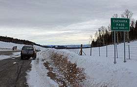 Cuchara Pass on Highway 12.
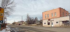 The highway as it passes through Segundo, Colorado.
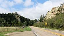
 The highway as it passes through the town of Cuchara, Colorado.
References
- "Segment list for SH 12". Retrieved 2007-05-12.
- Salek, Matthew E. (2010-01-30). "Colorado Routes 1-19". Retrieved 2010-04-04.
- "Scenic Byways at 20" (PDF). Colorado Department of Transportation. Retrieved 4 December 2009.
External links
| Wikimedia Commons has media related to Colorado State Highway 12. |