Tuba City, Arizona
Tuba City (Navajo: Tó Naneesdizí) is an unincorporated town in Coconino County, Arizona, on Navajo lands, in the United States. It is the second-largest community in Coconino County. The population of the census-designated place (CDP) was 8,611 at the 2010 census.[4] It is the Navajo Nation's largest community, slightly larger than Shiprock, New Mexico, and the headquarters of the Western Navajo Agency. The Hopi village of Moenkopi lies directly to its southeast.
Tuba City, Arizona | |
|---|---|
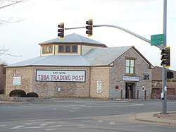 Tuba Trading Post built in 1905 | |
 Location in Coconino County and the state of Arizona | |
| Coordinates: 36°08′06″N 111°14′24″W[1] | |
| Country | United States |
| State | Arizona |
| County | Coconino |
| Area | |
| • Total | 8.97 sq mi (23.24 km2) |
| • Land | 8.97 sq mi (23.24 km2) |
| • Water | 0.00 sq mi (0.00 km2) |
| Elevation | 4,961 ft (1,512 m) |
| Population (2010) | |
| • Total | 8,611 |
| • Estimate (2016)[3] | N/A |
| Time zone | UTC-7 (MST) |
| • Summer (DST) | UTC-6 (MDT) |
| ZIP code | 86045 |
| Area code | 928 |
| FIPS code | 04-76010 |
| GNIS feature ID | 0012802 [1] |
The name of the town honors Tuuvi, a Hopi man from Oraibi who converted to Mormonism. The Navajo name for Tuba City, Tó Naneesdizí translates as "tangled waters", which probably refers to the many below-ground springs that are the source of several reservoirs.
Tuba City is located within the Painted Desert near the western edge of the Navajo Nation. The town is situated on U.S. Route 160, near the junction with Arizona State Route 264. Tuba City is located about 50 miles (80 km) from the eastern entrance to Grand Canyon National Park and approximately 78 miles (126 km) from Flagstaff. Most of Tuba City's residents are Navajo, with a small Hopi minority. It is located within Arizona's 1st Congressional District, currently represented by Tom O'Halleran.[5]
History

The written history of the town dates back more than 200 years. When Father Francisco Garcés visited the area in 1776, he recorded that the Hopi Indians were cultivating crops.[6]
The town was named after Tuuva, a Hopi man. Tuuva converted to Mormonism circa 1870, and invited the Mormons to settle near Moenkopi without permission.
Tuba City was founded by the Mormons in 1872. Tuba City drew Navajo and Paiute Indians to the area because of its natural springs, Hopi Indians were already present. In 1956, Tuba City became a uranium town, as the regional office for the Rare Metals Corporation[7] and the Atomic Energy Commission.[8] The mill closed in 1966, and reclamation of the millsite and tailings pile was completed in 1990.[9]
Geography and climate
According to the United States Census Bureau, the CDP has a total area of 8.9 square miles (23 km2), all land. [10]
Geologically, Tuba City sits upon the Glen Canyon Group from the early Jurassic (about 180-210 Ma) and on modern superficial Quaternary deposits.[11]
Arizona does not currently observe Daylight Saving Time, though the Navajo reservation does. In practice the community has a varied observance: tribal offices and schools observe DST, while most businesses do not.
Tuba City, owing to its location in the rain shadow of the Mogollon Rim which keeps out moisture from the Gulf of California, has a cold desert climate (Köppen BWk) with hot, dry summers—though less hot than Phoenix—and cold, dry winters. Frosts are normal from October to April but the majority of winters do not have measurable snowfall due to the dryness of the air descending from mountains to the south.
| Climate data for Tuba City, Arizona (1971 to 2000) | |||||||||||||
|---|---|---|---|---|---|---|---|---|---|---|---|---|---|
| Month | Jan | Feb | Mar | Apr | May | Jun | Jul | Aug | Sep | Oct | Nov | Dec | Year |
| Record high °F (°C) | 76 (24) |
76 (24) |
84 (29) |
94 (34) |
100 (38) |
110 (43) |
110 (43) |
108 (42) |
103 (39) |
92 (33) |
80 (27) |
71 (22) |
110 (43) |
| Average high °F (°C) | 45.4 (7.4) |
53.0 (11.7) |
60.1 (15.6) |
68.3 (20.2) |
77.7 (25.4) |
88.8 (31.6) |
93.4 (34.1) |
90.7 (32.6) |
83.4 (28.6) |
71.9 (22.2) |
56.3 (13.5) |
46.0 (7.8) |
69.6 (20.9) |
| Daily mean °F (°C) | 33.8 (1.0) |
39.7 (4.3) |
46.2 (7.9) |
53.2 (11.8) |
62.5 (16.9) |
72.2 (22.3) |
78.0 (25.6) |
75.8 (24.3) |
68.2 (20.1) |
56.4 (13.6) |
43.2 (6.2) |
33.8 (1.0) |
55.3 (12.9) |
| Average low °F (°C) | 22.2 (−5.4) |
26.4 (−3.1) |
32.2 (0.1) |
38.0 (3.3) |
47.2 (8.4) |
55.5 (13.1) |
62.5 (16.9) |
60.9 (16.1) |
53.0 (11.7) |
40.8 (4.9) |
30.0 (−1.1) |
21.5 (−5.8) |
40.9 (4.9) |
| Record low °F (°C) | −15 (−26) |
−9 (−23) |
5 (−15) |
13 (−11) |
10 (−12) |
30 (−1) |
34 (1) |
40 (4) |
20 (−7) |
11 (−12) |
−4 (−20) |
−13 (−25) |
−15 (−26) |
| Average precipitation inches (mm) | 0.55 (14) |
0.52 (13) |
0.59 (15) |
0.27 (6.9) |
0.32 (8.1) |
0.17 (4.3) |
0.66 (17) |
0.69 (18) |
0.98 (25) |
0.85 (22) |
0.43 (11) |
0.32 (8.1) |
6.35 (162.4) |
| Average snowfall inches (cm) | 0.8 (2.0) |
0.8 (2.0) |
0.1 (0.25) |
0.0 (0.0) |
0.0 (0.0) |
0.0 (0.0) |
0.0 (0.0) |
0.0 (0.0) |
0.0 (0.0) |
0.0 (0.0) |
0.0 (0.0) |
0.9 (2.3) |
2.6 (6.55) |
| Average precipitation days (≥ 0.01 inch) | 4.2 | 3.6 | 5.3 | 2.3 | 3.2 | 2.3 | 6.3 | 6.8 | 4.7 | 4.1 | 3.1 | 3.6 | 49.5 |
| Average snowy days (≥ 0.1 inch) | 0.6 | 0.4 | 0.1 | 0.0 | 0.0 | 0.0 | 0.0 | 0.0 | 0.0 | 0.0 | 0.0 | 0.0 | 1.1 |
| Source: [12] | |||||||||||||
Demographics
| Historical population | |||
|---|---|---|---|
| Census | Pop. | %± | |
| U.S. Decennial Census[13] | |||
| Languages (2000) [14] | Percent |
|---|---|
| Spoke Navajo at home | 61.20% |
| Spoke English at home | 38.51% |
| Spoke Hopi at home | .46% |
| Spoke Spanish at home | 0.83% |
As of the census[15] of 2015, there were 9,722 people, 2,360 households, and 1,675 families residing in the CDP. The population density was 921.6 people per square mile (356.0/km²). There were 2,465 housing units at an average density of 274.0 per square mile (105.8/km²). The racial make-up of the CDP was 76.17% Native American, 8.36% White, 0.31% Black or African American, 0.8% Asian, 0.04% Pacific Islander, 0.63% from other races, and 1.47% from two or more races. 14.35% of the population were Hispanic or Latino of any race.
There were 2,360 households out of which 52.9% had children under the age of 18 living with them, 49.0% were married couples living together, 26.0% had a female householder with no husband present, and 17.7% were non-families. 15.1% of all households were made up of individuals and 2.3% had someone living alone who was 65 years of age or older. The average household size was 4.00 and the average family size was 4.49.
In the CDP, the age distribution of the population shows 42.8% under the age of 18, 9.8% from 18 to 24, 27.5% from 25 to 44, 15.7% from 45 to 64, and 4.3% who were 65 years of age or older. The median age was 23 years. For every 100 females, there were 93.8 males. For every 100 females age 18 and over, there were 87.3 males.
Tuba City's median household income is $47,091, and the median income for a family was $37,813. Males had a median income of $29,280 versus $26,855 for females. The per capita income for the CDP was $14,140. About 23.1% of families and 28.2% of the population were below the poverty line, including 33.0% of those under age 18 and 44.8% of those age 65 or over.
Attractions


- The Explore Navajo Interactive Museum opened in 2007 in the center of Tuba City, next to the historic Tuba City Trading Post.
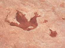
- Tuba City is noted for dinosaur tracks, found about 5 miles (8 km) west.
- Coal Mine Canyon, a colorful canyon with many hoodoos, is 15 miles (24 km) southeast.
- Hahonogeh Canyon, near Coal Mine Canyon, is noteworthy for its blue colors at sunrise and sunset.
The Hopi tribe opened the Tuuvi Travel Center in 2008, a $6.3 million complex. They opened a 13 million dollar motel in 2010 and Denny's restaurant in 2011 across the street on US Highway 160. The Hopi Nation plan a $100 million "Gateway to Hopiland" nearby.[8]
Tuba City is served by the Tuba City Airport.
Education
The area is served by the Tuba City Unified School District, as well as several independent schools within the area.
Schools in Tuba City include:
- Tuba City High School
- Greyhills Academy High School
- Tuba City Boarding School established c1906
- Tuba City Primary School
- Tuba City Jr. High School
- Eagles' Nest Intermediate School
- Nizhoni Accelerated Academy
- Diné College
- Online classes from Northern Arizona University.
- Moencopi Day School
Sports
Tuba City High School was awarded the 1982 National Cross Country Championship through the XC Legacy series published through Milesplit.us in an effort to begin filling in the national rankings from 1980-1988. The Harrier Magazine, operated by Marc Bloom formerly of Runners World Magazine began keeping official rankings in 1989. The National Title is the first for historic Coach Bud Davis and caps off a remarkable season and school Legacy of eight straight state titles, eleven in thirteen seasons. Tuba City High School's varsity volleyball team are 2012 Champions. Also, Tuba City High School's Cross-Country team took 1st in the state in 2013.[16]
On January 4, 1988, Northern Arizona beat Central Connecticut 72-70 in Tuba City in the first Division I basketball game ever played on an Indian reservation.
Notable residents
- Mary Morez, artist, was born near Tuba City[17]
- Lori Piestewa, a soldier in the US Army, was killed in southern Iraq in 2003. In honor of her, Squaw Peak in Phoenix was renamed Piestewa Peak in 2008.
- Aaron Yazzie, a mechanical engineer at NASA's Jet Propulsion Laboratory, was born in Tuba City.
References
- U.S. Geological Survey Geographic Names Information System: Tuba City, Arizona
- "2016 U.S. Gazetteer Files". United States Census Bureau. Retrieved Jul 18, 2017.
- "Population and Housing Unit Estimates". Census.gov. Retrieved June 9, 2017.
- "Profile of General Population and Housing Characteristics: 2010 Demographic Profile Data (DP-1): Tuba City CDP, Arizona". United States Census Bureau. Retrieved December 8, 2011.
- "Congressman Tom O´Halleran". Congressman Tom O´Halleran. Retrieved 12 October 2017.
- "Arizona Relocation Guide". Arizonan.com. Archived from the original on 4 November 2013. Retrieved 12 October 2017.
- "Tuba City Mill". Eia.doe.gov. Retrieved 12 October 2017.
- Amy Maestas, "Tuba City, Arizona" Archived 2008-08-28 at the Wayback Machine, Inside Outside Southwest Archived 2013-01-27 at Archive.today, July 2008,
- "The Center for Land Use Interpretation". Clui.org. Retrieved 12 October 2017.
- "US Gazetteer files: 2010, 2000, and 1990". United States Census Bureau. 2011-02-12. Retrieved 2011-04-23.
- "The Arizona Geological Survey - Geologic Map of Arizona (1:1,000,000 scale)". Web.archive.org. 16 October 2009. Archived from the original on 16 October 2009. Retrieved 12 October 2017.CS1 maint: BOT: original-url status unknown (link)
- "TUBA CITY, AZ" (PDF). National Oceanic and Atmospheric Administration. Retrieved March 27, 2013.
- "Census of Population and Housing". Census.gov. Retrieved June 4, 2016.
- "Data Center Results". apps.mla.org. Retrieved 12 October 2017.
- "U.S. Census website". United States Census Bureau. Retrieved 2008-01-31.
- "Tuba City National Title Top 3 Photo". Ut.milesplit.us. Archived from the original on 21 April 2013. Retrieved 12 October 2017.
- "Mary Morez – Artist, Fine Art Prices, Auction Records for Mary Morez". Askart.com. Retrieved 28 January 2017.
External links
| Wikimedia Commons has media related to Tuba City, Arizona. |

- Arizonan.com profile
- Tuba City Unified School District - local photos
- Greyhills Academy - local photos
- Local news
Municipalities and communities of Coconino County, Arizona, United States | ||
|---|---|---|
| Cities | 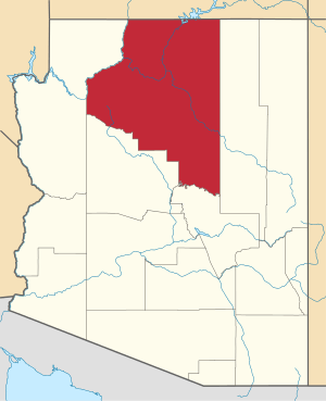 | |
| Towns | ||
| CDPs | ||
| Populated places |
| |
| Indian reservations | ||
| Ghost towns | ||
| Footnotes | ‡This populated place also has portions in an adjacent county or counties | |
| Authority control |
|
|---|