Tvedestrand
![]()
Tvedestrand kommune | |
|---|---|
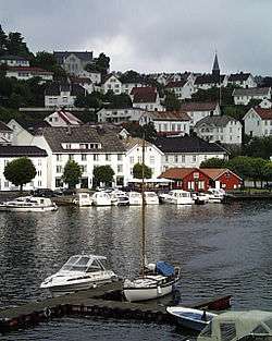 View of Tvedestrand | |
 Coat of arms  Agder within Norway | |
 Tvedestrand within Agder | |
| Coordinates: 58°37′26″N 08°55′40″E | |
| Country | Norway |
| County | Agder |
| District | Østre Agder |
| Administrative centre | Tvedestrand |
| Government | |
| • Mayor (2003) | Jan Dukene (Tvedestrand Tverrpolitiske Liste) |
| Area | |
| • Total | 215.05 km2 (83.03 sq mi) |
| • Land | 203.94 km2 (78.74 sq mi) |
| • Water | 11.11 km2 (4.29 sq mi) |
| Area rank | 324 in Norway |
| Population (2017) | |
| • Total | 6,051 |
| • Rank | 172 in Norway |
| • Density | 29.7/km2 (77/sq mi) |
| • Change (10 years) | 3.9% |
| Time zone | UTC+01:00 (CET) |
| • Summer (DST) | UTC+02:00 (CEST) |
| ISO 3166 code | NO-4213 |
| Official language form | Bokmål[1] |
| Website | www |
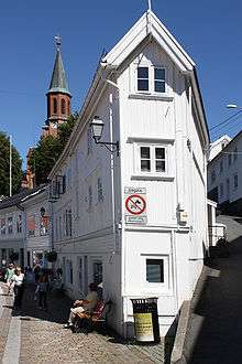
The town of Tvedestrand has a white-painted town center with irregular streets climbing steep hills around the harbor. The natural environment of the area makes it a tourist destination. The municipality includes numerous islands, which makes it popular in the summer for boaters. The number of people in the municipality practically doubles in the summer, due to vacationers. There are approximately 1,700 summer cottages ("hytter") around the fjord and coastal areas. Tvedestrand has over 2,000 buildings that are more than 100 years old.[3]
The 215-square-kilometre (83 sq mi) municipality is the 324th largest by area out of the 422 municipalities in Norway. Tvedestrand is the 172nd most populous municipality in Norway with a population of 6,051. The municipality's population density is 29.7 inhabitants per square kilometre (77/sq mi) and its population has increased by 3.9% over the last decade.[4]
General information
The town of Tvedestrand was established as a municipality on 1 January 1838 (see formannskapsdistrikt). During the 1960s, there were many municipal mergers across Norway due to the work of the Schei Committee. On 1 January 1960, the rural municipalities of Dypvåg (population: 1,805) and Holt (population: 3,759) were merged with the town of Tvedestrand (population: 868) to form a new municipality named Tvedestrand.
On 1 January 1962, the Strengereid area (population: 375) of Tvedestrand was transferred to neighboring Moland municipality. Then on 1 January 1964, the Holtegården area (population: 5) was transferred from Moland to Tvedestrand. The uninhabited Folevatnet area in Tvedestrand was transferred to the municipality of Risør on 1 January 1984.[5]
Name
The town (and municipality) are named after the old Tveite farm (Old Norse: Þveitar) where the town now sits. The first element is the genitive case of the farm name and the last element is strond which means "strand" or "beach". The name of the farm is the plural form of þveit which means "small farm".[2]
Coat-of-arms
The coat-of-arms is from modern times; they were granted on 4 April 1986. The white and blue arms show a white tern, a typical seabird, on a blue background. The tern and blue background were chosen to represent the sea since the municipality was historically dependent on it for its economy.[6]
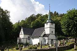
Churches
The Church of Norway has three parishes (sokn) within the municipality of Tvedestrand. It is part of the Aust-Nedenes prosti (deanery) in the Diocese of Agder og Telemark.
| Parish (Sokn) | Church Name | Location of the Church | Year Built |
|---|---|---|---|
| Dypvåg | Dypvåg Church | Dypvåg | c. 1200 |
| Holt | Holt Church | Fiane | c. 1100 |
| Laget Church | Laget | 1908 | |
| Tvedestrand | Tvedestrand Church | Tvedestrand | 1861 |
History
Holt Church probably dates from the twelfth century and it has an ancient baptismal font. The interior was decorated by Torsten Hoff.
Around 1600, Tvedestrand was mainly a harbour for the Berge and Tveite farms’ boats, hence the name Tvedestrand (strand means beach or coast in Norwegian).
Lyngør was the site of the Battle of Lyngør between English and Dano-Norwegian forces during the Napoleonic Wars resulting in the sinking of the frigate of the Dano-Norwegian forces, Najaden by the British ship-of-the-line Dictator in 1812.
The town, as it now exists, was built in the 19th century as a harbour for Norway's longest existing iron works, Næs jernverk. Lying in the parish of Holt, Næs jernverk has one of the largest and most significant of the surviving mansions in Sørlandet, built by Ulrich Schnell. Schnell bought up various iron works in the neighborhood and set up several sawmills in the district. He obtained a special license to export timber directly from Tvedestrand, establishing the basis for an international harbor.[7]
Government
.jpg)
All municipalities in Norway, including Tvedestrand, are responsible for primary education (through 10th grade), outpatient health services, senior citizen services, unemployment and other social services, zoning, economic development, and municipal roads. The municipality is governed by a municipal council of elected representatives, which in turn elect a mayor.
Municipal council
The municipal council (Kommunestyre) of Tvedestrand is made up of 25 representatives that are elected to four year terms. Currently, the party breakdown is as follows:[8]
| Party Name (in Norwegian) | Number of representatives | |
|---|---|---|
| Labour Party (Arbeiderpartiet) | 6 | |
| Progress Party (Fremskrittspartiet) | 1 | |
| Green Party (Miljøpartiet De Grønne) | 1 | |
| Conservative Party (Høyre) | 3 | |
| Christian Democratic Party (Kristelig Folkeparti) | 1 | |
| Centre Party (Senterpartiet) | 4 | |
| Liberal Party (Venstre) | 2 | |
| Local List(s) (Lokale lister) | 7 | |
| Total number of members: | 25 | |
Geography
Tvedestrand municipality lies between the towns of Arendal to the southwest and Risør to the northeast. The municipality also borders the municipalities of Arendal, Risør, Froland, Åmli, and Vegårshei.
Tvedestrand belongs to the geographical region of Sørlandet in the Østre Agder area of Aust-Agder county. The town itself lies at the end of a picturesque fjord, Tvedestrandfjorden, which is the name for the inner part of the Oksefjorden (originally Ufsefjorden, meaning the fjord with steep, rocky sides). The municipality also encompasses the islands Borøy, Sandøy, and Askerøya as well as the unique village of Lyngør which lies on several small islands. Lyngør was acclaimed "Europe's best preserved village" by Europa Nostra in 1991. Lyngør Lighthouse is located by the village. Tvedestrand municipality includes 162 islands, with a collected coastline of 214 kilometres (133 mi).
The river Storelva, one of the Southern Coast's best salmon and sea trout rivers, flows past the Næs jernverk and ultimately out into the Sandnesfjorden.
Geology
A number of rare minerals are found in Tvedestrand:
Attractions
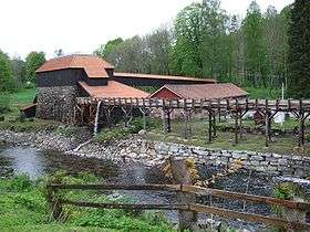
- The 18th century Næs jernverk are 7 kilometres (4.3 mi) from the town center.
- Tvedestrand is recognized as a book town, a small village with a large number of second-hand or antiquarian book shops.
- Interesting Places in Tvedestrand municipality:
Notable residents
- Ketil Bjørnstad (born 1952), a writer who lived there in the 1970s and 80s. The events of his psychological thriller Twilight occur in Tvedestrand
- Arne Garborg (1851–1924), an author. In 1872, he founded and was editor of the Tvedestrandsposten newspaper (still published in 2019)
- Jenny Hval (born 1980), a singer-songwriter
- Knud Knudsen (1812–1895), a linguistics scholar
International relations
Twin towns — Sister cities
The following cities are twinned with Tvedestrand:[9]
References
- "Forskrift om målvedtak i kommunar og fylkeskommunar" (in Norwegian). Lovdata.no.
- Thorsnæs, Geir, ed. (2017-09-28). "Tvedestrand". Store norske leksikon (in Norwegian). Kunnskapsforlaget. Retrieved 2018-01-01.
- Stagg, Frank Noel (1958). South Norway. George Allen & Unwin, Ltd.
- Statistisk sentralbyrå (2017). "Table: 06913: Population 1 January and population changes during the calendar year (M)" (in Norwegian). Retrieved 2018-01-05.
- Jukvam, Dag (1999). "Historisk oversikt over endringer i kommune- og fylkesinndelingen" (PDF) (in Norwegian). Statistisk sentralbyrå.
- "Civic heraldry of Norway - Norske Kommunevåpen". Heraldry of the World. Retrieved 2018-01-04.
- Welle-Strand, Erling (1996). Adventure Roads in Norway. Nortrabooks. ISBN 82-90103-71-9.
- "Table: 04813: Members of the local councils, by party/electoral list at the Municipal Council election (M)" (in Norwegian). Statistics Norway. 2015.
- "Vennskapskommuner" (in Norwegian). Tvedestrand kommune. Archived from the original on 24 July 2007. Retrieved 4 March 2009.
External links
| Wikimedia Commons has media related to Tvedestrand. |
| Look up Tvedestrand in Wiktionary, the free dictionary. |
| Wikivoyage has a travel guide for Aust-Agder. |
- Municipal fact sheet from Statistics Norway (in Norwegian)
- Tvedestrand municipality site (in Norwegian)
- A UK site on Tvedestrand municipality
- Information on minerals in Tvedestrand
- A map of Tvedestrand municipality
- The museum at Næs Jernverks
- Map of Aust-Agder including Tvedestrand municipality (in German)
- The island of Borøya (in Norwegian)
- Culture (in Norwegian)
- The newspaper Garborg founded (in Norwegian)
 |  | ||||||||||||||||||||
|