Åseral
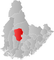
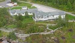
Åseral is a municipality in Agder county, Norway. It is in the traditional district of Sørlandet. The administrative centre of the municipality is the village of Kyrkjebygda. Other villages in Åseral include Eikerapen, Kylland, Ljosland, and Åknes.
Åseral kommune | |
|---|---|
 Coat of arms 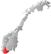 Agder within Norway | |
 Åseral within Agder | |
| Coordinates: 58°42′07″N 07°23′37″E | |
| Country | Norway |
| County | Agder |
| District | Sørlandet |
| Administrative centre | Kyrkjebygda |
| Government | |
| • Mayor (2007) | Oddmund Ljosland (Sp) |
| Area | |
| • Total | 887.52 km2 (342.67 sq mi) |
| • Land | 797.72 km2 (308.00 sq mi) |
| • Water | 89.80 km2 (34.67 sq mi) |
| Area rank | 127 in Norway |
| Population (2017) | |
| • Total | 937 |
| • Rank | 402 in Norway |
| • Density | 1.2/km2 (3/sq mi) |
| • Change (10 years) | 4.9% |
| Demonym(s) | Åsdøl[1] |
| Time zone | UTC+01:00 (CET) |
| • Summer (DST) | UTC+02:00 (CEST) |
| ISO 3166 code | NO-4224 |
| Official language form | Nynorsk[2] |
| Website | www |
Åseral is an inland municipality, bordering the county of Aust-Agder to the east and north. In the south, it borders the municipality of Audnedal, in the southeast with Hægebostad, and in the west with Kvinesdal. Åseral is the headwaters of the river Mandalselva and the Mandalen valley.
The 888-square-kilometre (343 sq mi) municipality is the 127th largest by area out of the 422 municipalities in Norway. Åseral is the 402nd most populous municipality in Norway with a population of 937. The municipality's population density is 1.2 inhabitants per square kilometre (3.1/sq mi) and its population has increased by 4.9% over the last decade.[3]
General information
For centuries, the large parish of Bjelland encompassed the northern half of the Mandalen valley. The northern annex of the parish was Aaserald which was in the neighboring county of Nedenes while the main part of the parish was in Lister og Mandal county. When the formannskapsdistrikt law went into effect on 1 January 1838, each parish was created as a municipality, however, since Bjelland covered areas in two counties, it had to be split into two municipalities. The northern annex became the municipality of Aaserald (later spelled Åseral) in Nedenes county and the rest became the municipality of Bjelland og Grindum in Lister og Mandal county. On 1 September 1880, the municipality of Åseral was transferred from Nedenes county to Lister og Mandal county. Its municipal boundaries have never changed.[4]
Name
The Old Norse form of the name was Ásaráll. The first part of the word is probably the genitive case of áss (m.), meaning "mountain ridge". The last part, áll (m.) means "long strip", probably referring to the long and narrow lake Øre. Historically, the name was spelled Aaserald or Aaseral. Since the early 20th century it has been spelled Åseral.[5]
Coat-of-arms
The coat-of-arms is from modern times; they were granted on 20 January 1989. It shows a silver or white horseshoe opening downwards on a green background. The horseshoe was chosen to represent the historical importance of horses in the farming culture of Åseral as well as the symbol of good luck. The green background represents the importance of forestry.[6]
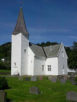
Churches
The Church of Norway has one parish (sokn) within the municipality of Åseral. It is part of the Mandal deanery in the Diocese of Agder og Telemark.
| Parish (Sokn) | Church Name | Location of the Church | Year Built |
|---|---|---|---|
| Åseral | Åseral Church | Kyrkjebygda | 1822 |
| Ljosland Chapel | Ljosland | 1959 | |
| Åknes Chapel | Åknes | 1873 |
Government

All municipalities in Norway, including Åseral, are responsible for primary education (through 10th grade), outpatient health services, senior citizen services, unemployment and other social services, zoning, economic development, and municipal roads. The municipality is governed by a municipal council of elected representatives, which in turn elect a mayor.
Municipal council
The municipal council (Kommunestyre) of Åseral is made up of 17 representatives that are elected to four year terms. Currently, the party breakdown is as follows:[7]
| Party Name (in Nynorsk) | Number of representatives | |
|---|---|---|
| Labour Party (Arbeidarpartiet) | 3 | |
| Conservative Party (Høgre) | 4 | |
| Christian Democratic Party (Kristeleg Folkeparti) | 4 | |
| Centre Party (Senterpartiet) | 6 | |
| Total number of members: | 17 | |
Geography
Åseral is in the central, inland part of Southern Norway. It is in the Setesdalsheiene mountains and adjacent to the Setesdal valley to the northeast. Åseral has many lakes, some of which are dammed for purposes of hydroelectric power. Some of the lakes include Nåvatnet, Juvatn, Øre and Gyvatn. The river Mandalselva and the Mandalen valley both begin in Åseral.
Climate
| Climate data for Åseral | |||||||||||||
|---|---|---|---|---|---|---|---|---|---|---|---|---|---|
| Month | Jan | Feb | Mar | Apr | May | Jun | Jul | Aug | Sep | Oct | Nov | Dec | Year |
| Daily mean °C (°F) | −4.0 (24.8) |
−4.1 (24.6) |
−0.8 (30.6) |
2.9 (37.2) |
8.5 (47.3) |
13.4 (56.1) |
14.7 (58.5) |
13.8 (56.8) |
9.5 (49.1) |
5.9 (42.6) |
1.0 (33.8) |
−2.2 (28.0) |
4.9 (40.8) |
| Average precipitation mm (inches) | 158 (6.2) |
115 (4.5) |
112 (4.4) |
73 (2.9) |
109 (4.3) |
103 (4.1) |
107 (4.2) |
152 (6.0) |
198 (7.8) |
225 (8.9) |
214 (8.4) |
160 (6.3) |
1,726 (68.0) |
| Average precipitation days (≥ 1 mm) | 15.7 | 10.7 | 12.6 | 9.4 | 11.4 | 10.6 | 11.0 | 12.4 | 14.2 | 15.7 | 16.4 | 15.2 | 155.3 |
| Source: Norwegian Meteorological Institute[8] | |||||||||||||
Attractions
Åseral is a popular winter tourist destination with three ski resorts in the villages of Bortelid, Ljosland, and Eikerapen. Eikerapen is also the site of the annual Eikerapen Roots Festival, an international music festival attracting thousands of people from all over Europe.
References
- "Navn på steder og personer: Innbyggjarnamn" (in Norwegian). Språkrådet.
- "Forskrift om målvedtak i kommunar og fylkeskommunar" (in Norwegian). Lovdata.no.
- Statistisk sentralbyrå (2017). "Table: 06913: Population 1 January and population changes during the calendar year (M)" (in Norwegian). Retrieved 2017-11-04.
- Jukvam, Dag (1999). "Historisk oversikt over endringer i kommune- og fylkesinndelingen" (PDF) (in Norwegian). Statistisk sentralbyrå.
- Rygh, Oluf (1912). Norske gaardnavne: Lister og Mandals amt (in Norwegian) (9 ed.). Kristiania, Norge: W. C. Fabritius & sønners bogtrikkeri. p. 134.
- "Kommunevåpen". Åseral kommune. Retrieved 2016-11-12.
- "Table: 04813: Members of the local councils, by party/electoral list at the Municipal Council election (M)" (in Norwegian). Statistics Norway. 2015.
- "eKlima Web Portal". Norwegian Meteorological Institute. Archived from the original on 2004-06-14.
External links


- Municipal fact sheet from Statistics Norway (in Norwegian)
 |  | ||||||||||||||||||||
|