Lillesand
Lillesand (Urban East Norwegian: [ˈlɪ̂lːəsɑn] (![]()
Lillesand kommune | |
|---|---|
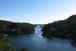 Blindleia in Lillesand | |
 Coat of arms 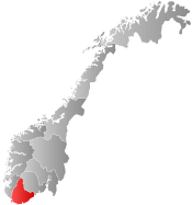 Agder within Norway | |
 Lillesand within Agder | |
| Coordinates: 58°14′49″N 08°19′01″E | |
| Country | Norway |
| County | Agder |
| District | Sørlandet |
| Administrative centre | Lillesand |
| Government | |
| • Mayor (2019) | Einar Holmer-Hoven (H) |
| Area | |
| • Total | 190.43 km2 (73.53 sq mi) |
| • Land | 180.38 km2 (69.65 sq mi) |
| • Water | 10.05 km2 (3.88 sq mi) |
| Area rank | 335 in Norway |
| Population (2017) | |
| • Total | 10,702 |
| • Rank | 109 in Norway |
| • Density | 59.3/km2 (154/sq mi) |
| • Change (10 years) | 17.5% |
| Demonym(s) | Lillesandar Lillesander[1] |
| Time zone | UTC+01:00 (CET) |
| • Summer (DST) | UTC+02:00 (CEST) |
| ISO 3166 code | NO-4215 |
| Official language form | Bokmål[2] |
| Website | www |
The 190-square-kilometre (73 sq mi) municipality is the 335th largest by area out of the 422 municipalities in Norway. Lillesand is the 109th most populous municipality in Norway with a population of 10,702. The municipality's population density is 59.3 inhabitants per square kilometre (154/sq mi) and its population has increased by 17.5% over the last decade.[4]
General information

The town of Lillesand was established as a municipality on 1 January 1838 (see formannskapsdistrikt). During the 1960s, there were many municipal mergers across Norway due to the work of the Schei Committee. On 1 January 1962, the following areas were merged into a new, larger municipality of Lillesand:[5]
- the town of Lillesand (population: 1,041)
- the rural municipality of Høvåg (population: 1,330)
- the rural municipality of Vestre Moland (population: 2,454)
- the Gitmarkgårdene area of Eide municipality (population: 22)
Name
The Old Norse form of the name was just Sandr which means "sand beach". The first element lille which means "little" was added after the founding of Kristiansand in 1641 to distinguish it from the greater and more important town nearby.[6]
Coat-of-arms
The coat-of-arms is from modern times; they were granted on 11 September 1987. The arms show three silver anchors on a blue background. The anchor was chosen to symbolize the connection that the municipality has with the sea and there are three of them to symbolize the three smaller municipalities that were merged in 1964 to form the present municipality.[7][8]
History
Sanden, which consisted of the small area near the harbor, was the original name for the municipality of Lillesand. Lillesand is built on the ancient estate of Lofthus. Christian Jensen Lofthuus was captured on his Lofthus estate around 1780.
In 1821, when Lillesand became a privileged port, it had a population of only 300 and had nine shipyards. By 1895 the merchant fleet was 95 vessels strong. But the death of the sailing ship caused severe economic difficulties for Lillesand. Sailing ships had been inexpensive and could be built from local timber. Steamers were built of steel, were expensive and required more capital than locals could muster. Shipyards were closed. Many of the residents emigrated from there to the United States. Lillesand remained a fishing village, though even this area suffered when the herring left the coast.
The Saltholmen Lighthouse, located on an island off Lillesand, is a nineteenth century lighthouse with a slate roof and a concrete tower for the light. It operated as a manned lighthouse from 1882 to 1952. Saltholmen (lit. "Salty Islet") is named after the salt extraction industry once there, established by Hans Nielsen Hauge.
The Lillesand-Flaksvandbanen operated between Lillesand and Flaksvann from 1896 to 1953.
The Orzeł, a Polish submarine sank the German troop transport Rio de Janeiro on 8 April 1940 off Lillesand. The Rio de Janeiro was on its way to take part in the initial landings of Operation Weserübung the next day, the invasion of Norway.
Geography
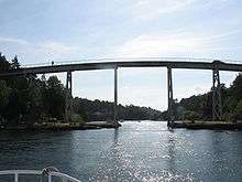
Lillesand is bordered in the north by Birkenes municipality, to the east by Grimstad municipality and to the south by Kristiansand municipality. The lake Østre Grimevann is a large lake in the northern part of the municipality and the river Tovdalselva runs through the municipality too. The Blindleia is an inland waterway that starts in Gamle Hellesund in Høvåg near Kristiansand in southern Norway, and continues past Lillesand. It is a salt water passage protected from the open sea by the offshore archipelago. The island of Justøy lies just south of the town of Lillesand, along the Blindleia. The Kvåsefjorden lies along the southwestern border of Lillesand municipality.
Navigation through the Blindleia passage requires attention to detail, but is not difficult as there are no tides, and very little current. The minimal tidal change in the skerries is due to its geographical location; the tidal flow that comes in from the Atlantic Ocean splits on the British Isles. One tidal stream goes through the English Channel, while the other goes around the north of the British Isles. The stream of the English Channel reaches the coast of Norway before the wave traveling around the British Islands. These two tidal "waves" are completely out of phase when they meet here, neutralizing the tidal effect.
Government
All municipalities in Norway, including Lillesand, are responsible for primary education (through 10th grade), outpatient health services, senior citizen services, unemployment and other social services, zoning, economic development, and municipal roads. The municipality is governed by a municipal council of elected representatives, which in turn elect a mayor.
Municipal council
The municipal council (Kommunestyre) of Lillesand is made up of 27 representatives that are elected to four year terms. Currently, the party breakdown is as follows:[9]
| Party Name (in Norwegian) | Number of representatives | |
|---|---|---|
| Labour Party (Arbeiderpartiet) | 6 | |
| Progress Party (Fremskrittspartiet) | 2 | |
| Green Party (Miljøpartiet De Grønne) | 1 | |
| Conservative Party (Høyre) | 10 | |
| Christian Democratic Party (Kristelig Folkeparti) | 2 | |
| Pensioners' Party (Pensjonistpartiet) | 2 | |
| Centre Party (Senterpartiet) | 1 | |
| Socialist Left Party (Sosialistisk Venstreparti) | 1 | |
| Liberal Party (Venstre) | 2 | |
| Total number of members: | 27 | |
Attractions

The Norwegian National Park Skjærgårdsparken lies between Risør and Lillesand. Skjærgårdsparken, "the Park of Archipelago" is a paradise of islands, skerries, and rocks. Blindleia is a 12 kilometers Inland waterway between Lillesand and Ulvøysund with lots of small boat traffic in the summertime. The village of Brekkestø is tourist area on the island of Justøya.
Lillesand Town- and Maritime Museum is a local, culture historic museum, located in the centre of the town. The museum is also called Carl Knudsen-gården.
The Norwegian author Jostein Gaarder refers to this town in several of his books, for example in Sophie's World, where The Solitaire Mystery refers to Lillesand.
Churches
Lillesand Church is a wooden church which was built in 1887-1889 in Gothic Revival/Swiss style. The architect was Henrik Thrap-Meyer who also designed the pulpit, altarpiece and baptismal font. The altarpiece was done by Abraham Tønnessen. Lillesand Church is perched high above the city on a hill at Kirkeheia.[10] [11]
In the current Lillesand municipality are also the medieval stone churches Vestre Moland Church and Høvåg Church, both of which are listed cultural heritage sites.
International relations
Twin towns — Sister cities
Lillesand has sister city agreements with the following places:[12]
Notable residents
- Christian Jensen Lofthuus, a farm leader and owner of the Lofthus farm
- Knut Hamsun, he bought Nørholm, an old and somewhat dilapidated manor house between Lillesand and Grimstad in 1918 and he lived and wrote at Nørholm until he died there in 1952
- Gabriel Scott (8 March 1874—9 July 1958) was a Norwegian poet, novelist, playwright and children's writer
- N. O. Nelson (1844–1922), the founder of the N. O. Nelson Manufacturing Company
- Heroes & Zeros, a rock band from Lillesand

References
- "Navn på steder og personer: Innbyggjarnamn" (in Norwegian). Språkrådet.
- "Forskrift om målvedtak i kommunar og fylkeskommunar" (in Norwegian). Lovdata.no.
- Berulfsen, Bjarne (1969). Norsk Uttaleordbok (in Norwegian). Oslo: H. Aschehoug & Co (W Nygaard). p. 199.
- Statistisk sentralbyrå (2017). "Table: 06913: Population 1 January and population changes during the calendar year (M)" (in Norwegian). Retrieved 2017-11-05.
- Jukvam, Dag (1999). "Historisk oversikt over endringer i kommune- og fylkesinndelingen" (PDF) (in Norwegian). Statistisk sentralbyrå.
- Thorsnæs, Geir, ed. (2017-10-31). "Lillesand". Store norske leksikon (in Norwegian). Kunnskapsforlaget. Retrieved 2017-11-05.
- "Civic heraldry of Norway - Norske Kommunevåpen". Heraldry of the World. Retrieved 2017-11-05.
- "Om Lillesand" (in Norwegian). Retrieved 2008-10-04.
- "Table: 04813: Members of the local councils, by party/electoral list at the Municipal Council election (M)" (in Norwegian). Statistics Norway. 2015.
- "Lillesand kirke". Den Norske Kirke. Retrieved August 15, 2016.
- "Henrik Thrap-Meyer". Store norske leksikon. Retrieved August 15, 2016.
- "Vennskapskommuner" (in Norwegian). Lillesand kommune. Retrieved 2017-11-05.
External links
| Wikimedia Commons has media related to Lillesand Municipality. |
| Look up Lillesand in Wiktionary, the free dictionary. |
- Municipal fact sheet from Statistics Norway (in Norwegian)

- Municipal website (in Norwegian)
- Lillesand on www.visitnorway.com (in English)
- Welcome to Lillesand Municipality Lillesand Municipality (in English)
- The Sailors of Lillesand (in Norwegian)
- Lillesands-Posten, local newspaper, homepage
 |  | ||||||||||||||||||||
|