Birkenes
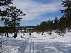
Birkenes is a municipality in Agder county, Norway. It is located in the traditional district of Sørlandet. The administrative centre of the municipality is the village of Birkeland, where about half the municipal population lives. Other villages in Birkenes include Ås, Engesland, Flakk, Håbbesland, Herefoss, Mollestad, Oggevatn, Rugsland, Senumstad, Søre Herefoss, Svaland, Tveide, and Væting.
Birkenes kommune | |
|---|---|
 | |
 Coat of arms 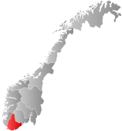 Agder within Norway | |
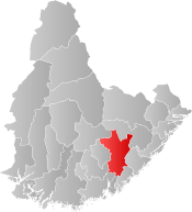 Birkenes within Agder | |
| Coordinates: 58°26′58″N 08°14′00″E | |
| Country | Norway |
| County | Agder |
| District | Sørlandet |
| Administrative centre | Birkeland |
| Government | |
| • Mayor (2015) | Anders Christiansen (Ap) |
| Area | |
| • Total | 674.21 km2 (260.31 sq mi) |
| • Land | 629.91 km2 (243.21 sq mi) |
| • Water | 44.30 km2 (17.10 sq mi) |
| Area rank | 166 in Norway |
| Population (2017) | |
| • Total | 5,178 |
| • Rank | 195 in Norway |
| • Density | 8.2/km2 (21/sq mi) |
| • Change (10 years) | 17.4% |
| Demonym(s) | Birkenesing Borkis[1] |
| Time zone | UTC+01:00 (CET) |
| • Summer (DST) | UTC+02:00 (CEST) |
| ISO 3166 code | NO-4216 |
| Official language form | Neutral[2] |
| Website | www |
The 674-square-kilometre (260 sq mi) municipality is the 166th largest by area out of the 422 municipalities in Norway. Birkenes is the 195th most populous municipality in Norway with a population of 5,178. The municipality's population density is 8.2 inhabitants per square kilometre (21/sq mi) and its population has increased by 17.4% over the last decade.[3]
General information

Name
The municipality (originally the parish) is named after the old Birkenes farm (Old Norse: Birkines), since the first Birkenes Church was built there. The first element is birki which means "birch wood" and the last element is nes which means "headland". This farm is located on the south side of what is now the village of Mollestad.[4]
Coat-of-arms
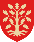
The coat-of-arms is from modern times; they were granted on 5 December 1986. The arms show three birch leaves in white or silver on a green background. The arms are a canting of bjørk which means birch (since bjørk is similar to "birk-" in the name Birkenes). The green color symbolizes the importance of agriculture in the municipality. The three leaves symbolize the three main areas in the municipality: Birkenes in the south, Herefoss in the northeast, and Vegusdal in the northwest.[5]
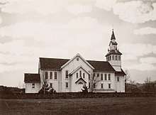
Churches
The Church of Norway has three parishes (sokn) within the municipality of Birkenes. It is part of the Vest-Nedenes prosti (deanery) in the Diocese of Agder og Telemark.
| Parish (Sokn) | Church Name | Location of the Church | Year Built |
|---|---|---|---|
| Birkenes | Birkenes Church | Mollestad | 1858 |
| Herefoss | Herefoss Church | Herefoss | 1865 |
| Vegusdal | Vegusdal Church | Engesland | 1867 |
History
The historic parish of Tveit had to be divided into two formannskapsdistrikts on 1 January 1838 because the main part of Tveit belonged to the county of Lister og Mandal and the annex of Birkenæs belonged to the county of Nedenæs and the new law said a municipality could only exist in one county, not two. Therefore, the parish was split and Birkenæs municipality was created in Nedenæs county. On 1 January 1883, an uninhabited part of Birkenes was transferred to the control of neighboring Landvik municipality.
Starting in the 1960s, Norway enacted many municipal reforms such as mergers and border adjustments stemming from the work of the Schei Committee. On 1 January 1967, the neighboring municipalities of Herefoss (population: 585) and Vegusdal (population: 582) were merged into the municipality of Birkenes, creating a much larger municipality with a population of 3,050.
On 1 January 1970, two uninhabited areas of Neset and Råbudal in the neighboring municipality of Froland were transferred to Birkenes (these areas were formerly in the municipality of Mykland prior to 1967). On 1 January 1979, the uninhabited area of Landheia in Froland was transferred to the control of Birkenes municipality. Later, on 1 January 1986, the Lislevand farm area (population: 8) was transferred from Birkenes to the neighboring municipality of Evje og Hornnes. Then on 1 January 1991, the Dalen area of Birkenes (population: 60) was transferred to the neighboring municipality of Froland.[6] On 1 January 2019, the Hovlandsdalen area (population: 27) was transferred from Birkenes municipality to the neighboring Evje og Hornnes municipality.[7]
Geography
The municipality borders Kristiansand and Vennesla municipalities in Vest-Agder county and Iveland, Evje og Hornnes, Froland, Grimstad, and Lillesand municipalities in Aust-Adger.
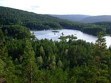
Birkenes is home to many lakes, including Herefossfjorden, Nystølfjorden, Ogge, and Uldalsåna. The river Tovdalselva runs through the municipality as well.
Government
All municipalities in Norway, including Birkenes, are responsible for primary education (through 10th grade), outpatient health services, senior citizen services, unemployment and other social services, zoning, economic development, and municipal roads. The municipality is governed by a municipal council of elected representatives, which in turn elect a mayor.
Municipal council
The municipal council (Kommunestyre) of Birkenes is made up of 21 representatives that are elected to four year terms. Currently, the party breakdown is as follows:[8]
| Party Name (in Norwegian) | Number of representatives | |
|---|---|---|
| Labour Party (Arbeiderpartiet) | 5 | |
| Progress Party (Fremskrittspartiet) | 2 | |
| Conservative Party (Høyre) | 5 | |
| Christian Democratic Party (Kristelig Folkeparti) | 5 | |
| Centre Party (Senterpartiet) | 3 | |
| Liberal Party (Venstre) | 1 | |
| Total number of members: | 21 | |
Economy
Agriculture and logging are important sources of employment, but the municipality also has a small industrial base with about 400 different work sites. The largest enterprise is Owens Corning with approximately 180 employees. Other larger businesses include Uldal Vinduer og Dører, Foss Bad, Scanflex, KOAB Industrier, and Birkeland Trykkeri.
Transportation
The Sørland Line provides rail service at Herefoss Station. Prior to 1953, the Lillesand-Flaksvand Line also served Birkenes, but that railway line was closed down and removed.
Norwegian National Road 41 runs north-south through Birkenes, and is one of the main highways in this area of Norway. There are also several other important county roads in Birkenes, such as Norwegian County Road 404, Norwegian County Road 405, and Norwegian County Road 406.
References
- "Navn på steder og personer: Innbyggjarnamn" (in Norwegian). Språkrådet.
- "Forskrift om målvedtak i kommunar og fylkeskommunar" (in Norwegian). Lovdata.no.
- Statistisk sentralbyrå (2017). "Table: 06913: Population 1 January and population changes during the calendar year (M)" (in Norwegian). Retrieved 2017-11-05.
- Rygh, Oluf (1905). Norske gaardnavne: Nedenes amt (in Norwegian) (8 ed.). Kristiania, Norge: W. C. Fabritius & sønners bogtrikkeri. p. 161.
- "Civic heraldry of Norway - Norske Kommunevåpen". Heraldry of the World. Retrieved 2017-08-20.
- Jukvam, Dag (1999). "Historisk oversikt over endringer i kommune- og fylkesinndelingen" (PDF) (in Norwegian). Statistisk sentralbyrå.
- "Vedtak om endring av kommunegrense – overføring av Hovlandsdalen fra Birkenes kommune til Evje og Hornnes kommune, Aust-Agder fylke" (PDF) (in Norwegian). Fylkesmannen i Aust- og Vest-Agder. 2018-03-21.
- "Table: 04813: Members of the local councils, by party/electoral list at the Municipal Council election (M)" (in Norwegian). Statistics Norway. 2015.
External links
| Wikimedia Commons has media related to Birkenes. |
| Look up Birkenes in Wiktionary, the free dictionary. |
- Municipal fact sheet from Statistics Norway (in Norwegian)

- Welcome to Birkenes - Tourist information
- Kultur i Birkenes på kart from Kulturnett.no (in Norwegian)
 |  | ||||||||||||||||||||
|