Lyngdal
![]()
Lyngdal kommune | |
|---|---|
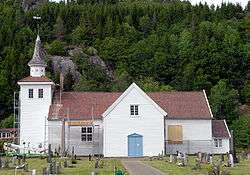
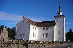 View of the Lyngdal Church | |
 Coat of arms 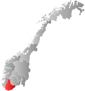 Agder within Norway | |
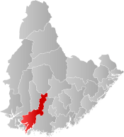 Lyngdal within Agder | |
| Coordinates: 58°10′09″N 07°03′21″E | |
| Country | Norway |
| County | Agder |
| District | Lister |
| Administrative centre | Alleen |
| Government | |
| • Mayor (2013) | Jan Kristensen (H) |
| Area | |
| • Total | 391.17 km2 (151.03 sq mi) |
| • Land | 370.10 km2 (142.90 sq mi) |
| • Water | 21.07 km2 (8.14 sq mi) |
| Area rank | 241 in Norway |
| Population (2017) | |
| • Total | 8,588 |
| • Rank | 129 in Norway |
| • Density | 23.2/km2 (60/sq mi) |
| • Change (10 years) | 16.6% |
| Demonym(s) | Lyngdøl[1] |
| Time zone | UTC+01:00 (CET) |
| • Summer (DST) | UTC+02:00 (CEST) |
| ISO 3166 code | NO-4225 |
| Official language form | Neutral[2] |
| Website | www |
The municipal economy centers around wood processing, agriculture, and commerce. Tourism is also central to the community, with the beaches along the Lyngdalsfjorden and Rosfjorden being popular resorts during the summer.
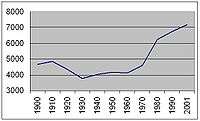
The 391-square-kilometre (151 sq mi) municipality is the 241st largest by area out of the 422 municipalities in Norway. Lyngdal is the 129th most populous municipality in Norway with a population of 8,588. The municipality's population density is 23.2 inhabitants per square kilometre (60/sq mi) and its population has increased by 16.6% over the last decade.[3]
General information
The parish of Aa was established as the municipality of Lyngdal on 1 January 1838 (see formannskapsdistrikt). On 1 January 1909, the municipality was split into three: Austad in the south (population: 1,263), Kvås in the north (population: 736) and Lyngdal in the central area (population: 2,698). During the 1960s, there were many municipal mergers across Norway due to the work of the Schei Committee. On 1 January 1964, the municipalities of Austad (population: 608), Kvås (population: 493), Lyngdal (population: 2,916) as well as the Gitlevåg area (population: 103) in Spangereid municipality, west of Lenesfjorden, were all merged to form one large municipality of Lyngdal. On 1 January 1971, the Ytre Skarstein and Indre Skarstein areas of Lyngdal (population: 21) was transferred to the neighboring municipality of Farsund. On 1 January 2001, the municipality of Lyngdal declared that the municipal centre of Alleen would be a town called Lyngdal.[4]
On 1 January 2020, the neighboring municipalities of Audnedal and Lyngdal will be merged into a new, larger municipality called Lyngdal.[5]
Name
The municipality is named after the Lyngdalen valley in which the municipality is located. The Old Norse form of the name was Lygnudalr. The first element is the genitive case of the river name Lygna and the last element is dalr which means "valley" or "dale". The river name is derived from logn which means "quietness" and so the meaning is "the quiet one". Prior to 1908, the parish (but not the municipality) of Lyngdal was called Aa, named after the vicarage. The name of the vicarage was first mentioned in 1312 as "a Am", the dative plural of á which means '(small) river'. The farm lies between two rivers.[6]
Coat-of-arms
The coat-of-arms is from modern times; they were granted on 27 March 1987. The arms are green with a white cow facing left in the center. The local breed of cows (lyngdalsku) is very well known in Norway and at the yearly cattle fair traders from all over Southern and Western Norway visit the municipality.[7]
- Current arms since 2020
 Arms from 1987 to 2019
Churches
The Church of Norway has three parishes (sokn) within the municipality of Lyngdal. It is part of the Lister prosti (deanery) in the Diocese of Agder og Telemark.
| Parish (Sokn) | Church Name | Location of the Church | Year Built |
|---|---|---|---|
| Austad | Austad Church | Austad | 1803 |
| Korshamn Chapel | Korshamn | 1906 | |
| Kvås | Kvås Church | Kvås | 1836 |
| Lyngdal | Lyngdal Church | Lyngdal | 1848 |
History
The island of Sælør on the southern coast of the municipality is mentioned in Snorre, as the king Saint Olav spent a winter here in 1028. Based around the port of Agnefest, Lyngdal prospered on maritime trade, and in 1771 an application was made for status as a small coastal town. Its coastal location also facilitated emigration; in the 17th and 18th century largely to the Dutch Republic, and in the 19th century to the United States.
Even before the merger of the municipalities in 1964, the parishes of Austad and Kvås, together with Å (or Aa - Lyngdal proper), made up the greater Lyngdal parish. A census from 1801 showed 3529 inhabitants in the area that today makes up Lyngdal: 1850 in Å, 929 in Austad, 585 in Kvås and 165 in the eastern part of Spangereid. The number today is approximately 8000 inhabitants.[8]
Religious life and missionary work have always had a strong position in Lyngdal, and worthy of special note is the minister and Gabriel Kielland (1796–1854), who served in the parish from 1837–1854, and his wife Gustava (1800–1889). Known today as a missionary pioneer and a popular songwriter, Gustava also wrote one of the first autobiographies by a woman in Norway: her "Reminiscence from my Life" from 1880.[9]
Geography
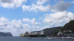
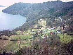
Lyngdal is a coastal municipality that and borders Lindesnes municipality to the southeast, Audnedal to the northeast, Hægebostad to the north, and Kvinesdal and Farsund to the west. Lyngdal municipality includes the southern portion of the Lyngdalen valley which follows the river Lygna to the Lyngdalsfjorden in the west. The Lenesfjorden, Grønsfjorden, and Rosfjorden also are located in the southern part of Lyngdal. As part of Lyngdal village there is Agnefest on site in the south with a natural harbour at Rosfjorden; the harbour is registered since 1771.
Climate
| Climate data for Lyngdal | |||||||||||||
|---|---|---|---|---|---|---|---|---|---|---|---|---|---|
| Month | Jan | Feb | Mar | Apr | May | Jun | Jul | Aug | Sep | Oct | Nov | Dec | Year |
| Daily mean °C (°F) | −0.4 (31.3) |
−0.5 (31.1) |
1.9 (35.4) |
5.0 (41.0) |
10.1 (50.2) |
13.7 (56.7) |
14.7 (58.5) |
14.6 (58.3) |
11.2 (52.2) |
8.0 (46.4) |
3.7 (38.7) |
1.0 (33.8) |
6.9 (44.4) |
| Average precipitation mm (inches) | 167 (6.6) |
112 (4.4) |
118 (4.6) |
79 (3.1) |
104 (4.1) |
95 (3.7) |
109 (4.3) |
148 (5.8) |
198 (7.8) |
219 (8.6) |
223 (8.8) |
173 (6.8) |
1,745 (68.7) |
| Source: Norwegian Meteorological Institute[10] | |||||||||||||
Government
All municipalities in Norway, including Lyngdal, are responsible for primary education (through 10th grade), outpatient health services, senior citizen services, unemployment and other social services, zoning, economic development, and municipal roads. The municipality is governed by a municipal council of elected representatives, which in turn elect a mayor.
Municipal council
The municipal council (Kommunestyre) of Lyngdal is made up of 29 representatives that are elected to four year terms. Currently, the party breakdown is as follows:[11]
| Party Name (in Norwegian) | Number of representatives | |
|---|---|---|
| Labour Party (Arbeiderpartiet) | 3 | |
| Progress Party (Fremskrittspartiet) | 3 | |
| Conservative Party (Høyre) | 12 | |
| Christian Democratic Party (Kristelig Folkeparti) | 6 | |
| Centre Party (Senterpartiet) | 3 | |
| Liberal Party (Venstre) | 2 | |
| Total number of members: | 29 | |
Transportation
Bus lines from/through Lyngdal Bus Terminal:
| Line | Destination |
|---|---|
| 451 | Lyngdal - Flekkefjord/Kvinesdal |
| 781 | Lyngdal - Snartemo S |
| 900 | Kristiansand - Mandal - Farsund |
| 900 | Kristiansand - Mandal - Lista |
| 900 | Lyngdal - Farsund-Lista |
Notable people
- Abraham Berge, politician (1851–1936)[12]
- Teis Lundegaard, politician (1774–1856)[13]
- Trygve Haugeland, politician (1914–1998)[14]
- Kjell Elvis, Elvis Presley impersonator (born 1968)[15]
- Ingvild Stensland, international women's footballer (born 1981)[16]
- Theodore Abrahamson, politician (born 1900)[17]
References
- "Navn på steder og personer: Innbyggjarnamn" (in Norwegian). Språkrådet.
- "Forskrift om målvedtak i kommunar og fylkeskommunar" (in Norwegian). Lovdata.no.
- Statistisk sentralbyrå (2017). "Table: 06913: Population 1 January and population changes during the calendar year (M)" (in Norwegian). Retrieved 2017-11-05.
- Jukvam, Dag (1999). "Historisk oversikt over endringer i kommune- og fylkesinndelingen" (PDF) (in Norwegian). Statistisk sentralbyrå.
- "Nye Lyngdal kommune Informasjonsbrosjyre" (PDF) (in Norwegian). Lyngdal kommune. Retrieved 2017-11-05.
- Rygh, Oluf (1912). Norske gaardnavne: Lister og Mandals amt (in Norwegian) (9 ed.). Kristiania, Norge: W. C. Fabritius & sønners bogtrikkeri. pp. 229–230.
- "Civic heraldry of Norway - Norske Kommunevåpen". Heraldry of the World. Retrieved 2016-10-23.
- "Folkemengde ved folketellingene, 1769-2001" (PDF) (in Norwegian). Statistisk Sentralbyrå. 2001. Retrieved 2008-01-09.
- "History". Lyngdal Municipality. Archived from the original on 2012-04-20. Retrieved 2008-01-09.
- "eKlima Web Portal". Norwegian Meteorological Institute. Archived from the original on 2004-06-14.
- "Table: 04813: Members of the local councils, by party/electoral list at the Municipal Council election (M)" (in Norwegian). Statistics Norway. 2015.
- "Abraham Berge". Norwegian Encyclopedia AS. Retrieved February 24, 2014.
- "Teis Lundegaard". Norwegian Encyclopedia AS. Retrieved February 24, 2014.
- "Haugeland, Trygve ( from 1914 to 1998 )". Stortinget. Retrieved February 24, 2014.
- "Kjell Elvis burner for children from Burma". Lyngdals Avis. Archived from the original on March 5, 2014. Retrieved February 24, 2014.
- "Ingvild Stensland". Norwegian Encyclopedia AS. Retrieved February 24, 2014.
- Legislative Reference Bureau (1962). The Wisconsin Blue Book. Legislative Reference Bureau. p. 61.
External links
- Municipal fact sheet from Statistics Norway (in Norwegian)
- Municipal website (in Norwegian)
 |  | ||||||||||||||||||||
|