Evje og Hornnes
Evje og Hornnes is a municipality in Agder county, Norway. It is located in the traditional district of Setesdal. The administrative centre of the municipality is the village of Evje. Other villages in the municipality include Åneland, Dåsnesmoen, Flatebygd, Gautestad, Hornnes, Kjetså, and Øvre Dåsvatn. Evje og Hornnes was created as a new municipality on 1 January 1960 after the merger of the two older municipalities of Evje and Hornnes. The Norwegian National Road 9 runs north-south through the municipality, along the river Otra.
Evje og Hornnes kommune | |
|---|---|
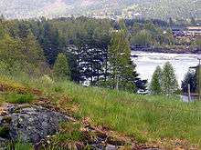
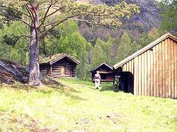 View of an open-air museum in Evje og Hornnes | |
 Coat of arms 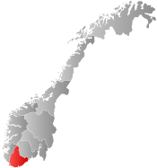 Agder within Norway | |
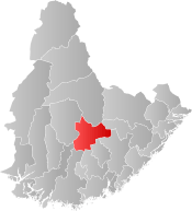 Evje og Hornnes within Agder | |
| Coordinates: 58°35′05″N 07°46′14″E | |
| Country | Norway |
| County | Agder |
| District | Setesdal |
| Administrative centre | Evje |
| Government | |
| • Mayor (1999) | Bjørn Alfred Ropstad (KrF) |
| Area | |
| • Total | 550.23 km2 (212.44 sq mi) |
| • Land | 514.72 km2 (198.73 sq mi) |
| • Water | 35.51 km2 (13.71 sq mi) |
| Area rank | 196 in Norway |
| Population (2017) | |
| • Total | 3,614 |
| • Rank | 242 in Norway |
| • Density | 7.0/km2 (18/sq mi) |
| • Change (10 years) | 9.0% |
| Demonym(s) | Evjedøl Honndøl[1] |
| Time zone | UTC+01:00 (CET) |
| • Summer (DST) | UTC+02:00 (CEST) |
| ISO 3166 code | NO-4219 |
| Official language form | Neutral[2] |
| Website | www |
The 550-square-kilometre (210 sq mi) municipality is the 196th largest by area out of the 422 municipalities in Norway. Evje og Hornnes is the 242nd most populous municipality in Norway with a population of 3,614. The municipality's population density is 7 inhabitants per square kilometre (18/sq mi) and its population has increased by 9% over the last decade.[3]
General information
.jpg)

During the 1960s, Norway enacted many municipal reforms such as mergers and border adjustments due to the work of the Schei Committee, and the municipality of Evje og Hornnes was established during this time. On 1 January 1960, the neighboring municipalities of Evje (population: 1,646) and Hornnes (population: 1,280) were merged to form Evje og Hornnes. On 1 January 1986, the Lislevand farm area (population: 8) was transferred from neighboring Birkenes municipality to Evje og Hornnes.[4] On 1 January 2019, the Hovlandsdalen area (population: 27) was transferred from neighboring Birkenes municipality to Evje og Hornnes.[5]
Name
The municipalities of Evje and Hornnes were joined in 1960 with the compound name Evje og Hornnes, literally Evje and Hornnes.
The municipality (originally the parish) of Evje is named after an old Evje farm (Old Norse: Efja), since the first Evje Church was built there. The name is identical with the word efja, which means "eddy", possibly referring to the nearby river Otra.[6]
The municipality (originally the parish) of Hornnes is named after an old Hornnes farm (Old Norse: Hornnes), since the first Hornnes Church was built there. The first element is horn, which means "horn", and the last element is nes, which means "headland". So the meaning of Hornnes is "the headland shaped like a horn". This is likely referring to the two horn-shaped peninsulas that jut out into the river Otra at the entrance to the lake Breidflå.[6]
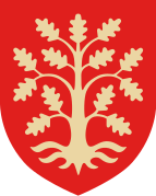
Coat of arms
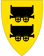
The coat of arms is from modern times; they were granted on 24 April 1992. The arms are gold with two black mining wagons in the centre, one above the other. These arms were chosen because mining has been of great importance for the area already for many centuries. One of Europe's largest nickel mines is in the municipality.[7]
Churches
The Church of Norway has two parishes (sokn) within the municipality of Evje og Hornnes. It is part of the Otredal prosti (deanery) in the Diocese of Agder og Telemark.
| Parish (Sokn) | Church name | Location of the church | Year built |
|---|---|---|---|
| Evje | Evje Church | Evje | 1891 |
| Hornnes | Hornnes Church | Hornnes | 1828 |
History
The Flåt mine in Evje og Hornnes municipality was Europe’s largest nickel mine for a period. Flåt mine came into operation in 1844 as a copper mine. From 1872 until 1946 it was mined for nickel. At the point operations were terminated, it was 422 metres (1,385 ft) deep (reaching below sea level). Over 3 million tons of ore were removed and refined into 14,500 tonnes (14,300 long tons; 16,000 short tons) of copper and 20,000 tonnes (20,000 long tons; 22,000 short tons) of nickel. Local mining technology and mine history can be seen at the museum at Fennefoss, just outside of the village of Evje.
Evjemoen was a Norwegian military camp in use from 1912 to 2002. The camp lies south of Evje, on the eastern shore of the river Otra. From 1953 to 1995, Evjemoen was used as a training area for Infanteriets øvingsavdeling II (IØ2). The camp was retired in December 2002.
Geography
Evje og Hornnes is bordered by the municipalities of Bygland and Froland to the northeast and by Birkenes and Iveland to the southeast (all in Aust-Agder county). To the west it is bounded by Åseral and Audnedal and to the south by Marnardal and Vennesla municipalities (all in Vest-Agder county).
The Otra river which flows through Evje og Hornnes is the largest river in the Sørlandet district. It flows from the Setesdalsheiene mountains to the north in Bykle municipality down to the municipality of Kristiansand in the south. The lake Kilefjorden is part of the Otra river, along the southern part of the municipality.
The lake Gyvatn is located along the border with Bygland and Åseral. The lake Høvringsvatnet is located about 10 kilometres (6.2 mi) northeast of the municipal center of Evje. The lake Byglandsfjorden has its southernmost point in the northern part of the municipality.
Government
All municipalities in Norway, including Evje og Hornnes, are responsible for primary education (through 10th grade), outpatient health services, senior-citizen services, unemployment and other social services, zoning, economic development, and municipal roads. The municipality is governed by a municipal council of elected representatives, which in turn elect a mayor.
Municipal council
The municipal council (Kommunestyre) of Evje og Hornnes is made up of 21 representatives, which are elected to every 4 years. Currently, the party breakdown is as follows:[8]
| Party Name (in Norwegian) | Number of representatives | |
|---|---|---|
| Labour Party (Arbeiderpartiet) | 6 | |
| Progress Party (Fremskrittspartiet) | 1 | |
| Conservative Party (Høyre) | 2 | |
| Christian Democratic Party (Kristelig Folkeparti) | 9 | |
| Centre Party (Senterpartiet) | 2 | |
| Liberal Party (Venstre) | 1 | |
| Total number of members: | 21 | |
Geology
The Evje og Hornnes municipality is situated at the southwestern margin of the Baltic Shield, the exposed section of the East European craton. Rocks in the area are dominated by different types of precambrian gneis and a large metagabbro body stretching into the neighboring Iveland municipality.
During the final stages of Sveconorwegian (0,9–1,1 Ga) orogeny, a large pluton of granitic/monzonitic composition was emplaced in the northern part of the municipality and is assumed to have a relationship with the thousands of pegmatite veins in the Evje-Iveland area.
Earlier during the Sveconorwegian orogeny, mafic rocks (gabbro-diorite) were emplaced. Most of the gabbro has been affected by the Sveconorwegian orogeny and became a metagabbro (amfibolite) with only minor remnants of the original gabbro. The Flåt Nickel Mine is situated at the north-western margin in a diorite intrusion post-dating the gabbro.
The pegmatites of the Evje-Iveland area have become worldwide known for a large number of rare and often crystallized minerals.
The pegmatites were initially mined for quartz, used in the melter at Fennefoss to extract the nickel from the ore from the Flåt Nickel Mine. Later, large quantities of feldspar were mined for use in the ceramic industry, both in Norway and abroad. Also mica (muscovite), beryl, rare-earth minerals, scandium ore, and minor quantities of uranium ore were mined.
After 1983, almost all mines were abandoned, and nowadays only minor quantities of "tannspat" or dentalspat are mined in a couple of mines. This is microcline or plagioclase feldspar of very high purity and used to make porcelain teeth-fillings or dentures. The tannspat is exported to Germany, Liechtenstein, Austria, and sometimes Japan.
A number of the mines is still open to mineral collectors.
Economy
The area is internationally known for its geology and its mineral richness. Deposits of nickel, quartz, feldspar, mica, beryl, REE minerals, scandium, and uranium ore have been exploited. Nowadays only ultra-pure feldspar for dental applications is being mined.
Tourism is a major source of income for the entire area. During the summer, many thousands of tourist visit Evje. Outdoor activities in the area include rafting, rock climbing, biking, cross-country skiing, kayaking, canoeing, paddling, water skiing, riverboarding, swimming, fishing, mineral collecting, and mine excursions. Additionally, there are several museums and farms open to visitors.
The shopping center of Evje is of regional importance. In addition, there is some industry in Evje. One such industry is Skibsplast, a producer of fiberglass boats.[9]
Attractions
Geology
- Geomuseum in Fennefoss
The Setesdal Museum owns the Evje og Hornnes Geomuseum på Fennesfoss, which is based out of Rysstad in Valle municipality. The geomuseum has an extensive collection of local minerals, most notably minerals from the pegmatite veins in the Evje-Iveland district. These pegmatites have been exploited for quartz, feldspar, mica, beryl, thortveitite, REE-containing minerals and uraninite. In addition, gemstone material has been found: aquamarine, gold beryl, rock crystal, smoky quartz, citrine, spessartine and amazonite. The geomuseum has samples of all these minerals. Marie Curie had several consignments of radioactive minerals sent to her from this region. The museum includes a collection of laboratory equipment, among which an electroscope with "Pierre Curie" engraved.
- Setesdal Mineralpark
The Setesdal Mineralpark is located at Auensneset, 5 kilometres (3.1 mi) south of the village of Evje. The displays are entirely constructed in underground mining adits. The collection consists of more than 1000 foreign and Norwegian minerals. The Setesdal Mineralpark is internationally acclaimed to be a unique museum, with a collection of very high quality. The Evje-Iveland district is known for its mineral richness and is yearly visited by thousands of collectors trying their luck in one of the pegmatite mines.
- Flåt nickel mine
The Flåt nickel mine is situated a couple of hundreds of meters behind the Evje Mineralsti, and has been Europe's largest nickel mine. The mine was operated from 1844 initially as a copper mine, but from 1872 to 1946 as a nickel mine. The upper parts of the Flåt Nickel Mine is open to visitors and during the summer there are daily guided tours.
- Evje mineral trail
The five pegmatite quarries at the 2 kilometres (1.2 mi) long Evje Mineralsti are accessible to collectors against a modest fee. Here it is possible to collect samples of amazonite, different types of quartz, fluorite, pyrite and many others. It is also possible to find samples of the pegmatite rock, with feldspar/quartz/mica. The first mine, Landsverk I, is also the most mineral-rich pegmatite of the entire Evje-Iveland district.
- Oddestemmen steinsliperi
The Oddestemmen Steinsliperi is probably the only remaining old-fashioned stone-cutter workshop left in Norway. The workshop specializes in the cabochon technique and produces silver jewelry with stones from own production.
- Mineral tourism
The Evje-Iveland area is famous for its mineral richness and is visited by thousands of collectors and mineral-minded people every year. In the area several of the old pegmatite mines are open to collectors on a fee-basis. During the 2008 season the following mines are open: Birkeland, Håvarstad, Knipane, Litjønn, Slobrekka, Solås, Steli (all in Iveland), and Evje Mineralsti (in Evje).
In all these mines it is possible to collect nice samples of the basic minerals: quartz, feldspar and mica. Additionally it is possible to find many other different minerals, varying from mine to mine. A valid collecting permit is necessary in order to be allowed to collect minerals at these places. It is not allowed to collect in any of the other mines without prior, explicit permission of the owner of the mine.
Byglandsfjorden
The Byglandsfjorden is a large inland lake 40 kilometres (25 mi) in length situated in the Bygland municipality, just north of the Evje og Hornnes municipality. It is part of the Otra river. The lake provides swimming and fishing opportunities.
The only wood-burning steamboat in the country, the "Bjoren", provides tourist trips on Byglandsfjorden. It was built in 1866.
Otra
The Otra river is the largest river in the south of Norway. It springs from the Setesdalsheiene in the Bykle municipality in the Aust-Agder county and runs southwards to Kristiansand in the Vest-Agder county, where it runs out in the sea. The Otra is known for salmon fishing all the way up to Vigeland in the Vennesla municipality. The Byglandsfjord is known for a rare salmon variety, the "bleka" or "bleke". The Otra is extensively used for outdoor activities, like rafting, paddling, swimming and fishing.
References
- "Navn på steder og personer: Innbyggjarnamn" (in Norwegian). Språkrådet.
- "Forskrift om målvedtak i kommunar og fylkeskommunar" (in Norwegian). Lovdata.no.
- Statistisk sentralbyrå (2017). "Table: 06913: Population 1 January and population changes during the calendar year (M)" (in Norwegian). Retrieved 2017-11-05.
- Jukvam, Dag (1999). "Historisk oversikt over endringer i kommune- og fylkesinndelingen" (PDF) (in Norwegian). Statistisk sentralbyrå.
- "Vedtak om endring av kommunegrense – overføring av Hovlandsdalen fra Birkenes kommune til Evje og Hornnes kommune, Aust-Agder fylke" (PDF) (in Norwegian). Fylkesmannen i Aust- og Vest-Agder. 2018-03-21.
- Rygh, Oluf (1905). Norske gaardnavne: Nedenes amt (in Norwegian) (8 ed.). Kristiania, Norge: W. C. Fabritius & sønners bogtrikkeri. pp. 184 and 191.
- "Civic heraldry of Norway - Norske Kommunevåpen". Heraldry of the World. Retrieved 2017-05-30.
- "Table: 04813: Members of the local councils, by party/electoral list at the Municipal Council election (M)" (in Norwegian). Statistics Norway. 2015.
- http://www.skibsplast.no/
External links
| Wikimedia Commons has media related to Evje og Hornnes. |
| Look up Evje og Hornnes in Wiktionary, the free dictionary. |
- Evje og Hornnes www.visitnorway.com (in English)
- Municipal fact sheet from Statistics Norway (in Norwegian)

- Municipal website (in Norwegian)
- Setesdal.com (in Norwegian)
- Kultur i Evje og Hornnes på kart (map) (in Norwegian)
- Evje og Hornnes Geomuseum på Fennefoss (in Norwegian)
- Iveland Kommunehus (in Norwegian)
- Setesdal Mineralpark (in Norwegian)
 |  | ||||||||||||||||||||
|