Valle, Norway
Valle (Urban East Norwegian: [ˈvɑ̂lːə] (![]()
Valle kommune | |
|---|---|
 View of the Rygnestadloftet at the Rygnestadtunet museum | |
 Coat of arms 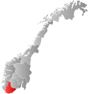 Agder within Norway | |
 Valle within Agder | |
| Coordinates: 59.2125°N 07.5358°E | |
| Country | Norway |
| County | Agder |
| District | Setesdal |
| Administrative centre | Valle |
| Government | |
| • Mayor (2015) | Steinar Kyrvestad (Ap) |
| Area | |
| • Total | 1,265.31 km2 (488.54 sq mi) |
| • Land | 1,129.86 km2 (436.24 sq mi) |
| • Water | 135.45 km2 (52.30 sq mi) |
| Area rank | 75 in Norway |
| Population (2017) | |
| • Total | 1,246 |
| • Rank | 374 in Norway |
| • Density | 1.1/km2 (3/sq mi) |
| • Change (10 years) | -5.6% |
| Demonym(s) | Valldøl[1] |
| Time zone | UTC+01:00 (CET) |
| • Summer (DST) | UTC+02:00 (CEST) |
| ISO 3166 code | NO-4221 |
| Official language form | Nynorsk[2] |
| Website | www |
The 1,265-square-kilometre (488 sq mi) municipality is the 75th largest by area out of the 422 municipalities in Norway. Valle is the 374th most populous municipality in Norway with a population of 1,246. The municipality's population density is 1.1 inhabitants per square kilometre (2.8/sq mi) and its population has decreased by 5.6% over the last decade.[4]
General information

Valle was established as a municipality on 1 January 1838 (see formannskapsdistrikt). On 1 January 1902, the northern part of Valle (population: 476) was separated to become the separate municipality of Bykle. This left Valle with 1,720 inhabitants. On 1 July 1915, the southern district of Valle (population: 658) was separated to form the new municipality of Hylestad. This left Valle with a population of 1,051. During the 1960s, there were many municipal mergers across Norway due to the work of the Schei Committee. On 1 January 1962, the municipalities of Hylestad (population: 662) and Valle (population: 902) were merged into one municipality named Valle.[5]
Name
The municipality (originally the parish) is named after the old Valle farm (Old Norse: Vǫllr), since the first Valle Church was built there. The form of the name is the genitive case, from the common expressions Vallar kirkja (church) and Vallar sókn (parish).[6]
Coat-of-arms
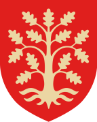
The coat-of-arms is from modern times; they were granted on 11 May 1984. The arms are red and they show five Saint Andrew's crosses in the pattern 2-1-2, together forming a larger cross. The composition was based on the decoration in the medieval Hylestad Stave Church, located in Rysstad. This pattern is also used in traditional clothes made in the municipality.[7]
Churches
The Church of Norway has one parish (sokn) within the municipality of Valle. It is part of the Otredal prosti (deanery) in the Diocese of Agder og Telemark.
| Parish (Sokn) | Church Name | Location of the Church | Year Built |
|---|---|---|---|
| Valle og Hylestad | Hylestad Church | Rysstad | 1838 |
| Valle Church | Valle | 1844 |
Geography
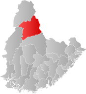
The municipality of Valle is bordered to the north by the municipalities of Bykle (in Aust-Agder county) and Tokke (in Telemark county). To the east, it is bordered by Fyresdal municipality in Telemark, to the south it is bordered by Bygland municipality in Aust-Agder, and to the west it is bordered by Sirdal municipality in Vest-Agder county.
Valle lies in the middle of Setesdal, a valley and a traditional district in Aust-Agder that included the municipalities of Bykle, Valle, Bygland, Iveland, and Evje og Hornnes. The Otra river flows from the Hardangervidda plateau in Telemark to the north, through the Setesdal valley (and through Valle), into the sea near the city of Kristiansand.
 View of the area near Brokkestøyl
.jpg) Farmhouse near the lake Mykelvatnet
Farmhouse near the lake Mykelvatnet View of the Veiåjuvet canyon
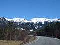 View of the Rv9 road
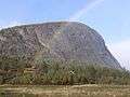
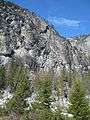 Evangsnuten mountain
Valle is separated from the neighbouring valleys in the east and west by the large Setesdalsheiene mountain plateaus. Before the valley was linked by road to Kristiansand in the 1840s, people routinely traveled east and west across these moorlands. The highest point is the 1,418-metre (4,652 ft) tall Skammevarden. Other high mountains in Valle include Bergeheii, Skjerkenuten, Svarvarnuten, and Urddalsknuten.
The high mountains are the starting points for several large rivers including the Kvina and Tovdalselva. Several large lakes are also located in Valle including Botnsvatnet, Kolsvatnet, Rosskreppfjorden, Store Bjørnevatn, Straumsfjorden, and Øyarvatnet. The Hallandsfossen and the Gloppefossen are two larger waterfalls in Valle.
There are two central population centres in the municipality: Valle and Rysstad. The village of Valle is the site of the municipal administration and Rysstad was the site of the municipal administration in the old municipality of Hylestad.
History

The Hylestad stave church, constructed in the 12th century in Setesdal was demolished in the 19th century. Its portal, with several carved scenes illustrating the legend of Sigurd Fåvnesbane (Sigurd the Dragon-slayer), is on display at University Museum of Antiquities in Oslo (Universitetets Oldsaksamling, Historisk Museum, Oslo). Sigurd's slaying of Fafnir with his sword Gram is described in the Prose Edda of Snorri Sturluson and the Volsunga saga as well as alluded to in Beowulf and Njáls saga.[8]
Rygnestadtunet is a historical family farm in Rygnestad, built by Vonde-Åsmund (Åsmund the Evil) in the mid-1500s. Today, it is an open-air museum that is part of the Setesdal Museum. The farm was sold to museum by Gyro Rygnestad and her family in the 1920s. Today, it is represented to visitors exactly as it was in 1919. Grave findings around the farm indicate that the site was settled as early as 900 AD. Another farm museum in Valle is Tveitetunet. There are also several old silver smithies and barns that can be seen in Rysstad.
Historically, Valle was very isolated from other parts of Setesdal. To get from Valle to the Bykle area to the north, residents had to traverse the Byklestigen pass along the river Otra. The pass was a torturous trail up a steep cliff face. Until the 1870s, it was the only route to travel from Valle in the middle Setesdal valley to Bykle in the north. It runs above the river Otra and was the site of numerous accidents on the hazardous route. Today, the Norwegian National Road 9 passes through the mountain in a tunnel providing a fast, easy route north.
Between Valle in Setesdal on the western side of the mountains and Fyresdal on the eastern side, one finds a medieval trail over the high plateau that priests and bishops used in order to get between the counties of Agder and Telemark. This track is named Bispevegen ("Bishop's Road") and every year a march called "Bispevegmarsjen" ("The Bishop's Road March") starts at Kleivgrend in Fyresdal.
Traditional music is popular in this region. There is a Jew's harp monument in Valle. (Photo)
Government
All municipalities in Norway, including Valle, are responsible for primary education (through 10th grade), outpatient health services, senior citizen services, unemployment and other social services, zoning, economic development, and municipal roads. The municipality is governed by a municipal council of elected representatives, which in turn elect a mayor.
Municipal council
The municipal council (Kommunestyre) of Valle is made up of 15 representatives that are elected to four-year terms. Currently, the party breakdown is as follows:[9]
| Party Name (in Nynorsk) | Number of representatives | |
|---|---|---|
| Labour Party (Arbeidarpartiet) | 7 | |
| Conservative Party (Høgre) | 2 | |
| Centre Party (Senterpartiet) | 4 | |
| Liberal Party (Venstre) | 2 | |
| Total number of members: | 15 | |
Politics
In the 2007 municipal elections, Valle recorded the highest vote for the Conservative Party in Norway at 48.9 per cent.
Notable residents
- Kirsten Bråten Berg, a folksinger and silversmith
- Paal-Helge Haugen, an author
- Josh Homme, the frontman of hard rock band Queens of the Stone Age, has ancestral roots from Valle
References
- "Navn på steder og personer: Innbyggjarnamn" (in Norwegian). Språkrådet.
- "Forskrift om målvedtak i kommunar og fylkeskommunar" (in Norwegian). Lovdata.no.
- Berulfsen, Bjarne (1969). Norsk Uttaleordbok (in Norwegian). Oslo: H. Aschehoug & Co (W Nygaard). p. 351.
- Statistisk sentralbyrå (2017). "Table: 06913: Population 1 January and population changes during the calendar year (M)" (in Norwegian). Archived from the original on 9 June 2016. Retrieved 5 November 2017.
- Jukvam, Dag (1999). "Historisk oversikt over endringer i kommune- og fylkesinndelingen" (PDF) (in Norwegian). Statistisk sentralbyrå. Archived (PDF) from the original on 3 October 2013. Retrieved 16 April 2017.
- Rygh, Oluf (1905). Norske gaardnavne: Nedenes amt (in Norwegian) (8 ed.). Kristiania, Norge: W. C. Fabritius & sønners bogtrikkeri. Archived from the original on 30 December 2011. Retrieved 4 November 2016.
- "Civic heraldry of Norway – Norske Kommunevåpen". Heraldry of the World. Archived from the original on 16 April 2017. Retrieved 15 April 2017.
- Haimerl, Edgar. "Sigurd—ein Held des Mittelalters" (PDF) (in German). Archived (PDF) from the original on 29 June 2011. Retrieved 5 March 2011.
- "Table: 04813: Members of the local councils, by party/electoral list at the Municipal Council election (M)" (in Norwegian). Statistics Norway. 2015. Archived from the original on 6 March 2016. Retrieved 16 April 2017.
External links
| Wikimedia Commons has media related to Valle. |
| Look up Valle in Wiktionary, the free dictionary. |
- Municipal fact sheet from Statistics Norway (in Norwegian)

- Valle municipality (in Norwegian)
- Otra Kraft (in Norwegian)
- Culture in Valle on the map (in Norwegian)
- Map hiking (in German)
 |  | ||||||||||||||||||||
|