Timaru
Timaru (English: /ˈtɪməˌruː/;[2] Māori: Te Tihi-o-Maru) is a port city in the southern Canterbury region of New Zealand, located 157 kilometres (98 mi) southwest of Christchurch and about 196 kilometres (122 mi) northeast of Dunedin on the eastern Pacific coast of the South Island. The Timaru urban area is home to 28,300 people, and is the largest urban area in South Canterbury, and the second largest in the Canterbury Region overall, after Christchurch.[1] The town is the seat of the Timaru District, which includes the surrounding rural area and the towns of Geraldine, Pleasant Point and Temuka, which combined have a total population of 47,900.[1]
Timaru | |
|---|---|
City | |
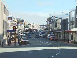 View down Stafford Street in 2006 | |
 Timaru | |
| Coordinates: 44°24′S 171°15′E | |
| Country | New Zealand |
| Region | Canterbury |
| Territorial authority | Timaru District |
| Government | |
| • Mayor | Nigel Bowen |
| Area | |
| • Land | 2,736.54 km2 (1,056.58 sq mi) |
| Highest elevation | 95 m (312 ft) |
| Lowest elevation | 0 m (0 ft) |
| Population (June 2019)[1] | |
| • Urban | 28,300 |
| Time zone | UTC+12 (New Zealand Standard Time) |
| • Summer (DST) | UTC+13 (New Zealand Daylight Time) |
| Postcode | 7910 |
| Local iwi | Ngāi Tahu |
| Website | timaru.govt.nz |
Caroline Bay beach is a popular recreational area located close to Timaru's main centre, just to the north of the substantial port facilities. Beyond Caroline Bay, the industrial suburb of Washdyke is at a major junction with State Highway 8, the main route into the Mackenzie Country. This provides a road link to Pleasant Point, Fairlie, Twizel, Lake Tekapo, Aoraki / Mount Cook and Queenstown.
Timaru has been built on rolling hills created from the lava flows of the extinct Mt Horrible volcano, which last erupted thousands of years ago. The result is that most of the main streets are undulating, a clear contrast with the flat landscape of the Canterbury Plains to the north. This volcanic rock is used for the construction of local "bluestone" buildings.
History
Māori settlement
The origin of the name 'Timaru' is disputed . Some believe that it derives from Māori Te Maru, which can mean a 'place of shelter'. However, other authorities allege that Timaru originates from a literal translation of the combination of ti, a cabbage tree and maru, meaning 'shady'.[3]
Māori waka seem to have employed the site of Timaru as a place to rest on journeys up and down the eastern coastline for many years before the arrival of the first Europeans in the 19th century. The area includes over 500 sites with traces of Māori rock art, particularly in the rock overhangs and caves of the Opuha and Opihi river valleys, to the west of modern-day Timaru. Archaeologists have suggested that Māori iwi (tribes) were permanently settled in the district before 1400 AD. During the 17th or 18th century the resident Ngāti Mamoe were driven southwards into Fiordland by an invasion of the Ngāi Tahu, who came from the North Island.
19th century onwards
European settlement began with the construction of a whaling station in 1839 by the Weller brothers of Otago at Patiti Point, close to the present town centre.[4] A supply ship, The Caroline, provided the name for a local bay. Later a sheep station, known as The Levels, was set up on land obtained by the Rhodes brothers, and run by George Rhodes.[5][6] One of the earliest settlers was Captain Henry Cain, who set up a store in 1857 on behalf of Henry Le Cren of Lyttelton, and Le Cren himself moved to Timaru in the following year.[7]
Few lived in Timaru until 1859 when the ship SS Strathallan arrived from England, carrying a party of 120 immigrants.[8] Persistent land disputes arose between the Rhodes brothers and local government officials with the result that two townships were established in the port area, Government Town and Rhodestown. These eventually merged into a single community in 1868. Given this division, until recently none of the main north-south streets lined up. Stafford Street, which became the main thoroughfare, was formed along the early bullock wagon trail.
Following the loss of a number of vessels off the coast, the breakwater design by Engineer John Goodall was adopted and work started on the redevelopment of the artificial port in 1877[9] , which eventually caused sand washed south down the Pacific shoreline to build up against the northern mole. This was the beginning of the extensive land reclamation around the Caroline Bay district, an area which is still growing today.
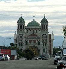
Timaru continued to expand during the 20th century, with much of the development taking the form of wooden colonial style bungalows set in individual sections of land. Sacred Heart Basilica was opened in 1911.
Location
Timaru is situated along the Pacific Ocean coast. Much of the hinterland is farmland. To the north and northeast are the Canterbury Plains.
Neighbouring cities, towns and places. | ||||||||||
|---|---|---|---|---|---|---|---|---|---|---|
| ||||||||||
Climate
Timaru has a relatively dry temperate climate similar to that of neighbouring Ashburton and Christchurch, classified as oceanic climate (Cfb)[10] by Köppen-Geiger climate classification system. Temperatures are warm in summer and cold in winter, with Timaru's extreme maximum temperature being 41.3 °C on 6 February 2011[11] and extreme minimum temperature of −9.1 °C on 3 August 1998.[12] Rain is evenly distributed throughout the year, with a very small proportion of it falling as snow.
| Climate data for Timaru (1981–2010) | |||||||||||||
|---|---|---|---|---|---|---|---|---|---|---|---|---|---|
| Month | Jan | Feb | Mar | Apr | May | Jun | Jul | Aug | Sep | Oct | Nov | Dec | Year |
| Average high °C (°F) | 21.5 (70.7) |
20.8 (69.4) |
19.5 (67.1) |
16.8 (62.2) |
13.7 (56.7) |
11.3 (52.3) |
10.6 (51.1) |
12.1 (53.8) |
14.5 (58.1) |
16.2 (61.2) |
18.0 (64.4) |
19.7 (67.5) |
16.2 (61.2) |
| Daily mean °C (°F) | 15.9 (60.6) |
15.5 (59.9) |
13.8 (56.8) |
11.0 (51.8) |
8.1 (46.6) |
5.6 (42.1) |
5.0 (41.0) |
6.5 (43.7) |
8.7 (47.7) |
10.4 (50.7) |
12.3 (54.1) |
14.4 (57.9) |
10.6 (51.1) |
| Average low °C (°F) | 10.3 (50.5) |
10.1 (50.2) |
8.2 (46.8) |
5.1 (41.2) |
2.5 (36.5) |
−0.2 (31.6) |
−0.6 (30.9) |
0.8 (33.4) |
2.8 (37.0) |
4.7 (40.5) |
6.6 (43.9) |
9.1 (48.4) |
4.9 (40.8) |
| Average precipitation mm (inches) | 46.5 (1.83) |
51.7 (2.04) |
47.6 (1.87) |
38.7 (1.52) |
46.6 (1.83) |
38.8 (1.53) |
46.2 (1.82) |
43.8 (1.72) |
36.5 (1.44) |
49.5 (1.95) |
49.6 (1.95) |
52.8 (2.08) |
546.8 (21.53) |
| Average precipitation days (≥ 1.0 mm) | 6.8 | 6.7 | 6.2 | 5.7 | 5.7 | 5.3 | 5.8 | 5.7 | 5.8 | 7.1 | 6.8 | 8.0 | 75.6 |
| Average relative humidity (%) | 77.7 | 83.5 | 83.8 | 85.4 | 85.6 | 85.0 | 85.4 | 83.7 | 78.7 | 77.3 | 75.2 | 76.3 | 81.5 |
| Mean monthly sunshine hours | 192.7 | 170.2 | 168.6 | 158.0 | 130.1 | 121.0 | 131.0 | 151.5 | 156.5 | 183.4 | 189.0 | 179.7 | 1,931.9 |
| Source: NIWA Climate Data[13] | |||||||||||||
Climate-Data.org gives slightly warmer averages.[10]
| Climate data for Timaru | |||||||||||||
|---|---|---|---|---|---|---|---|---|---|---|---|---|---|
| Month | Jan | Feb | Mar | Apr | May | Jun | Jul | Aug | Sep | Oct | Nov | Dec | Year |
| Average high °C (°F) | 21.2 (70.2) |
21.1 (70.0) |
19.4 (66.9) |
16.8 (62.2) |
13.4 (56.1) |
10.6 (51.1) |
10.2 (50.4) |
11.6 (52.9) |
14.2 (57.6) |
16.1 (61.0) |
18.3 (64.9) |
20 (68) |
16.1 (60.9) |
| Daily mean °C (°F) | 16.4 (61.5) |
16.3 (61.3) |
14.8 (58.6) |
12.1 (53.8) |
8.8 (47.8) |
6 (43) |
5.7 (42.3) |
7 (45) |
9.4 (48.9) |
11.4 (52.5) |
13.4 (56.1) |
15.3 (59.5) |
11.4 (52.5) |
| Average low °C (°F) | 11.6 (52.9) |
11.5 (52.7) |
10.2 (50.4) |
7.4 (45.3) |
4.2 (39.6) |
1.5 (34.7) |
1.3 (34.3) |
2.5 (36.5) |
4.7 (40.5) |
6.7 (44.1) |
8.6 (47.5) |
10.6 (51.1) |
6.7 (44.1) |
| Average precipitation mm (inches) | 54 (2.1) |
49 (1.9) |
59 (2.3) |
56 (2.2) |
52 (2.0) |
38 (1.5) |
48 (1.9) |
47 (1.9) |
33 (1.3) |
49 (1.9) |
52 (2.0) |
50 (2.0) |
587 (23) |
| Source: Climate-Data.org (altitude: 22m)[10] | |||||||||||||
Government

The mayor of Timaru District is Nigel Bowen.
Timaru is part of the parliamentary electorate of Rangitata, represented by Andrew Falloon of the New Zealand National Party.
Sister cities
Timaru District has established four sister city relationships.[14]
.svg.png)


Economy
Timaru is an agricultural service town and port for the South Canterbury regional economy.[15] Timaru is one of the major cargo ports of the South Island, with a number of light manufacturing plants associated with the export and import trade. Many of these producers are concerned with processing, packing, and distributing meat, dairy and other agricultural produce.
Timaru is the second largest fishing port in New Zealand.
Allan Hubbard the chartered accountant and philanthropist established the failed finance company South Canterbury Finance and accounting firm Hubbard Churcher in Timaru and lived locally until his death in a car accident on 2 September 2011.[16]
Transport
Timaru is on State Highway 1 (SH1), the main road route down the eastern coast of the South Island.
There are regular coach and minibus services to Christchurch, Dunedin, Invercargill, Queenstown and the Mackenzie Country, leaving from outside the Visitor Information Centre, which provides booking facilities and other travel services.
The Main South Line section of the South Island Main Trunk Railway runs through Timaru and is a significant freight corridor. Passenger rail services were discontinued after the cancellation of the Southerner in February 2002. Between 1949 and 1970, Timaru was serviced by the South Island Limited, one of the former New Zealand Railways Department's most prestigious trains.
Richard Pearse Airport is to the north of the town. It is equipped to handle light aircraft and short haul domestic flights, with regular services to Wellington
A regular bus service known as “Timaru Link” runs Monday-Saturday connecting major parts of Timaru as well as an on demand bus service known as “MyWay” running daily
Education
Further information: List of schools in Canterbury, New Zealand
Primary
- Barton Rural Primary School (previously Fairview)
- Beaconsfield Primary School (previously Pareora West)
- Bluestone Primary School (previously West School)
- Gleniti Primary School
- Grantlea Downs (previously Grantlea)
- Highfield Primary School
- Oceanview Heights Primary School (previously Marchwiel School)
- Sacred Heart Primary
- St. Josephs School
- Timaru Christian School
- Timaru South School
- Waimataitai Primary School
Secondary
- Aoraki Alternative Education Center
- Craighead Diocesan School
- Mountainview High School
- Roncalli College
- Timaru Boys' High School
- Timaru Girls' High School
Tertiary
Shopping
Retailing is concentrated around the Stafford Street area. In addition there are a number of local shopping malls distributed around the city, with extensive car parking facilities.
Tourist attractions
The South Canterbury Museum is the main museum for the region, containing exhibits relating to physical geography and the environment, fossil remains, Māori rock art, the early settlement of the district, local maritime history, scrimshaw, the E P Seally natural history collection, and information about Richard Pearse, a local inventor and his attempts at manned flight in the first years of the 20th century.
The Aigantighe (a Scots Gaelic word pronounced "egg and tie") Art Gallery in Wai-iti Road is the South Island's third largest art museum. It holds a collection of New Zealand, Pacific, Asian and European art works from the sixteenth century to the present day and includes a sculpture garden. The gallery was founded in 1956 and is housed in a homestead built in 1908.
Timaru has with a number of open spaces, public gardens and parks. The Trevor Griffiths Rose Garden at Caroline Bay Park[17] is a major feature of the Timaru Piazza development. The parkland of the Bay Area contains a mini golf course, a roller skating rink, a maze and staging for musical events. It is home to the annual Summer Carnival that takes place over the Christmas and New Year holiday period. To the south of the city centre are the Timaru Botanic Gardens, first laid out in 1864, with a notable collection of roses and native tree ferns. To the west is the Centennial Park Reserve, opened in 1940, that includes a tranquil 3.5 km walkway following the wooded valley of the Otipua Creek.
The DB Mainland Brewery in Sheffield Street offers tours and tasting sessions.
The Caroline Bay Carnival, featuring live performances, games, and side shows, takes place from Boxing Day through to mid-January at Caroline Bay Park.[18]
Aoraki Tourism is the official tourism body for the whole Timaru District.[19]
Media
Print
The Timaru Herald is the local daily newspaper for the district and has been published since the mid nineteenth century. Papers are printed in Ashburton and then distributed throughout the Otago and South Canterbury region. The Herald is owned by Fairfax New Zealand. The High Country Herald, also published by Fairfax New Zealand, has a circulation of 43,000 copies.[20]
The region also supports a weekly community newspaper, The Timaru Courier, which has a circulation of over 24,000 copies and is delivered free every Thursday to local households. The Courier is owned by Allied Press of Dunedin.
Radio
Timaru has one local FM radio station 100.3FM South Canterbury. There are also many networked FM radio stations, and a volunteer-run Hospital Radio 88.0/107.5 which celebrated its 30th anniversary in 2019.[21]
Notable residents
Academics
- Hugh D. Wilson, botanist
Business
- Henry Le Cren, Timaru pioneer and first Pakeha trader[7]
- Fulbert Archer, of the merchant house Miles Archer and Co 1867–1893; first Chairman of the Timaru Harbour Board [22][23]
Politics
- James Craigie, politician
- Basil Arthur, politician
- Jo Goodhew, politician
- Jim Sutton, politician
Film and television
- Kevin Smith, actor
- Phillip Leishman, broadcaster[24]
Journalism
- Allen Curnow, poet and journalist
- John Hardcastle, journalist and amateur scientist
Medicine
- Edith Tennent, nurse and Matron of Dunedin Hospital, born in Timaru
Music
- Peter Dawkins, Record producer and musician
- Michael Houstoun, concert pianist
Art
- Rosemary Campbell, painter
- Betty Curnow, painter and printmarker
Religious leaders
- Reginald Delargey, Roman Catholic cardinal
Aviation
- Richard Pearse, farmer, inventor and pioneering aviator
Sports
- Uini Atonio, professional rugby player, French international
- Hamish Bennett, cricketer, former Black Cap
- Craig Cumming, former Black Cap cricketer, sports broadcaster
- Bob Fitzsimmons, World Heavyweight Champion from 17 March 1897 until 9 June 1899
- Ross Gillespie New Zealand Olympic field hockey representative
- Tony Lamborn, Professional rugby player, USA international
- Brendan Laney, former professional rugby player, sports broadcaster
- Danyon Loader, men's swimming Olympic champion, born in Timaru
- Jack Lovelock, New Zealand runner, 1936 Olympic 1500m champion, world mile record holder
- Hayden Paddon, rally driver, 2011 Production World Rally Championship champion
- Mark Moreton Parker, NZ cricketer
- Murray Parker, NZ cricketer
- Aki Seiuli, NZ Rugby Player, Otago, Glasgow Warriors
- Haidee Tiffen, NZ women's cricketer
- John Ward, NZ cricketer
- Tomas Walsh, NZ shotputter
Recreation and leisure
Performing arts
The Theatre Royal at 118 Stafford Street is home of much of Timaru's live entertainment.
Public libraries
The Timaru District Library has branches situated in Timaru, Temuka and Geraldine.
The first Reading Room was opened in the School House, Barnard Street in 1862. It was open daily from 5.00pm – 10.00pm and on Saturdays 10.00am – 8.00pm. English and Colonial Newspapers were provided and a selection of Library Books for the use by members. In 1870 the Mechanics Institute was created by an addition on an existing building and aimed to provide a Library, Reading Room and News Room.
Timaru Public Library was officially opened in 1909 on the present Timaru District Council site. It was a Carnegie library, built with a 3,000 pound grant from Andrew Carnegie of New York – the condition under which the money was given was that the reading rooms should be open to everyone and that the lending Library should be free to ratepayers of the borough. The current library was opened on Sophia Street by the roundabout in 1979. It was designed by Miles, Warren and Mahoney.[25]
Sports
Sporting venues
Timaru has a comprehensive range of community sporting facilities designed to international standards for rugby, tennis, yachting, Hardcourt Bike Polo, swimming, netball, motor racing, cricket, golf, hockey, croquet, pistol shooting, trap shooting and bowls. Aorangi Park is Timaru's major sporting venue. The Council also operates the CBAY Complex which includes upgrades to the old swimming pool, a restaurant and gym. Timaru is also home to the Timaru International Motor Raceway, which is one of only 4 permanent sealed motor racing circuits in the South island.
Football
Timaru's main football ground is Sir Basil Arthur Park. It has four senior pitches and six junior pitches. Football is also played at The Caledonian Grounds, Anzac Square, West End Park, Aorangi Park and Marchwiel Park. Clubs include West End AFC, Northern Hearts, Timaru City, Timaru Thistle and Pleasant Point.
Golf
Timaru has many golf clubs and well-maintained golf courses, including:
- Highfield Golf Club
- Gleniti Golf Club
- Timaru Golf Club
and in close proximity to these:
- Pleasant Point Golf Club
- St. Andrews Golf Club
- Maungati Golf Club (9 holes)
- Temuka Golf Club
Rugby
- South Canterbury Rugby Football Union is based in Timaru. Alpine Energy Stadium is the home of local rugby.
- In the wake of the February 2011 Christchurch earthquake, the Super Rugby team, the Crusaders, moved two seasonal games to Timaru.[26]
Surfing
- Patiti Point, near Timaru city, has a left-hand reef break, which operates very consistently in any swell from the east or south.
- Jack's Point (3 km south of Timaru) has both left and right-hand reef breaks at high tide, as does Lighthouse Reef, a short walk to the south. Southerly swells produce super-heavyweight monster breakers along the Timaru coast, which are only suitable for top-gun surfers.
Inline speed skating
Timaru has New Zealand's largest Inline speed skating teams, South Canterbury, which has national records in several disciplines. The club has held many national tournaments over the years and holds the annual tour of Timaru.
Suburbs
- Washdyke
- Smithfield
- Grantlea
- Waimataitai
- Marchwiel
- Caroline Bay
- Maori Hill
- Highfield
- Glenwood
- Gleniti
- Seaview
- West End
- Watlington
- Parkside
- Kensington
- Redruth
- Oceanview
- Port Timaru
See also
References
- "Subnational Population Estimates: At 30 June 2019". Statistics New Zealand. 22 October 2019. Retrieved 11 January 2020.
- "the definition of Timaru".
- "Timaru". Research and Publishing Group of the New Zealand Ministry for Culture and Heritage. Retrieved 15 November 2019.
- Entwisle, Peter (2010). Behold the Moon: The European Occupation of the Dunedin District 1770–1848. Port Daniel Press. p. 126. ISBN 978-0-473-17534-4.
- Pinney, Robert. "George Rhodes". Dictionary of New Zealand Biography. Ministry for Culture and Heritage. Retrieved 23 April 2017.
- Cyclopedia Company Limited (1903). "Timaru". The Cyclopedia of New Zealand : Canterbury Provincial District. Christchurch: The Cyclopedia of New Zealand. Retrieved 22 August 2015.
- Pinney, Robert. "Le Cren, Frederic and Le Cren, Henry John". Dictionary of New Zealand Biography. Ministry for Culture and Heritage. Retrieved 16 August 2015.
- "Strathallan". Rootsweb. Retrieved 15 August 2015.
- Cyclopedia Company Limited (1903). "Timaru Harbour". The Cyclopedia of New Zealand : Canterbury Provincial District. Christchurch: The Cyclopedia of New Zealand. Retrieved 15 November 2019.
- "Climate: Timaru – Climate graph, Temperature graph, Climate table". Climate-Data.org. Retrieved 20 January 2014.
- 2 March 2011, 2:19 pm Press Release: NIWA (2 March 2011). "Climate Summary – February 2011: A tale of two islands | Scoop News". Scoop.co.nz. Retrieved 6 January 2012.
- "Timaru weather forecast – current temperature – local weather". Weatherzone.co.nz. Retrieved 6 January 2012.
- "Climate Data and Activities". NIWA. Retrieved 22 May 2014.
- "Sister Cities". Timary District Council. Retrieved 28 February 2019.
- McKinnon, Malcolm (26 November 2010). "2. Development of regional economies, 1850 to 1920 – Regional economies". Te Ara: The Encyclopedia of New Zealand. Retrieved 18 June 2012.
Timaru, Oamaru, Dunedin (with Port Chalmers) and Invercargill (with Bluff) were all agricultural service towns with ports for their regional economies
- Leask, Anna (3 September 2011). "Hubbard dies after crash". New Zealand Herald. Retrieved 3 September 2011.
- Caroline Bay,
- "Caroline Bay Carnival". Carolinebay.org.nz. Retrieved 6 January 2012.
- "Aoraki Tourism Website". Aoraki Tourism. Retrieved 25 May 2017.
- "High Country Herald". Fairfax New Zealand. Archived from the original on 14 October 2008. Retrieved 29 January 2009.
- Holden, Joanne (26 March 2019). "Timaru's Hospital Radio celebrates 30 years of 'better health through better music'". Stuff. Retrieved 27 April 2019.
- Papers Past. "Papers Past | SIR GEORGE GREY'S VISIT. (Timaru Herald, 1878-03-15)". Paperspast.natlib.govt.nz. Retrieved 20 September 2017.
- https://paperspast.natlib.govt.nz/newspapers/HBH18950121.2.10?query=%22miles%20and%20co%22%20extensive%20trade
- "Veteran broadcaster Phillip Leishman dies". Timaru Herald. 26 February 2013.
- "Timaru Library History". Timaru District Council. Archived from the original on 16 December 2008. Retrieved 5 August 2009.
- "Timaru crowd flock to game". Stuff.co.nz. 11 April 2011. Retrieved 22 November 2011.
Further reading
- James Belich, Russell Brown, and Martin Robinson (2004) New Zealand, Lonely Planet Series
- Darroch Donald (2003) New Zealand, 2nd Edition, Footprint Guide Series.
- Laura Harper, Tony Mudd and Paul Whitfield (2000) The Rough Guide to New Zealand, Rough Guide Series
- Mark Lawson (1993) The Battle for Room Service: Journeys to all the safe places
External links
| Wikivoyage has a travel guide for Timaru. |
| Wikimedia Commons has media related to Timaru. |
- . Encyclopædia Britannica. 26 (11th ed.). 1911.
- Timaru District Council
- Tourist information
- Timaru District Library
- South Canterbury Museum
- Historic images of Timaru from the collection of the Museum of New Zealand Te Papa Tongarewa
| Authority control |
|
|---|