Rural Municipality of Piney
The Rural Municipality of Piney is a rural municipality in southeastern Manitoba, Canada, along the border with Minnesota in the United States. The population was 1,755 at the 2006 census.
Rural Municipality of Piney, Manitoba | |
|---|---|
| Area | |
| • Land | 2,433.77 km2 (939.68 sq mi) |
| Population (2006) | |
| • Urban | 1,755 |
| • Urban density | 0.7/km2 (2/sq mi) |
| Area code(s) | 204 |
Geography
According to Statistics Canada, the municipality has a land area of 2,433.77 km². It is bordered by the rural municipalities of Stuartburn, La Broquerie, and Reynolds, as well as the Buffalo Point 36 Indian reserve and an unorganized part of the province (Division No. 1, Unorganized, Manitoba). It also borders Roseau County, Minnesota in the United States.
A minority but large part of Sandilands Provincial Forest is located here, as is a small part of Northwest Angle Provincial Forest. Also, Cat Hills Provincial Forest (49°04′28″N 95°42′58″W) and Wampum Provincial Forest (49°01′50″N 95°50′01″W) are both entirely located here, but these two forests are relatively tiny in size.
Communities
- Badger
- Carrick
- Menisino
- Middlebro
- Piney
- St. Labre
- Sandilands
- South Junction
- Sprague
- Vassar
- Wampum
- Woodridge
Adjacent rural municipalities and counties
- Rural Municipality of Stuartburn - (west)
- Rural Municipality of La Broquerie - (northwest)
- Rural Municipality of Reynolds - (north)
- Division No. 1, Unorganized, Manitoba - (northeast, east)
- Buffalo Point 36 Indian Reserve - (east)
- Lake of the Woods County, Minnesota - (southeast)
- Roseau County, Minnesota - (south)
Demographics
As of the census of 2001, there were 1685 people, 695 households, and 485 families residing in the municipality. The population density was 0.7/km². There were 690 housing units at an average density of 0.28/km². 2.4% of the people in the municipality are members of a visible minority.
Of the 695 households, 24.5% had a couple (married or common law) with children, 38.1% had a couple without children, 26.6% had one person, and 10.1% had another household type. The average household size was 2.43 and the average family size was 3.48.
In the municipality the population was spread out, with 18.0% under the age of 15, 11.0% from 15 to 24, 22.3% from 25 to 44, 29.1% from 45 to 64, and 19.9% 65 or older. The median age was 44.2 years. For every 100 females there were 113.9 males. For every 100 females age 15 and over, there were 103.6 males.
The median household income was $32,237 and the median family income was $39,525. Males had a median income of $23,726 versus $19,268 for females. The per capita income for the municipality was $10,043.
Climate
| Climate data for Piney | |||||||||||||
|---|---|---|---|---|---|---|---|---|---|---|---|---|---|
| Month | Jan | Feb | Mar | Apr | May | Jun | Jul | Aug | Sep | Oct | Nov | Dec | Year |
| Record high °C (°F) | 7 (45) |
11.5 (52.7) |
18 (64) |
31 (88) |
33 (91) |
35 (95) |
38 (100) |
36.5 (97.7) |
35 (95) |
29 (84) |
19 (66) |
9.5 (49.1) |
38 (100) |
| Average high °C (°F) | −10.7 (12.7) |
−6.7 (19.9) |
0.9 (33.6) |
10.9 (51.6) |
18.9 (66.0) |
22.8 (73.0) |
25.3 (77.5) |
24.3 (75.7) |
18.5 (65.3) |
10.7 (51.3) |
−0.3 (31.5) |
−8.6 (16.5) |
8.9 (48.0) |
| Daily mean °C (°F) | −16.4 (2.5) |
−12 (10) |
−4.6 (23.7) |
4.3 (39.7) |
11.7 (53.1) |
16.3 (61.3) |
18.8 (65.8) |
18 (64) |
12.1 (53.8) |
5.1 (41.2) |
−4.4 (24.1) |
−13.5 (7.7) |
3 (37) |
| Average low °C (°F) | −22.1 (−7.8) |
−17.6 (0.3) |
−10 (14) |
−2.3 (27.9) |
4.3 (39.7) |
9.9 (49.8) |
12.3 (54.1) |
11 (52) |
5.6 (42.1) |
−0.4 (31.3) |
−8.6 (16.5) |
−18.4 (−1.1) |
−3 (27) |
| Record low °C (°F) | −46 (−51) |
−48.5 (−55.3) |
−38.5 (−37.3) |
−22 (−8) |
−9 (16) |
−3 (27) |
1.5 (34.7) |
−3 (27) |
−9 (16) |
−20 (−4) |
−40.5 (−40.9) |
−43.5 (−46.3) |
−48.5 (−55.3) |
| Average precipitation mm (inches) | 25.2 (0.99) |
20.6 (0.81) |
23.1 (0.91) |
29.1 (1.15) |
64.8 (2.55) |
105.2 (4.14) |
89 (3.5) |
76.9 (3.03) |
62.3 (2.45) |
51.6 (2.03) |
31.1 (1.22) |
24.9 (0.98) |
603.8 (23.77) |
| Average rainfall mm (inches) | 0.2 (0.01) |
3.5 (0.14) |
9 (0.4) |
21.1 (0.83) |
64.5 (2.54) |
105.2 (4.14) |
89 (3.5) |
76.9 (3.03) |
62.3 (2.45) |
46 (1.8) |
12.4 (0.49) |
1 (0.0) |
491.1 (19.33) |
| Average snowfall cm (inches) | 25 (9.8) |
17.1 (6.7) |
14.1 (5.6) |
8 (3.1) |
0.3 (0.1) |
0 (0) |
0 (0) |
0 (0) |
0 (0) |
5.6 (2.2) |
18.7 (7.4) |
24 (9.4) |
112.7 (44.4) |
| Source: Environment Canada[1] | |||||||||||||
Gallery
 Piney, MB Canadian National Station, 1979
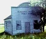 Piney, MB old municipal office, 1979
See also
References
- "Piney, Manitoba". Canadian Climate Normals 1971–2000 (in English and French). Environment Canada. Retrieved February 5, 2014.
External links
Places adjacent to Rural Municipality of Piney | |
|---|---|
Division No. 1, Manitoba (Eastern Manitoba) | ||
|---|---|---|
| Towns | 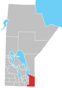 | |
| Local government districts | ||
| Rural municipalities | ||
| First Nations | ||
| Indian reserves |
| |
| Unorganized areas | ||
| Unincorporated communities | ||