Grand Rapids, Manitoba
Grand Rapids is a town in Manitoba, Canada located on the northwestern shore of Lake Winnipeg where the Saskatchewan River enters the lake. As the name implies, the river had a significant drop at this point (more than 75 ft (23 m) in less than 3 mi (4.8 km)). In modern days, a large hydro electric generating plant has been built. Cedar Lake, just a short distance up the river provides a natural water storage for this plant. Provincial Trunk Highway 6, the primary roadway in the region, crosses the Saskatchewan River at the Grand Rapids bridge.
Grand Rapids Misipawastik | |
|---|---|
Town | |
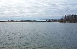 The Highway 6 bridge crosses the Saskatchewan River at Grand Rapids. | |
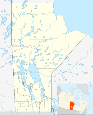 Grand Rapids Location of Grand Rapids in Manitoba | |
| Coordinates: 53°12′30″N 99°18′00″W | |
| Country | Canada |
| Province | Manitoba |
| Region | Northern Manitoba |
| Settled | 1877 |
| Area | |
| • Total | 85.95 km2 (33.19 sq mi) |
| Population (2016)[1] | |
| • Total | 268 |
| • Density | 3.1/km2 (8/sq mi) |
| • Change 2011-2016 | |
| • Summer (DST) | CST |
| Postal code | R0C 1E0 |
| Area code(s) | 204 |
Grand Rapids was on the main canoe route toward the west. Fort Bourbon stood here at one time. It also sits across the river from Misipawistik Cree Nation.
In 1894 fire destroyed a number of buildings in the Grand Rapids docks. The steamboat Colvile also caught fire and was destroyed.[2]
History
The first Fort Bourbon was built here in 1741 but was soon moved.[3] Grand Rapids was the only significant obstacle on the Saskatchewan-North Saskatchewan between the Rocky Mountains and Lake Winnipeg. Going downstream the rapids were usually run demi-chargé using the south channel. Upstream the boats were pulled by towlines. In the 1780s the Hudson's Bay Company (HBC) began to use York boats on the river. A log road was constructed so that these large boats could be hauled on rollers. Here in June 1819, in retaliation for the Battle of Seven Oaks HBC governor William Williams captured a number of North West Company men. The next year the Nor'Westers captured some HBC men at the same spot. See Pemmican War[3]
In the 1870s the railroad reached Lake Winnipeg and steamboats appeared on the lake and river. In 1877 a 3 mi (4.8 km) long narrow-gauge railway using horse-drawn tramcars was built around the rapids. The spread of railways made the tramway obsolete and the HBC closed it in 1909. It was used for tourist excursions for the next forty years.[3] By the 1980s remains were still visible and parts of the trail were still in use.

Demographics
In the 2011 Census, Grand Rapids had a population of 279 living in 109 of its 180 total private dwellings.[1]
Climate
Grand Rapids has a humid continental climate (Koppen: Dfb) with vast seasonal differences. Summers are warm with occasional heat waves, although moderated by its relatively high latitude and proximity to the lake areas of Manitoba, resulting in seasonal lag in spring. In winter any moderation is eliminated because of lake freezing and its vast distance to oceans. As a result, winters are cold to severely cold. January has colder than −18 °C (0 °F) daily means.
| Climate data for Grand Rapids (1981–2010 normals) | |||||||||||||
|---|---|---|---|---|---|---|---|---|---|---|---|---|---|
| Month | Jan | Feb | Mar | Apr | May | Jun | Jul | Aug | Sep | Oct | Nov | Dec | Year |
| Record high °C (°F) | 7.5 (45.5) |
9.0 (48.2) |
17.0 (62.6) |
28.0 (82.4) |
32.5 (90.5) |
36.5 (97.7) |
37.5 (99.5) |
35.0 (95.0) |
31.7 (89.1) |
25.0 (77.0) |
17.5 (63.5) |
7.8 (46.0) |
37.5 (99.5) |
| Average high °C (°F) | −13.5 (7.7) |
−9.9 (14.2) |
−2.8 (27.0) |
6.4 (43.5) |
13.9 (57.0) |
20.1 (68.2) |
23.8 (74.8) |
22.7 (72.9) |
15.8 (60.4) |
7.6 (45.7) |
−2.8 (27.0) |
−10.7 (12.7) |
5.9 (42.6) |
| Daily mean °C (°F) | −18.2 (−0.8) |
−15 (5) |
−8.3 (17.1) |
1.1 (34.0) |
8.3 (46.9) |
14.9 (58.8) |
18.8 (65.8) |
17.8 (64.0) |
11.3 (52.3) |
3.8 (38.8) |
−6.5 (20.3) |
−14.9 (5.2) |
1.1 (34.0) |
| Average low °C (°F) | −22.9 (−9.2) |
−20.0 (−4.0) |
−13.7 (7.3) |
−4.2 (24.4) |
2.7 (36.9) |
9.7 (49.5) |
13.8 (56.8) |
12.8 (55.0) |
6.8 (44.2) |
0.1 (32.2) |
−10.1 (13.8) |
−19.2 (−2.6) |
−3.7 (25.3) |
| Record low °C (°F) | −43.0 (−45.4) |
−41.1 (−42.0) |
−36.1 (−33.0) |
−26.1 (−15.0) |
−13.3 (8.1) |
−3.5 (25.7) |
2.0 (35.6) |
−1.0 (30.2) |
−9.0 (15.8) |
−16.0 (3.2) |
−32.5 (−26.5) |
−39.4 (−38.9) |
−43.0 (−45.4) |
| Average precipitation mm (inches) | 17.6 (0.69) |
13.2 (0.52) |
21.5 (0.85) |
26.1 (1.03) |
52.1 (2.05) |
76.9 (3.03) |
71.4 (2.81) |
66.1 (2.60) |
59.3 (2.33) |
38.3 (1.51) |
26.1 (1.03) |
22.4 (0.88) |
491.0 (19.33) |
| Average snowfall cm (inches) | 17.6 (6.9) |
13.0 (5.1) |
17.6 (6.9) |
12.0 (4.7) |
4.8 (1.9) |
0.0 (0.0) |
0.0 (0.0) |
0.0 (0.0) |
0.3 (0.1) |
8.3 (3.3) |
20.4 (8.0) |
22.4 (8.8) |
116.3 (45.8) |
| Source: Environment Canada[4] | |||||||||||||
References
- "Corrections and updates: Population and dwelling count amendments, 2011 Census". Statistics Canada. February 14, 2013. Retrieved February 16, 2013.
- Laberge, Jared (27 July 2005). "Navigating the Red: Steamships and the Colville Landing". St. Clements Heritage. Archived from the original on 23 February 2014.
- "Manitoba Historical Society (Thundering Waters Stilled: The Grand Rapids of the Saskatchewan by Martha McCarthy)". 1988. Retrieved 2014-02-19.
- "Canadian Climate Normals 1981–2010". Environment Canada. Retrieved 10 June 2018.
- Elizabeth Browne Losey, "Let Them be Remembered: The Story of the Fur Trade Forts",1999
External links
| Wikimedia Commons has media related to Grand Rapids, Manitoba. |
- Map of Grand Rapids at Statcan
- The Grand Rapids Tramway, An Abandoned Route of the Fur Trade
- Historic Sites of Manitoba: Grand Rapids Tramway (Grand Rapids, Northern Manitoba)
- The Grand Rapids Tramway: The First Railway in the Canadian Northwest
| Subdivisions |
| ||
|---|---|---|---|
| Cities | |||
| Towns |
| ||
| Villages |
| ||
| |||
| Cities |
|  |
|---|---|---|
| Towns | ||
| Rural municipalities | ||
| First Nations | ||
| Indian reserves | ||
| Unorganized areas | ||
| Unincorporated communities | ||