Rural Municipality of Springfield
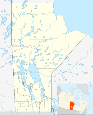
Springfield is a rural municipality (RM) in Manitoba, Canada. It stretches from urban industrial development on the eastern boundary of the City of Winnipeg, through urban, rural residential, agricultural and natural landscapes, to the Agassiz Provincial Forest on the municipality's eastern boundary. Birds Hill Provincial Park nestles into the northwestern corner of Springfield.
Springfield | |
|---|---|
Rural Municipality | |
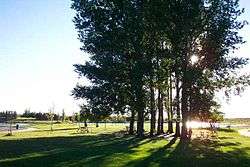 Birds Hill Provincial Park in northwestern Springfield | |
 Springfield | |
| Coordinates: 49°55′45″N 96°41′38″W | |
| Country | |
| Province | |
| Region | Winnipeg Metro Region |
| Government | |
| • Mayor | Tiffany Fell |
| Area | |
| • Rural Municipality | 1,100.92 km2 (425.07 sq mi) |
| • Metro | 5,306,79 km2 (204,896 sq mi) |
| Elevation | 242 m (794 ft) |
| Population (2016)[1] | |
| • Rural Municipality | 15,342 |
| • Density | 14/km2 (36/sq mi) |
| • Metro | 778,489 |
| Time zone | UTC−6 (CST) |
| • Summer (DST) | UTC−5 (CDT) |
| Postal Code | R5L, R5M, R5N, R5P, R5R, R5T |
| Area codes | 204, 431 |
| Website | www |
Information
Springfield was incorporated in 1880 as a result of changes made to the RM of Springfield and Sunnyside (1873–1880).[2] The municipality received its name due to the presence of multiple natural springs found within its borders.[2] While farming is still important in the municipality, today many residents are employed in nearby Winnipeg.
Springfield's population was 15,342 as of the 2016 census, making it the second most populous RM in the province (slightly behind the RM of Hanover) and fifth most populous municipality overall (behind the cities of Winnipeg, Brandon, and Steinbach, and RM of Hanover). [1]
Communities
- Anola
- Cooks Creek
- Dugald
- Hazelridge
- Oakbank
Historic sites
The RM of Springfield contains many sites of historical and cultural significance such as the Sunnyside cemetery, the Springfield Hutterite colony, North Springfield school, Springfield Agricultural Society and the Dugald rail accident site.[3] In 1996, the Ukrainian Catholic Church of the Immaculate Conception in Cooks Creek was designated a National Historic Site of Canada.[4]
Government
Municipal
The RM is governed by a reeve and councilors representing the RM's five wards. The government has come under some scrutiny for having the highest compensation to mayor and council ($242,974 total for 2015) relative to all other municipalities in the Winnipeg capital region.[5]
Springfield's administrative center is in Oakbank, the largest community in the RM.
Provincial
The RM is represented by two ridings in the Manitoba Legislative Assembly: Springfield-Ritchot (west) and Dawson Trail (east). The former Springfield electoral district included all of the RM and parts of adjacent East St. Paul.
Federal
The RM is split between two federal ridings: Selkirk—Interlake—Eastman (north) and Provencher (south). From 1914 through 1966, a federal riding was also called "Springfield" with varying boundaries not always coterminous with the municipality.[6]
References
- "2016 Census Profile - RM of Springfield". statcan.gc.ca. November 29, 2017. Retrieved December 25, 2019.
- "Manitoba Municipalities: Springfield". Manitoba Historical Society. Manitoba Historical Society. Retrieved 17 October 2015.
- "Search results for "Springfield"". Manitoba Historical Society. Manitoba Historical Society. Retrieved 17 October 2015.
- "Ukrainian Catholic Church of the Immaculate Conception National Historic Site of Canada". www.pc.gc.ca. Retrieved 2020-02-11.
- Bill Redekop (17 February 2015). "Salaries for municipal leaders in the capital region vary widely – Winnipeg Free Press". Winnipegfreepress.com. Retrieved October 29, 2015.
- "History of Federal Ridings Since 1867". parl.gc.ca. Archived from the original on October 23, 2012.
Further reading
- Aileen Kraushar et al., Springfield 1st Rural Municipality in Manitoba 1873-1973, Dugald Women's Institute, Dugald Manitoba Canada 1974, ISBN 0-919212-40-9
External links
| Wikimedia Commons has media related to Rural Municipality of Springfield. |
- R.M. of Springfield (official site)
- Community Profile: Springfield Rural Municipality, Manitoba; Statistics Canada
- Map of Springfield R.M. at Statcan
Places adjacent to Rural Municipality of Springfield | ||||||||||
|---|---|---|---|---|---|---|---|---|---|---|
| ||||||||||
| Towns | 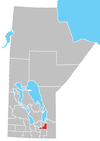 | |
|---|---|---|
| Rural municipalities | ||
| Unincorporated communities | ||