Rural Municipality of St. Clements
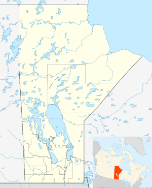
St. Clements is a rural municipality in Manitoba, Canada. It is located to the north-east of Winnipeg, stretching from East St. Paul and Birds Hill Provincial Park in the south to Lake Winnipeg and Grand Beach Provincial Park to the north. The Red River demarcates the western boundary of the municipality. St. Clements contains the communities of East Selkirk, and Lockport east of the Red River. It almost completely surrounds the Brokenhead 4 Indian reserve, with the exception of a small lakefront on Lake Winnipeg. Its population at the 2001 census was 9,115. The city of Selkirk borders it to the west, across the Red River of the North.
| Historical population | ||
|---|---|---|
| Year | Pop. | ±% |
| 1981 | 6,294 | — |
| 1986 | 6,922 | +10.0% |
| 1996 | 8,516 | +23.0% |
| 2001 | 9,115 | +7.0% |
| 2006 | 9,706 | +6.5% |
| 2011 | 10,505 | +8.2% |
St. Clements | |
|---|---|
Rural Municipality | |
 St. Clements | |
| Coordinates: 50°16′08″N 96°40′27″W | |
| Country | |
| Province | |
| Region | Winnipeg Metro Region |
| Government | |
| • Mayor | Debbie Fiebelkorn |
| Area | |
| • Rural Municipality | 730.11 km2 (281.90 sq mi) |
| • Metro | 5,306.79 km2 (2,048.96 sq mi) |
| Elevation | 227 m (745 ft) |
| Population (2016)[1] | |
| • Rural Municipality | 10,876 |
| • Density | 15/km2 (39/sq mi) |
| • Metro | 778,489 |
| Time zone | UTC−6 (CST) |
| • Summer (DST) | UTC−5 (CDT) |
| Area codes | 204, 431 |
Communities
- Beaconia
- East Selkirk
- Grand Marais
- Libau
- Lockport (part)
- Scanterbury
- Thalberg
References
- "2016 Census Profile - RM of St. Clements". statcan.gc.ca. Statistics Canada. November 29, 2017. Retrieved December 25, 2019.
External links
- Rural Municipality of St. Clements website
- Red River North Heritage Discover the rich heritage of one of the oldest settled areas of Manitoba, Canada.
- Map of St. Clements R.M. at Statcan
Places adjacent to Rural Municipality of St. Clements | |
|---|---|
| Cities | 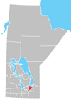 | |
|---|---|---|
| Villages | ||
| Rural municipalities | ||
| First Nations | ||
| Indian reserves | ||
| Unincorporated communities | ||
This article is issued from Wikipedia. The text is licensed under Creative Commons - Attribution - Sharealike. Additional terms may apply for the media files.