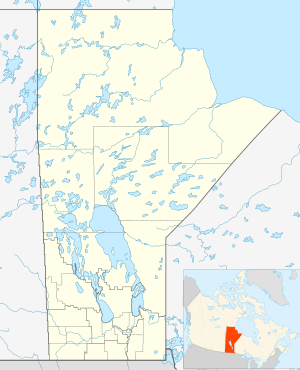
Rural Municipality of Macdonald
For the community of the same name, see: Macdonald, Manitoba
Rural Municipality of Macdonald | |
|---|---|
Rural Municipality | |
 Rural Municipality of Macdonald | |
| Coordinates: 49°40′21″N 97°26′50″W | |
| Country | |
| Province | |
| Government | |
| • Reeve | Brad Erb |
| Area | |
| • Total | 1,158.33 km2 (447.23 sq mi) |
| Elevation | 232 m (761 ft) |
| Population (2016) | |
| • Total | 7,162 |
| • Density | 6.2/km2 (16/sq mi) |
| Time zone | UTC−6 (CST) |
| • Summer (DST) | UTC−5 (CDT) |
| Area codes | 204, 431 |
| Website | www |
Macdonald is a rural municipality lying adjacent to the southwest side of Winnipeg, Manitoba, Canada. It is part of the Winnipeg Metro Region, but is not part of the smaller Winnipeg census metropolitan area. Macdonald's population as of the 2016 census was 7,162.
The municipality is named for Canada's first Prime Minister, Sir John A. Macdonald.
Water
Water services are sourced from the La Salle River[1] and is treated by a Water Treatment Plant located in Sanford. In 2016 an application to the Manitoba Water Services Board to expand the raw water storage facility by adding a fourth pond with a 90 dam3 capacity was made. Included in the project was a new aeration system for all four ponds.[1]
References
- "Macdonald Upgrades Notice of Alteration for the Manitoba Water Srevices Board & the RM Macdonald Water Treatment Plant" (PDF). gov.mb.ca. June 22, 2016. Retrieved February 13, 2020.
External links
- Official website
- Community Profile: Macdonald Rural Municipality, Manitoba; Statistics Canada
- Map of Macdonald R.M. at Statcan
Places adjacent to Rural Municipality of Macdonald | |
|---|---|
Division No. 10, Manitoba (Whitehorse Plains) | ||
|---|---|---|
| Rural municipalities | 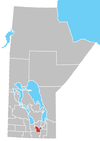 | |
| Unincorporated communities | ||