Roads in India
Roads are an important mode of transport in India. India has a network of over 5,897,671 kilometres (3,664,643 mi) of roads as of 31 March 2017. This is the second-largest road network in the world, after the United States with 6,645,709 kilometres (4,129,452 mi).[2] At 1.80 kilometres (1.12 mi) of roads per square kilometre of land, the quantitative density of India's road network is equal to that of Germany, and substantially higher than the United States (0.68 km, 0.42 mi), China (0.49 km, 0.30 mi), Brazil (0.18 km, 0.11 mi) and Russia (0.09 km, 0.056 mi).[2] Adjusted for its large population, India has approximately 4.87 kilometres (3.03 mi) of roads per 1,000 people.[3] As of 31 March 2017, 63.24% of Indian roads were paved.[2] India's road network carries over 65 percent of its freight and about 85 percent of passenger traffic.[4] It contributed 4.7 percent towards India's gross domestic product. This is in comparison to railways, which contributed 1 percent from 2009 to 2010.[5]
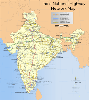
Since the 1990s, major efforts have been underway to modernize the country's road infrastructure.[3][6] The length of national highways in India has increased from 70,934 km (44,076 mi) in 2010–11 to 142,126 km (88,313 mi) in 2018–19.[2] As of May 2017, India had completed and placed into use over 28,900 kilometres (18,000 mi) of four- or more-lane highways connecting many of its major manufacturing, commercial and cultural centres.[7] According to Ministry of Road Transport and Highways, as of March 2019, India had about 142,126 kilometres (88,313 mi) of national highways and expressways, plus another 176,166 kilometres (109,464 mi) of state highways.[2] Major projects are being implemented under the National Highways Development Project, a government initiative. Private builders and highway operators are also implementing major projects.[8][9]
According to 2009 estimates by Goldman Sachs, India will need to invest US$1.7 trillion on infrastructure projects before 2020 to meet its economic needs, a part of which would be in upgrading India's road network.[10] The investment in national highways increased from ₹14,095.87 crore (US$2.0 billion) in 2005–06 to ₹98,988.06 crore (US$14 billion) in 2015–16.[2] During the same period the total investment in national highways was ₹476,589.37 crore (US$67 billion). The Government of India is attempting to promote foreign investment in road projects.[10][11][12] Foreign participation in construction of the Indian road network has attracted 45 international contractors and 40 design/engineering consultants, with Malaysia, South Korea, United Kingdom and United States being the countries with the most involvement.[13]
Organization
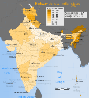
The Indian road network is administered by various government authorities, given India's federal form of government. The following table shows the total length of India's road network by type of road and administering authority as of 31 March 2016.[2]
| Category | Managing Authority | Length (km) | Length share |
|---|---|---|---|
| National highways | Ministry of Road Transport and Highways | 101,011[lower-alpha 1] | 1.80% |
| State highways | Public works department of state/union territory | 176,166 | 3.14% |
| Other PWD roads | Public works department of state/union territory | 561,940 | 10.03% |
| Rural roads | Panchayats and PMGSY | 3,935,337 | 70.23% |
| Urban roads | Municipal corporations and municipalities | 509,730 | 9.10% |
| Project roads | Various government departments of states/union territories, and SAIL, NMDC and BRO | 319,109 | 5.70% |
| Total | 5,603,293 | 100% |
Note
- This was increased to 131,326 km by December 2018, with the redesignation of about 39,040 km of state roads as National Highways.[14]
History
The first evidence of road development in the Indian subcontinent can be traced back to approximately around 2800 BC in the ancient cities of Harrapa and Mohenjodaro of the Indus Valley Civilization. Ruling emperors and monarchs of ancient and medieval India continued to construct roads to connect the cities. The existing Grand Trunk Road was re-built by the Mauryan Empire, and further rebuilt by subsequent entities such as the Sur Empire, the Mughal Empire and the British Empire.[15]
In the 1830s, the British East India Company started a programme of metalled road construction (a.k.a. gravel road), for both commercial and administrative purposes. The Grand Trunk Road – from Calcutta, through Delhi to Peshawar – was rebuilt at a cost of £1,000 per mile; roads from Bombay to Pune, Bombay to Agra and Bombay to Madras were constructed; and a Public Works Department and the Indian Institute of Technology Roorkee were founded, to train and employ local surveyors, engineers and overseers, to perform the work, and to maintain the roads. This programme resulted in an estimated 2,500 kilometres (1,600 mi) of metalled roads being constructed by the 1850s.[16][17]
In December 1934, the Indian Road Congress (IRC) was formed, on the recommendations of the Indian Road Development Committee (Jayakar Committee) of the Government of India. In 1943, they proposed a twenty-year plan to increase the road network from 350,000 kilometres (220,000 mi) to 532,700 kilometres (331,000 mi) by 1963, to achieve a road density of 16 km per 100 km2 of land. The construction was to be paid in part through the duty imposed, since 1939, on petrol sales. This became known as the Nagpur Plan. The construction target was achieved in the late 1950s.[18] In 1956, a Highways Act was passed, and a second twenty-year plan proposed for the period 1961–1981, with the ambition of doubling road density to 32 km per 100 km2. This second plan became known as the Bombay Road Plan.[18]
In 1988, an autonomous entity called the National Highways Authority of India (NHAI) was established by an Act of Parliament, and came into existence on 15 June 1989. The Act empowered NHAI to develop, maintain and manage India's road network through National Highways. However, little happened until India introduced widespread economic liberalization in the early 1990s. Since 1995, NHAI has increasingly privatized road network development in India.
In 1998, National Highways Development Project (NHDP) was started by the then Prime Minister Atal Bihari Vajpayee. The flagship project of the NHDP is the Golden Quadrilateral, a total of 5,846 kilometres (3,633 mi) of four-to-six-lane highways connecting the four major cities of Delhi, Mumbai, Chennai and Kolkata. The total cost of the project is ₹300 billion (US$4.2 billion), funded largely by the government's special petroleum product tax revenues and government borrowing. In January 2012, India announced that the four-lane GQ highway network was complete.[19][20]
Another important road project of the NHDP is the 7,142-kilometre (4,438 mi) four-to-six-lane North–South and East–West Corridor, comprising national highways connecting four extreme points of the country. The project aims to connect Srinagar in the north to Kanyakumari in the south (including a spur from Salem to Kanyakumari, via Coimbatore and Kochi), and Silchar in the east to Porbandar in the west. As of 31 October 2016, 90.99% of the project had been completed, 5.47% of the project work is under implementation and 3.52% of the total length is remaining.[21]
As of May 2017, under NHDP, about 28,915 kilometres (17,967 mi) of four-to-six-lane highways have been constructed (including the GQ and N–S/E–W Corridor), while a total of 48,793 kilometres (30,319 mi) of road has been planned to have four-to-six lanes under the NHDP.[22]
Bharatmala is a centrally-sponsored and funded road and highways project of the Government of India,[23] started in 2017, with a target of constructing 83,677 km (51,994 mi)[24] of new highways at an estimated cost of ₹5.35 trillion (US$75 billion). Bharatmala Phase I plans to construct 34,800 kilometres (21,600 mi) of highways (including the remaining projects that were under NHDP) by 2021–22, at an estimated cost of ₹535,000 crore (US$75 billion).[25]
India's rate of road building has accelerated since 2010s. It averaged about 12 kilometres (7.5 mi) per day in 2014–15 and 30 kilometres (19 mi) per day in 2018–19.[26] The country's target is to build 40 kilometres (25 mi) of highways per day.[27]
| Road Category | 1950–51 | 1960–61 | 1970–71 | 1980–81 | 1990–91 | 2000–01 | 2010–11 | 2015–16 |
|---|---|---|---|---|---|---|---|---|
| National Highways | 19,811 (4.95%) | 23,798 (4.54%) | 23,838 (2.61%) | 31,671 (2.13%) | 33,650 (1.45%) | 57,737 (1.71%) | 70,934 (1.52%) | 101,011 (1.80%) |
| State highways | ^ | ^ | 56,765 (6.20%) | 94,359 (6.35%) | 127,311 (5.47%) | 132,100 (3.92%) | 163,898 (3.50%) | 176,166 (3.14%) |
| District roads | 173,723 (43.44%) | 257,125 (49.02%) | 276,833 (30.26%) | 421,895 (28.40%) | 509,435 (21.89%) | 736,001 (21.82%) | 998,895 (21.36%) | 561,940 (10.03%) |
| Rural roads | 206,408 (51.61%) | 197,194 (37.60%) | 354,530 (38.75%) | 628,865 (42.34%) | 1,260,430 (54.16%) | 1,972,016 (58.46%) | 2,749,804 (58.80%) | 3,935,337 (70.23%) |
| Urban roads | 0 | 46,361 (8.84%) | 72,120 (7.88%) | 123,120 (8.29%) | 186,799 (8.03%) | 252,001 (7.47%) | 411,679 (8.80%) | 509,730 (9.10%) |
| Project roads | 0 | 0 | 130,893 (14.31%) | 185,511 (12.49%) | 209,737 (9.01%) | 223,665 (6.63%) | 281,628 (6.02%) | 319,109 (5.70%) |
| Total | 399,942 | 524,478 | 914,979 | 1,485,421 | 2,327,362 | 3,373,520 | 4,676,838 | 5,603,293 |
| Figures in parenthesis indicate percentage of total road length for that fiscal year. | ||||||||
Roads
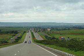
Expressways
.jpg)

Expressways are high-speed roads that are four- or more lanes, and are access controlled where entrance and exit is controlled by the use of ramps that are incorporated into the design of the expressway. Most of the existing expressways in India are toll roads.[28] Expressways make up approximately 1,583 km (984 mi) of India's road network, as of 2013.[29][28] The government has drawn up a target to build a 18,637-kilometre (11,580 mi) network of new expressways by 2022.[30]
National Expressways Authority of India (NEAI) operating under the Ministry of Road Transport and Highways will be in-charge of the construction and maintenance of expressways.[31] The National Highways Development Project by Government of India aims to expand the expressway network and plans to add an additional 18,637 km (11,580 mi) of expressways by 2022 apart from existing national highways.[32]
India's first expressway, the Delhi Noida Direct Flyway (DND Flyway), operational in 2001, is an expressway connecting Delhi and Noida in the states of Delhi and Uttar Pradesh. The Mumbai Pune Expressway, connecting Mumbai and Pune in Maharashtra fully operational in 2002, is India's first six-lane concrete high-speed access-controlled tolled expressway.[33][34] The Yamuna Expressway is a 165 km (103 mi) six-lane controlled-access expressway opened on 9 August 2012.[35] On 21 November 2016, the 302 km (188 mi) six-lane Agra Lucknow Expressway was opened.[36][37] Under construction as of 2019, the Mumbai–Nagpur Expressway is expected to become the largest expressway in the country. Several expressway projects, such as the Ganga Expressway, have been delayed for three or more years, due to litigation and bureaucratic procedures.
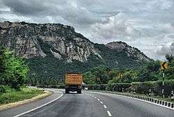
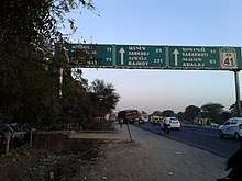
National highways
_at_Visakhapatnam.jpg)
National highways are highways connecting major cities through-out the country and are at-grade roads. National Highways are designated with NH, followed by the highway number. Indian national highways are further classified based on the width of the carriageway of the highway. India has 142,126 km (88,313 mi) of National Highways as of April 2019.[38] National Highways constituted 2.7% of India's total road network, but carried about 40% of road traffic, as of 2013.[39] In 2016, the government vowed to double the highway length from 96,000 to 2,00,000 km.[40]
The National Highways Authority of India (NHAI) is the authority responsible for the development, maintenance and management of the National Highways entrusted to it. The NHAI has been undertaking developmental activities under the National Highways Development Project (NHDP) in five phases. From 2018, the pending projects under NHDP are expected to be subsumed under Bharatmala. The NHAI is also responsible for implementing other projects on National Highways, primarily road connectivity to major ports in India.
The Golden Quadrilateral and North–South and East–West Corridor were major ongoing highway development projects in India.
| Lanes | Length (km) | Length share |
|---|---|---|
| Single-lane/intermediate lane | 20,703 | 20.49% |
| Double-lane | 55,603 | 55.05% |
| Four-lane/six-lane/eight-lane | 24,705 | 24.46% |
| Total | 101,011 | 100% |
State highways
State highways are highways connecting major cities through-out a state and are also at-grade roads. They also connect with National Highways or state highways of neighboring states. State Highways are designated with SH, followed by the highway number and preceded by state code. As of 31 March 2016, the total length of state highways was 176,166 kilometres (109,464 mi).[41] As of 31 March 2016, Maharashtra has the largest share of state highways among all states (22.14%), followed by Karnataka (11.11%), Gujarat (9.76%), Rajasthan (8.62%) and Tamil Nadu (6.67%).[2]
State governments have the authority and responsibility to build state highways. Most of the state highways are developed by state public works departments. Independently of the NHDP program, state governments have been implementing a number of state highway projects since 2000. By 2010, state highway projects worth US$1.7 billion had been completed, and projects worth an additional US$11.4 billion were under implementation.[42]
District roads

These are major roads within a district, connecting Taluka headquarters and major rural areas to district headquarters. They also connect with the state highways and national highways. District roads are sub-classified into "Major District Roads" (MDRs) and "Other District Roads" (ODRs). As per the broad classification of roads, the MDRs are to have a minimum width of 15 metres (49 ft) with traffic density of 5,000 to 10,000 Passenger car equivalents (PCUs). As on 31 March 2016, the total length of district roads in India was approximately 561,940 kilometres (349,170 mi), of which 94.93% of the total length was surfaced.[2]
The Zila Parishads have the authority and responsibility to build district roads.
Rural roads

Rural roads form a substantial portion of the country's road network, forming 70.23 percent of the total of roads, as of March 2016. As of the same date, the percentage of unsurfaced rural roads to the total rural road length was 66.15% (excluding 900,000 kilometres [560,000 mi] of rural roads built under the Jawahar Rozgar Yojana infrastructure program).[2]
For the development of these rural roads, Pradhan Mantri Gram Sadak Yojana (Prime Minister's Rural Roads Scheme) was launched in December 2000 by the Indian government to provide connectivity to isolated rural habitations. The scheme envisions that these roads will be constructed and maintained by the village panchayats. In some parts of India, the government has attempted to manage the programme directly as a local social spending program.[43]
In other parts of India, the Pradhan Mantri Gram Sadak Yojana and a sister program named Bharat Nirman (Build India) have privatized the rural road construction projects and deployed contractors. The effort has aimed to build all-season single-lane asphalted roads to connect India's rural and remote areas. A significant portion of funding for these projects has come from the World Bank and the Asian Development Bank.[44]
| Length 2001 | Length 2011 | Length under construction 2011 | |
|---|---|---|---|
| Total rural roads | 2.7 million | 3.1 million | 0.1 million |
| Paved unmaintained rural roads | 0.5 million | ||
| Unpaved rural roads | 2.2 million | 1.9 million | |
| Paved maintained rural roads | 728,871 | 53,634 | |
| New rural roads | 322,900 | 82,743 |
Issues
The main roads in India are under huge pressure and in great need of modernization in order to handle the increased requirements of the Indian economy. In addition to maintenance, the expansion of the network and widening of existing roads is becoming increasingly important. This would then enable the roads to handle increased traffic and also allow for a corresponding increase in the average movement speed on India's roads.
Congestion
In 2009, lane capacity was low, and only about 16% of India's roads were of four lanes or more.[11] A 2007 study found that congestion on India's highways reduced average truck and bus speeds to 30–40 km/h (19–25 mph); road maintenance was under-funded, and some 40 percent of villages in India lacked access to all-weather roads.[3] While the PMGSY rural road program has, by 2011, connected 90 percent of villages identified in 2005 as being without access,[45] many remote villages in India were still without access to a single-lane paved road as of May 2011.
India's intra-city vehicle speed is among the lowest in the world. As per a study by Ola Cabs, in 2017, the average traffic speed in Bengaluru was 17.2 km/h (10.7 mph), while Delhi had the highest traffic speeds in India at 25 km/h (16 mph).[46] Amongst other major cities, the average traffic speed in Mumbai was 20.7 km/h (12.9 mph); in Kolkata, 19.2 km/h (11.9 mph); in Hyderabad, 18.5 km/h (11.5 mph); and in Chennai, 18.9 km/h (11.7 mph).[46]
The low road densities per thousand people have created significant congestion, and slow speeds on existing roads within cities. Because of the congestion, the fuel efficiency of vehicles in India is very low. This increases the overall fuel consumption per kilometre-equivalent travelled, resulting in heavy pollution due to engine inefficiently at low speeds.[47] Pollutants from the poor road network and from resultant poor fuel efficiencies include hydrocarbons, NO
x , SO
2, methane, carbon monoxide and carbon dioxide – all of which cause health problems, adverse climate effects and related environmental damage.
Due to rising petroleum prices, and with this being a non-renewable resource, some have urged the Indian government to focus instead on improving public transport including the Indian Railways and rapid transit systems.[48] Many cities have proposed, or are implementing, metros and mass transit systems.
Construction issues
In a 2011 report, The Economist noted that the rural road scheme, and the Mahatma Gandhi National Rural Employment Guarantee, were India's biggest single welfare project, costing over $8 billion a year, and accounting for 3% of all public spending in India. The report claims that Jairam Ramesh, the minister in charge of the central government department administering the program, criticizes the patchy implementation of the scheme, describing wasteful poor construction and funds being diverted to corrupt officials; reports suggest that up to two-thirds of funds allocated to the scheme are lost. A Ministry review, carried out in September 2011, found a lack of skilled technicians on construction sites. Rules against machinery and contractors are also claimed to be in force, requiring unskilled manual labour to maximize employment, resulting in roads that are destroyed each monsoon season and must be rebuilt annually.[49]
Fatalities
The World Health Organization's compilation of road network safety data for major economies found India to have the highest number of road fatalities in the world, with 105,000 deaths caused by road accidents in 2006.[50] However, adjusted for India's larger population, the accident and fatality rates are similar to those major economies. Over 2004–2007, India had a road fatality rate of 137 deaths per million citizens, compared to 133 deaths per million citizens in the United States. There were 429 non-fatal accidents reported per million citizens on Indian roads, compared to 412 such accidents per million citizens in China, and 1,101 in the United States. The report notes that not all accidents in India and China are reported and recorded.
In the three years between 2015 and 2017, potholes in India were a factor in over 9,300 deaths, according to government figures.[51][52] In 2017, 3,579 people were killed and 25,000 injured due to pothole-related mishaps.[53]
Efforts to address issues
India's later efforts to build modern highways and improve its road network have made a significant difference to trucking logistics. According to global logistics company DHL, the average time to truck shipments from New Delhi to Bengaluru, a journey of over 2,000 kilometres (1,200 mi), had dropped in 2008 to about five days.[54] By 2010, the average time to complete a road trip from New Delhi to Mumbai, over 1,400 kilometres (870 mi), had dropped to about 35 hours. In contrast, a similar journey takes about half the time in China, and one-third in European Union countries. In a 2010 report, auditing company KPMG noted marked improvements in the Indian road network and in the country's logistics efficiency in recent years.[55] The report also identified the competitive challenges faced by India. Some findings of this report include:
- The average road speed in India has increased to 30–40 kilometres per hour (19–25 mph). The worldwide average road speed (including China) is around 60–80 kilometres per hour (37–50 mph).
- The four-lane road network in India has increased to 7,000 kilometres (4,300 mi).
- Average surface freight costs have dropped to US$0.07 per kilometre. Japan, in comparison, has average surface freight costs of US$0.037 per kilometre.
The KPMG report also notes that logistics and transportation bottlenecks in India's road network hinder its GDP growth by one to two percent (US$16–32 billion).[55] Considering India's 2010 per capita income, this is equivalent to a loss of about 10 million new jobs every year. Poor rural roads and traffic congestion inside the cities remains a challenge in India. The planned addition of over 12,000 kilometres (7,500 mi) of expressways in the next 10 years may help address some of these issues.
See also
- Transport in India
- List of National Highways in India by highway number
- List of National Highways in India by old highway number
- Expressways in India
- Impact of roads on the Sustainable Development Goals(SDGs) in India[56]
References
- Table - Distribution of density of road network, Ministry of Roads Transport and Highways, Government of India (2013)
- "Basic Road Statistics of India 2016-17" (PDF). Ministry of Road Transport and Highways. Retrieved 22 March 2020.
- "India Transport Sector". World Bank.
- "An Overview: Road Network of India". Ministry of Road Transport, Government of India. 2010.
- "Report of Working Group on Road Transport" (PDF). Ministry of Road Transport, Government of India. 2011.
- "India en route for grand highways". BBC News.
- "National Highway Development Project NHDP)". NHAI, Ministry of Roads Transport, Govt of India. March 2017. Archived from the original on 15 May 2016. Retrieved 31 March 2017.
- Yamuna Expressway to open in April, trial runs on The Times of India
- Gadkari to open 53-km stretch of Kundli-Manesar-Palwal expressway today hindustantimes (Apr 05, 2016)
- Shobana Chandra. "U.S. Pension Funds May Invest in India Road Projects, Nath Says". Bloomberg L.P.
- RN Bhaskar. "Crossing the Chasm". Forbes India.
- Suman Guha Mozumder. "Kamal Nath on what dogs Indian road projects". Rediff.
- Indian Highways - Emerging Opportunities Archived 14 July 2014 at the Wayback Machine Govt of India, Page 15
- Length of National Highways in The Country, Ministry of Road Transport & Highways, 27 December 2018.
- Taylor (1995). A Star Shall Fall. Collins. ISBN 978-81-7223-066-1.
- St. John, Ian (2011). The Making of the Raj: India under the East India Company. ABC-CLIO. pp. 83–84. ISBN 9780313097362. Retrieved 15 May 2018.
- Gupta, Das (2011). Science and Modern India: An Institutional History, c.1784-1947: Project of History of Science, Philosophy and Culture in Indian Civilization, Volume XV, Part 4. Pearson Education India. pp. 454–456. ISBN 9788131753750.
- Jagarlamudi, Vishnu. "History of Road Development in India". Scribd. Retrieved 5 May 2018.
- "Govt declares Golden Quadrilateral complete". The Indian Express. 7 January 2012.
- "National Highways Development Project Map". National Highways Institute of India. Archived from the original on 4 March 2016. Retrieved 16 January 2018.
- "About NHDP". NHAI. Retrieved 16 January 2018.
- "Bharat Mala: PM Narendra Modi's planned Rs 14,000 crore road from Gujarat to Mizoram", The Economic Times, New Delhi, 29 April 2015
- "Ministry proposes construction of 20,000 km of roads under Bharat Mala project", The Economic Times, New Delhi, 9 January 2016
- "Bharatmala Pariyojana - A Stepping Stone towards New India | National Portal of India". www.india.gov.in. Retrieved 18 January 2018.
- "Highway construction grew 20 pct in 2017-18". The Financial Express. 4 April 2018. Retrieved 11 April 2018.
- "Budget 2018: Allocation for highways set to treble in Modi's term - Times of India". The Times of India. Retrieved 15 January 2018.
- "Check out India's 13 super expressways". Rediff. July 2011.
- "India Roads – November 2010" (PDF). IBEF. November 2010.
- "Project Report on Indian National Expressway Network". Ministry of Road Transport and Highways, Government of India. October 2011.
- Dash, Dipak Kumar (23 November 2009). "By 2022, govt to lay 18,637km of expressways". Times of India.
- Kumar, Ashutosh. "Expressway cost pegged at Rs20 crore/km". Daily News and Analysis. Retrieved 16 September 2016.
- "Mumbai-Pune Expressway, India". Road Traffic Technology. Retrieved 21 August 2010.
- "Rs 7,000-cr project to add more lanes to expressway, NH-4". Indian express. Express News Agency. 6 February 2015. Retrieved 21 November 2015.
- "Yamuna Expressway from Delhi to Agra opens: 10 facts".
- "Eight fighter jets to land on Agra-Lucknow expressway". Business Insider.
- "6 Jets Touch Down For Opening Of Agra-Lucknow Expressway, India's Longest". NDTV.com.
- "Ministry of Road Transport and Highways". Retrieved 25 October 2017.
- Mahapatra, Dhananjay (2 July 2013). "NDA regime constructed 50% of national highways laid in last 30 years: Centre". The Times of India. Retrieved 18 April 2015.
- "National Highways road length to be increased from 96,000 km to 2,000,000 km: Nitin Gadkari". The Financial Express. 17 December 2016. Retrieved 27 June 2017.
- Basic Road Statistics of India 2014 (Report). Ministry of Road Transport & Highways. 23 May 2014. Retrieved 21 June 2014.
- "Compendium of PPP Projects in State Highways" (PDF). Secretariat for Infrastructure, Govt of India. June 2010. Archived from the original (PDF) on 25 April 2012.
- "India's boom bypasses the poor". The Wall Street Journal. 29 April 2011.
- "New all weather roads boost rural incomes, India". The World Bank. 2009.
- "Pradhan Mantri Gram Sadak Yojana (PMGSY) including Bharat Nirman (Rural Connectivity) Program Review". Ministry of Rural Development, Government of India. July 2011.
- "Surprise Surprise, Bengaluru traffic speed slowest says study by Ola". The News Minute. 30 December 2017. Retrieved 11 April 2018.
- John Pucher; Nisha Korattyswaropam; Neha Mittal; Neenu Ittyerah. "Urban transport crisis in India" (PDF). Archived from the original (PDF) on 14 March 2007.
- "Kamal Nath on India's Infrastructure" – via www.youtube.com.
- "Indian rural welfare: Digging holes". The Economist. 5 November 2011.
- "Global Status Report on Road Safety" (PDF). World Health Organization. 2009.
- K. Dash, Dipak (15 July 2018). "Potholes: Potholes killed 3,597 across India in 2017, terror 803". The Times of India. Retrieved 16 July 2019.
- Kaur, Kamaljit (24 July 2018). "Over 9300 deaths, 25000 injured in 3 years due to potholes". India Today. Retrieved 16 July 2019.
- Dhillon, Amrit (24 July 2018). "'More deadly than terrorism': potholes responsible for killing 10 people a day in India". The Guardian. ISSN 0261-3077. Retrieved 16 July 2019.
- "Logistics in India". DHL. 2008. Archived from the original on 24 July 2012.
- "Logistics in India, part 1 (A 3 part series)" (PDF). KPMG. 2010.
- https://www.teriin.org/sites/default/files/2019-05/rural-roads-sdgs.pdf
External links
| Wikimedia Commons has media related to Roads in India. |
