Hierarchy of roads
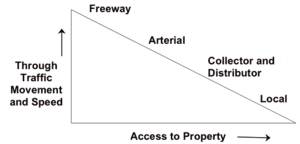
The hierarchy of roads categorizes roads according to their functions and capacities. While sources differ on the exact nomenclature, the basic hierarchy comprises freeways, arterials, collectors, and local roads. Generally, the functional hierarchy can more or less correspond to the hierarchy of roads by their owner or administrator.
The related concept of access management aims to provide access to land development, while ensuring traffic flows freely and safely on surrounding roads.
United States and Canada
| VMT Rural | VMT Urban |
|---|---|
 |
 |
| Source RITA DOT[1] | |
- Bureau of Transportation Statistics (n.d.). "Table 2-18: Motor Vehicle Fatalities, Vehicle-Miles, and Associated Rates by Highway Functional System". National Transportation Statistics. United States Department of Transportation. Retrieved August 10, 2017.
Freeways
At the top of the hierarchy are limited access roads Freeways or Expressways, including most toll roads. These roads provide largely uninterrupted travel, often using partial or full access control, and are designed for high speeds. Some freeways have collector/distributor lanes (also known as local lanes) which further reduce the number of access ramps that directly interface with the freeway; rather, the freeway periodically interfaces with these parallel roadways, which themselves have multiple on and off-ramps. These allow the freeway to operate with less friction at an even higher speed and with higher flow. Often freeways are included in the next category, arterials.
Arterials
Arterials are major through roads that are expected to carry large volumes of traffic. Arterials are often divided into major and minor arterials, and rural and urban arterials.
In some places there are large divided roads with few or no driveways that cannot be called freeways because they have occasional at-grade intersections with traffic lights that stop traffic (expressways in California, dual carriageways in Britain) or they are just too short (superarterials in Nevada). Such roads are usually classified as arterials.
Frontage roads are often used to reduce the conflict between the high-speed nature of an arterial and property access concerns.
Collectors
Collectors (not to be confused with collector lanes, which reduce weaving on freeways), collect traffic from local roads, and distribute it to arterials. Traffic using a collector is usually going to or coming from somewhere nearby.
Local roads
At the bottom of the hierarchy are local streets and roads. These roads have the lowest speed limit, and carry low volumes of traffic. In some areas, these roads may be unpaved.
Europe
Most of Europe Has a legal system based on European and international treaties which define at European/international level three types of road: motorways, express roads, and other roads. This vision comes from the 20th century and is limited to traffic code and legal issues. Each nation has its own Hierarchy of roads, although there is also a European road numbering at European level, for European roads.
Most of Europe has adopted Motorways (Autoroutes/Autobahnen/Autopistas/Autostrade), usually similar to those in France and the UK. The idea was originally developed in Germany, where all motorways are toll-free, and has spread widely. All major through routes in the EU and neighbouring countries have a European E-Road number in addition, or in the case of some countries' motorways, instead of a national number. In the UK these numbers are not displayed.
Otherwise, most other European countries have some form of differentiating between national routes, regional and inter-regional roads and other local routes.
United Kingdom
Motorway
Motorways, similar to freeways, these high-speed roads are designated with an M prefix or (M) suffix. e.g. M1, A1(M). The speed limit is generally 70 miles per hour (110 km/h) and there is a hard shoulder, an often slightly narrower lane next to lane 1, which is usually only to be used in cases of an emergency. Emergency telephones are located every mile along the route so motorists with broken-down vehicles can contact the authorities, although this is increasingly being done using mobile phones. Signs are blue with white text for both destinations and motorway numbers. In general, junctions are given numbers which are displayed prominently, sometimes with a letter suffix, in a small black box on all the signs for any given junction. Junctions are generally signed one mile before they exit, with three or four further signs as the junction is reached, although on busy urban stretches this first warning can reduce to about ⅓mile. Cyclists, pedestrians, mopeds, very slow vehicles and certain other traffic are banned.
Primary A-road
Green on maps and signs. A main recommended route these can be single track as in North West Sutherland or more usually single carriageway or dual carriageway. The primary road network is fully connected, meaning you can reach any part from any other without leaving the network. Some of the major dual carriageway primary routes have numbered junctions or hard shoulders in the style of the Continental semi-motorways. Many Primary Routes are largely or wholly subject to clearway restrictions, and in major cities they may be classed as red routes. Emergency telephones, if present at all, are usually infrequent - there may be some additional telephones operated by the UK's two main motoring organisations, the RAC and the AA, but these are becoming rarer.
Non-primary A-road
Often exists where the route is important but there is a nearby primary route (A or motorway) which duplicates this road's function. Shown as red on maps, and has white signage with black lettering. Some non-Primary A-class roads are partially subject to clearway restrictions.
B road
Regional in nature and used to connect areas of lesser importance. Usually shown as brown or yellow on maps and have the same white signs as non-Primary A-Class routes. If the route is primary, like the B6261, then it will be shown the same as a Primary A-Class route.
C road
C roads are used as local authority designations for routes within their area for administrative purposes. These routes are not shown on road maps, but have occasionally been known to appear on road signs.
Unclassified
Unclassified roads are local roads with no defined destination. Local destinations may, however, be signed along them.
France
In France, one hierarchy of road is based on the owner who manages the road. Independently of that, roads can have various specificities such as speed or crossings.
Autoroutes
Along with the rest of Europe, France has Motorways or Autoroutes similar to the British network. Unlike in the UK, the network is mostly accessible on payment of a toll, which is usually distance-dependent; there are generally more Toll (péage) Motorways in the South of France. However, sections passing through or close to major towns and cities are usually free. As in the UK, destinations reached via a motorway are shown with white text on a blue background. Junctions are usually numbered, the numbers being shown on signs in a small oval in the corner of the sign.
Route Nationale
Before the construction of Autoroutes, the Routes Nationales were the highest classification of road. They are denoted by a route number beginning N, or occasionally, RN. Going back to a Napoleonic road classification system, these are main roads comparable with British Primary Routes. They are maintained directly by the state and are usually the shortest route between major centres. Many N-Class roads are dual carriageway for some or all of their length, with a few also being given the designation of semi-motorway, where junctions are grade-separated and there is a central reservation with crash barrier. The hard shoulder, or bande d'arrêt d'urgence, is often narrower than on full motorways and there are fewer emergency telephones.
Routes Départementales
France (including overseas territory) is split into 100 departments, the second-highest tier of local government, similar to a UK county or US state. The departments have responsibility for all roads beginning with a letter D, or occasionally RD. These roads vary in quality, from newly built local dual carriageways and downgraded Routes Nationales to winding roads that are barely wide enough for traffic to pass. Generally, they are quieter than the Routes Nationales, and of a reasonable standard.
Routes Communales
In general, each settlement in France is a Commune - akin to a British Civil Parish. This most local level of government is responsible for maintaining all the local roads, which are numbered with a letter C prefix. Except in major towns and cities, where their numbers are usually not marked on signs, they are usually single-track and may be in a state of poor repair due to the large number of roads covered by populations as small as 10.
Hungary
Hungarian road categories are as follows:
- Gyorsforgalmi út (controlled-access highway):
- Autópálya (motorway): at least 2+2 travel lanes and 1+1 emergency lane, central reservation, no at-grade intersections, speed limit: 130 km/h
- Autóút (expressway): 1+1 or more travel lanes, optionally emergency lanes and central reservation, some at-grade intersections(only if 1+1 lanes), speed limit: 110 km/h
- Főút (arterial road or main road) (with one digit in their name, e.g.: 6-os út)
- Megyei út (county road) (with two digits, e.g.: 16-os út)
- Helyi út (local road) (with three or more digits)
etc.
Czech Republic and Slovakia
The current categorization in the Czech Republic and Slovakia originates from the Czechoslovak 1961 road act.
- Dálnice (freeways, commonly translated as highways) – numbered by 1-digit or 2-digit numbers, distinguished by red color of the number plates or by the letter D (D0, D11 etc.). Dálnice are owned by the state (by the republic).
- Silnice (roads)
- 1st class roads – they are numbered by 1-digit or 2-digit numbers, distinguished by blue color of the number plates or by the Roman numeral of the class before the number (I/4, I/101). Some of first-class roads or their sections are signed as expressways (motorways) and have similar traffic rules as freeways. 1st class roads are owned by the state (by the republic) and traditionally called "state roads".
- 2nd class roads are numbered by 3-digit numbers and signed by blue color of the number plates, possibly supplemented by the Roman numeral of the class before the number (II/101, II/613). 2nd class roads are owned by self-governing regions and traditionally called "regional roads". In Slovak cities of Bratislava and Košice, the sections are owned and managed by the cities. In the Czech capital of Prague, only several marginal sections are classified as 2nd class roads.
- 3rd class roads are numbered by 4-digit or 5-digit numbers in the Czech Republic. Slovakia used 5-digit or 6-digit numbers until 1st May 2015 when it was replaced by new 4-digit numbering. The old Czechoslovak numbers of 3-class roads are derived from the number of closest road of higher class. The new Slovak numbering express belonging to a district. In the Czech Republic, 3rd class roads (traditionally called "district roads) are owned by regions, as the district administration was cancelled since 2003. The City of Prague (which has the status of region as well as municipality) has no 3rd class roads. In Slovakia, 3rd class roads are owned by self-governing regions (excluding the cities of Bratislava and Košice). In the Czech Republic,the numbers of 3rd class roads are not marked on signs nor in common maps. They are available on special maps only, and are used for administrative and maintenance purposes only.
- Místní komunikace (local communications) are owned and managed by municipalities (all towns and cities have also status of municipalities). According to the Road Act and its implementing regulations, they should be numbered by local numbering, but such a numbering is not available to the public and really not required by the state. In reality, only street names are used for identification. Technically, local communications are distinguished to 4 classes similar to classes of roads (the 4st class are pedestrian or cyclist zones or paths), but the classification is used only in very specialized administration maps. statutory cities can delegate administration of low-class streets or administration of sidewalks to self-governing boroughs.
- Účelová komunikace (utilitarian communication) can be owned by any subject, private as well as public. Such communications are often subject of litigations because the legal status is a bit inconsistent and unclear.
- veřejně přístupná (open to the public) has similar traffic mode as municipal communications; generally, forest roads and field roads are count among "utilitarian/purpose communications". However, motor vehicles are prohibited at the forest roads by the Forest Act. The national law doesn't concern over compensations or subventions to the owner, and the duty of maintenance is questionable and not stated explicitly by the law.
- uzavřená (closed) is a communication in enclosed object or facility; outside of them, the owner needs an administrative decision to exclude or restrict the public traffic. Traffic rules applies to such communications, but the owner can permit exceptions.
Until 1938, separate lands of Czechoslovakia have different laws and road systems, inherited from the Austro-Hungarian period. Just in 1938, a unified Czechoslovak road act passed. In 1935, there existed Czechoslovak state roads (not distinguished by class) and several types of non-state public roads:
- in Bohemia, silnice zemské (land roads), silnice okresní (district roads), silnice a cesty obecní (municipal roads and ways) (there was only one remained 23km land road in Bohemia, connecting Jilemnice, Vysoké nad Jizerou and Rokytnice nad Jizerou)
- in Moravia, silnice okresní (district roads) of 1st and 2nd class, silnice a cesty obecní (municipal roads and ways)
- in Czech Silesia, silnice okresní (district roads) of 1st and 2nd class, silnice a cesty obecní (municipal roads and ways) and veřejné cesty interesentů (public ways of interesents)
- in Slovakia and Zakarpattia, zemské cesty (land roads, formerly župné cesty, župa roads), príjezdné cesty (access roads), vicinální cesty (vicinal roads), cesty obecné (municipal roads and ways) and cesty interesentů (ways of interesents).
Thus, in the Moravian-Silesian Land existed no land roads, in Slovakia and Zakarpattia were no district roads but existed a special class of "access roads", and in Bohemian and Moravia existed not a status of "public ways of interesents".[1]
Historically, local communications is a successor term for the former obecní silnice (municipal roads) and obecní cesty (municipal ways). The terms "utilitarian communications" replaced the former term cesty interesentů or zájemnické cesty (ways of interesents) since 1961. However, in Bohemia and Moravia, public way on a private plot was concepted as a municipal way before the 1961 reform, and maintained by the municipality.
Příjezdní komunikace (access communications) to the railway stations were a special class of roads before 1938 in Slovakia nad Zakarpattia. Since 1938, acces communications to railway stations, airports and ports should be built as municipal roads or district roads, as was the previous praxis in Bohemia, Moravia and Silesia. Paradoxically, the today's main access road to the main Prague airport (Václav Havel International Airport in Prague-Ruzyně) is a private property of the airport and has a status of an "utilitarian communication".
Czechoslovak act no. 147/1949 Sb. nationalized all previous státní (state), zemské (land), and okresní (district) roads and authorized the government to list other individual roads (vicinal, municipal and others) to be nationalized) or negotiate a transfer of redundant state roads to administration by municipalities. The Czechoslovak act no. 135/1961 Sb. stated a terminology and classification which is in essence continued in today's Czech Republic and Slovakia.
Poland
Polish road categories are as follows:
- National roads (Drogi krajowe) – trunk roads, international E-road (motorways and express roads)
- Voivodeship road (Drogi wojewódzkie) – regional roads
- County roads (Drogi powiatowe)
- Communal roads (Drogi gminne) – communal/municipal roads
Romania
In Romania the roads are classified as:
- Autostrăzi (A) - Motorways
- Drumuri naționale și europene (DN, E) - National and European roads
- Drumuri naționale (DN) - National roads
- Drumuri județene (DJ) - County roads
- Drumuri comunale (DC) - Communal roads
Cyprus
In Cyprus the roads are classified as:
- A: The motorways of Cyprus (Αυτοκινητόδρομος) are mainly 2 lanes on each side but some areas in Nicosia and Limassol have 3 lanes on each side
- B: The trunk-roads of Cyprus. These are mainly the old roads the motorways have replaces but not all of them are. These link towns together and also include some ring-roads. Most of these are single-carriageway 2 lane roads but a few of them are 4 lane dual-carriageway.
- E: These are main roads which go through multiple villages and small towns and are built similarly to B roads. A few of them can also be 4 lane dual-carriageways.
- F: The small village roads which normally only serve 1 or a few villages. These can be 2 lane roads but also a few of them are 1 lane but wide enough for 2 cars to pass
- Unclassified: The broadest type of classifications. These can be dirt-roads leading to farms and can also be dual-carriageways. The majority of them are 1 or 2 lane roads in towns or villages.
See also
External links
- Vládní návrh zákona o veřejných silnicích a veřejných cestách a o silniční a cestní policii (silniční zákon), governmental proposal of the Road Act, 1935, reasoning report