Farringdon, New South Wales
Farringdon is a locality in the Queanbeyan–Palerang Regional Council, New South Wales, Australia. It is located about 17 km southwest of Braidwood on the western bank of the Shoalhaven River.[2][3] At the 2016 census, it had a population of 14.[1] It had a "half-time" school from 1867 to 1894.[4]
| Farringdon New South Wales | |||||||||||||||
|---|---|---|---|---|---|---|---|---|---|---|---|---|---|---|---|
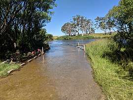 Farringdon Crossing over the Shoalhaven River | |||||||||||||||
Farringdon Location in New South Wales | |||||||||||||||
| Coordinates | 35°30′57″S 149°40′02″E | ||||||||||||||
| Population | 14 (2016 census)[1] | ||||||||||||||
| Postcode(s) | 2622 | ||||||||||||||
| Location | 17 km (11 mi) SW of Braidwood | ||||||||||||||
| LGA(s) | Queanbeyan-Palerang Regional Council | ||||||||||||||
| Region | Southern Tablelands | ||||||||||||||
| County | Murray | ||||||||||||||
| Parish | Jinero | ||||||||||||||
| State electorate(s) | Monaro | ||||||||||||||
| Federal Division(s) | Eden-Monaro | ||||||||||||||
| |||||||||||||||
References
- Australian Bureau of Statistics (27 June 2017). "Farringdon". 2016 Census QuickStats. Retrieved 19 January 2018.

- "Farringdon". Geographical Names Register (GNR) of NSW. Geographical Names Board of New South Wales. Retrieved 19 January 2018.
- "Farringdon". OpenStreetMap. Retrieved 19 January 2018.
- "Farringdon School in the School history database search". New South Wales Department of Education. Retrieved 19 January 2018.
| Queanbeyan suburbs |
|
|---|---|
| Localities and rural places |
|
Main Article: Local government areas of New South Wales | |
This article is issued from Wikipedia. The text is licensed under Creative Commons - Attribution - Sharealike. Additional terms may apply for the media files.