Pococí (canton)
Pococí is the second canton in the province of Limón in Costa Rica. The canton covers an area of 2,403.49 km²,[1] making it the third largest of Costa Rica's 81 cantons. It has a population of 125,962[2] making it seventh-ranked. Its capital in the city of Guápiles, which houses many of the canton's services and businesses.
Pococi | |
|---|---|
Cantón | |
| Country | |
| Province | Limón |
| Canton | Pococí |
| Area | |
| • Total | 2,403.49 km2 (927.99 sq mi) |
| Elevation | 262 m (860 ft) |
| Population (2011) | |
| • Total | 125,962 |
| • Density | 52/km2 (140/sq mi) |
| Time zone | UTC−06:00 |
| ZIP codes | 702 |
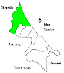
The canton takes in the Caribbean coast from the Río Toro northward to the border with Nicaragua. It ranges inland in a southwestern direction with the Río Chirripó forming the western border. The canton ends in the Cordillera Central where the Río Sucio crosses the highway in Braulio Carrillo National Park.
The Caribbean coast of Pococí boasts extensive wetlands and several protected areas, including Tortuguero National Park and Barra del Colorado Wildlife Refuge. In the Braulio Carrillo area is located the first aerial tram in the world to travel through a rainforest, called Rainforest Adventures and recently added to NatGeographic's top ten adventure trips.[3] Much of the northern portion of the canton is inundated year-round or seasonally, and inaccessible by road. The wetlands stretch inland the length of the canton. The coastal areas provide important sea turtle nesting habitat. These protected areas and wetlands are an important eco-tourism destination.
Districts
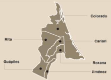
The canton of Pococí is subdivided into seven districts (distritos):
- Guápiles, postal code 70201, coordinates 10°12′56″N 83°47′32″W
- Neighborhoods (Barrios): Cecilia, Diamantes, Emilia, Floresta, Coopevigua (1,2,3), Garabito, Palmera, Los Sauces, La Urba, Toro Amarillo
- Villages (Poblados): Blanco, Calle Ángeles, Calle Gobierno, Corinto, Flores, Marina, Prado (part), Rancho Redondo, San Rafael
- Jiménez, postal code 70202, coordinates 10°12′34″N 83°44′40″W
- Neighborhoods (Barrios): Granja, Molino, Numancia, Santa Clara
- Villages (Poblados): Anita Grande, Calle Diez, Calle Emilia, Calle Seis, Calle Uno, Floritas, Parasal, San Luis, San Martín, San Valentín, Suerre
- La Rita (La Rita), postal code 70203, coordinates 10°16′52″N 83°47′10″W
- Neighborhoods (Barrios): Cruce de Jordán, Cristo Rey (La Perrera), Peligro, Pueblo Nuevo.
- Villages (Poblados): Balastre, Canta Gallo, Cayuga, Cocorí, Chirvalo, Encina, Gallopinto, Hamburgo, I Griega, Indio, Jardín, Palmitas, Porvenir, Primavera, Rótulo, San Carlos, San Cristóbal, San Pedro, Santa Elena, Sirena, Suárez, Suerte, Tarire, Teresa, Ticabán, Triángulo, Victoria, Prado
- Roxana, postal code 70204, coordinates 10°16′34″N 83°45′14″W
- Neighborhoods (Barrios): La Cruz, Punta de Riel
- Villages (Poblados): Anabán, Boca Guápiles (part), Castañal, Cruce, Curia, Curva, Curva del Humo, Esperanza, Humo, Lomas Azules, Maravilla, Mata de Limón, Millón, Milloncito, Oeste, Prado (part), Roxana Tres, San Francisco, San Jorge, Vegas de Tortuguero
- Cariari, postal code 70205, coordinates 10°22′05″N 83°44′24″W
- Neighborhoods (Barrios): San Juan, Guaria, Las Orquídeas, Los Hermanos, La Urba
- Villages (Poblados): Astúa-Pirie, Caribe, Banamola, Boca Guápiles (part), Campo Cuatro, Campo Dos, Campo Tres, Caño Chiquero, Carolina, Ceibo, Coopecariari, Cuatro Esquinas, Formosa, Frutera, Hojancha, Los Angeles, Nazaret, Palermo, Pavona, Progreso, Pueblo Triste, Sagrada Familia, Semillero, Zacatales
- Colorado (Barra del Colorado), postal code 70206, coordinates 10°46′24″N 83°35′26″W
- Neighborhoods (Barrios): Barra del Colorado Este
- Villages (Poblados): Aragón, Buenavista, Malanga, San Gerardo, Tortuguero
- La Colonia, postal code 70207
- Villages (Poblados): San Rafael, Brisas del Toro Amarillo, Cascada, La Victoria, Losilla, San Bosco, Santa Elena, Prado (Parte)
History
The canton was established by law on September 19, 1911.
See also
- Cantons of Costa Rica
- District of Guápiles
- District of Jiménez
- District of La Rita
- District of Roxana
- District of Cariari
- District of Colorado
- District of La Colonia
References
- Instituto Geográfico Nacional (IGN), 2001.
- "2011 Census Population Report" (PDF). INEC. Archived from the original (pdf) on 2017-08-07. Retrieved 2017-08-11.
- http://travel.nationalgeographic.com/travel/photos-top-10-adventure-trips/#/costa-rica-adventure-zip_86051_600x450.jpg