Zarcero (canton)
Zarcero is the 11th canton in Alajuela, a province in Costa Rica.[1] It is located west of the Costa Rican Central Valley, 67 kilometres (42 mi) northeast of the national capital, San José. The region covers an area of 155.13 square kilometers (59.90 sq mi),[2] and is divided into seven districts. To the north, the region borders canton San Carlos, to the south it borders canton Naranjo, to the east it borders canton Sarchí and to the west it borders the canton San Ramón.
Zarcero | |
|---|---|
Cantón | |
 | |
.jpg) Flag  Seal | |
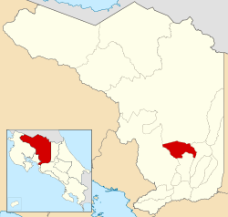 Location of Zarcero in Alajuela Province | |
| Country | Costa Rica |
| Province | Alajuela |
| Founded | 21 June 1915 |
| Area | |
| • Total | 155.13 km2 (59.90 sq mi) |
| Population (June 2013) | |
| • Total | 13,215 |
| • Density | 85/km2 (220/sq mi) |
According to the National Institute of Statistics and Censuses, in 2013 the canton Zarcero had a population of 13,215.[3] The canton has a 93% literacy rate, and by the year 2012 had a Human Development Index of 0.726 according to the United Nations Development Program. The region also has one of the lowest crime rates in the country.[4]
The economy of the canton is based on agriculture, primarily coffee and vegetables such as carrots, lettuce, potatoes and chiverre.[5] Livestock and their products, especially "natilla Zarcero", a form of sour cream that originated in this area, make up another large portion of the economy. There are also smaller pastry, bread and other agriculturally-based industries in Zarcero. Tourism likewise has an impact on the economy. Two protected areas help attract tourist attention, a section of Juan Castro Blanco National Park and El Chayote Protected Zone.[6]
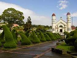
One feature of the canton is Evangelista Blanco Brenes Park, a park with topiary-designed bushes located in front of the Iglesia de San Rafael Arcángel in the center of the city of Zarcero.
The canton itself is diamond-shaped, with the Río Espina (Thornbush River) forming the border on the northwest and the southwest sides. The Río Toro (Bull River) forms the southeastern border, and the Río La Vieja (Old Woman River) borders the northeast.
Hiking trails, pure water creeks, friendly people, landscapes and natural attractions are features of the area.
Districts
The canton of Zarcero is subdivided into seven districts (distritos):[1]
| District | Postal code | Alt. (m) | Area (km2) | Pop. (2008) | Coordinates |
|---|---|---|---|---|---|
| Zarcero | 21101 | 1,736 | 12.01 | 4,376 | 10°11′08″N 84°23′39″W |
| Barrios (neighborhoods): Cantarranas, Santa Teresita | |||||
| Laguna | 21102 | 1,840 | 23.08 | 1,780 | 10°12′40″N 84°24′08″W |
| Poblados (villages): Peña | |||||
| Tapezco | 21103 | 1,821 | 6.2 | 1,227 | 10°13′10″N 84°24′16″W |
| Guadalupe | 21104 | 1,602 | 22.35 | 857 | 10°11′06″N 84°24′45″W |
| Poblados (villages): Anateri, Bellavista, Morelos | |||||
| Palmira | 21105 | 2,010 | 30.29 | 1,484 | 10°12′40″N 84°22′48″W |
| Poblados (villages): Picada | |||||
| Zapote | 21106 | 1,580 | 43.03 | 819 | 10°13′36″N 84°25′35″W |
| Poblados (villages): Quina (part), San Juan de Lajas, Santa Elena | |||||
| Brisas | 21107 | 1,850 | 18.17 | 1,825 | 10°13′53″N 84°23′40″W |
| Poblados (villages): Ángeles, Brisa, Legua | |||||
History
Zarcero was founded on June 21, 1915,[7] and was originally given the name "Alfaro Ruiz" in remembrance of Juan Alfaro Ruíz, a hero from the National Campaign of 1856,[8] or Filibuster War. The head city of the canton is the eponymous Zarcero district.
References
- "División Territorial Administrativa de Costa Rica" (PDF) (in Spanish). Instituto de Fomento y Asesoria Municipal (IFAM). 5 May 2009. Archived from the original (PDF) on August 2, 2015.
- Instituto Geográfico Nacional (IGN), 2001.
- "Estadísticas Vitales 2013" (PDF). San José, Costa Rica: Instituto Nacional de Estadistica y Censos. December 2014. Archived from the original (PDF) on April 2, 2015. Retrieved August 5, 2017.
- Mora, Andrea (April 15, 2015). "Zarcero inicia celebraciones de centenario del cantón". Elpaís.cr (in Spanish). Retrieved August 5, 2017.
- Robson, Pål André (May 2009). "Neoliberalism and Social Response: A Preliminary Study of the Peasantry in Alfaro Ruiz, Costa Rica". Retrieved August 5, 2017.
- "El Chayote Protected Zone, National Parks Costa Rica". www.costarica-nationalparks.com. Costa Rica National Parks. Retrieved August 5, 2017.
- Murillo Vargas, Juan Ramón (2015). Centenario de Zarcero: un cantón pintoresco. Costa Rica: Editorial Universidad Estatal A Distancia. ISBN 9789968481175.
- Creedman, Theodore S (1991). Historical Dictionary of Costa Rica. London: The Scarecrow Press. pp. 41–42. ISBN 9780810822153.