Vásquez de Coronado (canton)
Vásquez de Coronado, also spelled Vázquez de Coronado and commonly known as Coronado,[1] is the 11th canton in the province of San José in Costa Rica. The canton covers an area of 222.20 km²,[2] and has a population of 59,113.[3] The capital city of the canton is San Isidro.
Vásquez de Coronado | |
|---|---|
 | |
 Flag  Coat of arms | |
| Etymology: From the conquistador Juan Vasquez de Coronado | |
| Nickname(s): Coronado, Coro | |
 | |
| Coordinates: 10°4′53″N 83°58′53″W | |
| Country | Costa Rica |
| Province | San José |
| Capital | San Isidro de Coronado |
| Districts | 5 districts |
| Founded | November 15, 1910 |
| Local Celebration | 15 May, Saint Isidro Labrador's Day |
| Government | |
| • Type | Municipality |
| • Mayor | Rolando Méndez Soto (PLN) |
| Area | |
| • Total | 222 km2 (86 sq mi) |
| Elevation | 1,385 m (4,544 ft) |
| Time zone | UTC |
| Website | coromuni |
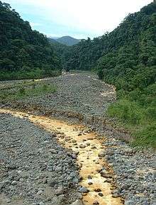
The canton of the highlands rises out of the suburbs of San José to encompass a major portion of the Cordillera Central (Central Mountain Range) and Braulio Carrillo National Park. The Río Sucio (Dirty River) forms the western boundary of the canton, while the Río Macho, Río Zurquí and Río Patria establish the canton's limits to the east. The northern tip of the canton is marked by the confluence of the Sucio and Patria rivers.
Districts
The canton of Coronado is subdivided into five districts (distritos):[1]
History
The canton was established by decree on November 15, 1910. It was named in honor of the first Spanish colonial governor of Costa Rica, Juan Vásquez de Coronado, nephew of the famous explorer Francisco Vásquez de Coronado.
Physical Landscape
The canton is geologically formed from volcanic materials associated with the Irazu and Barva volcanos. It has an irregular morphology with soils suitable for agriculture and dairy farming. The canton has high rainfall and a typical mountain climate, in fact, many Costa Ricans traditionally associate this canton with its cold climate. Coronado has a maximum altitude of 1,510 m in San Rafael district and a minimum of 1,335 m in Patalillo district. The canton has rivers that descend to the Atlantic seaboard such as Sucio, Patria and Zurquí that also serve as boundaries with the provinces of Cartago, Heredia and the canton of Moravia respectively. In the Pacific slope, the rivers Agra, Ipís and the Virilla and its tributaries (Durazno, Macho, Quebrada Varela). The rivers Ipís, Durazno and Macho serve as boundaries of the canton, the first two with Goicoechea and the last with Moravia.
Economy
The main economic activities include dairy farming, dairy and agribusiness, coffee and other agricultural products, trade, and services such tourism. The municipality has a vibrant commercial activity of the most diverse nature which involves factories, supermarkets, grocery stores, private health services, agro-veterinary services, bank branches, clothing and footwear, electrical shops, restaurants, video stores, bars and more.
Public Services
Since the fire that affected Dr. Rafael Calderon Guardia Hospital Nacional in 2005, the Coronado Integrated Health Center serves 24-hour emergency and outpatient. Emergencies of all kinds are served and the center supports Goicoechea and Moravia cantons that do not have emergency services 24 hours, or on Saturdays, Sundays or holidays. Currently the Directorate Medical Center is in charge of Dr. Rojas Cerna, and coordination of emergency services is in charge of Soto Porras, Charpantier and Rivera doctors.
Institutions
The canton of Coronado is home to important institutions such as :
- Inter-American Institute for Cooperation on Agriculture (IICA)
- National Olympic Committee
- Research Institute Clodomiro Picado Twight of the Faculty of Microbiology of the University of Costa Rica, dedicated to research with snakes and serums against the venom of these animals
- Nursing home of the Missionaries of Charity in turn serves as a base of operations in Central America
- Self-Advocates Health Association of Coronado, who owns the Home Institution Saving alcoholic and drug addict Coronado, where treatment is given on additions
- National Council for Scientific and Technological Research (CONICIT)
References
- "División Territorial Administrativa de Costa Rica" (PDF) (in Spanish). Instituto de Fomento y Asesoria Municipal (IFAM). May 5, 2009. Archived from the original (PDF) on August 2, 2015. Retrieved August 2, 2015.
- Instituto Geográfico Nacional (IGN), 2001.
- Estimates of Instituto Nacional de Estadística y Censos (INEC), May 2003.