Talamanca (canton)
Talamanca is the fourth canton in the province of Limón in Costa Rica. It is the 2nd largest of Costa Rica's 81 cantons, covering an area of 2,809.93 km2 (1,084.92 sq mi),[2] and has a population of 32,555.[3] The county is composed of four districts (see graphic below), with its capital city, Bribrí, located in the Bratsi district. Talamanca houses the largest indigenous population in the country (at 11,062, or 34% of the county's population), which is composed principally of the Bribri and Cabécar groups[3] (who in turn represent two of Costa Rica's eight distinct indigenous groups).[4]
Talamanca | |
|---|---|
 Flag | |
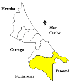 Location of Talamanca in Limón Province | |
| Country | Costa Rica |
| Province | Limón |
| Capital | Bribrí |
| Government | |
| • Mayor | Melvin Gerardo Cordero |
| Area | |
| • Total | 2,809.93 km2 (1,084.92 sq mi) |
| Population (2008) | |
| • Total | 32,555 |
| • Density | 12/km2 (30/sq mi) |
| Time zone | UTC-6 (Central Time) |
| ISO 3166-2 | CR-L |
| Google Earth[1] | |
Eight-eight percent of Talamanca's territory is protected.[5] Fifty-five percent of this land falls under the Chirripó, Amistad, and Cahuita National Parks; 31% covers Talamanca's four indigenous reserves (Kekoldi, Talamanca Bribrí, Talamanca Cabécar, and Telire); and 2% belongs to the Refugio de Vida Silvestre Gandoca Manzanillo national "reserve" (a major tortoise breeding ground).[5]
The Costa Rican government is highly aggressive (albeit a bit slow to act) in its protection of these lands. On July 27, 2011, for example, the Ministerio de Ambiente, Energía y Telecomunicaciones (Minaet) carried out the demolition of two hotels (Las Palmas and Suerre), due to their occupation of 4 hectares of land within the Refugio de Vida Silvestre Gandoca Manzanillo.[6] This demolition was the culmination of events starting in 1993, when Minaet revoked these hotels' permission of occupation.[6]
The county suffers from pervasive poverty. As of 2009, its human-development index is the lowest-ranked of all Costa Rican cantons.[7] While its most recent infant mortality rate is 12.89% (2009), it was as high as 22.5% (2003), and stayed above 15% between 2003 and 2007.[8] As of 2010, 52.3% of Talamanca inhabitants have access to sanitation (either piped or septic tank), and 75.2% are connected to electricity.[9]
Talamanca contains one of Costa Rica's three official border-crossing points (Sixaola-Guabito). The county is noted for its beautiful beaches, especially in Cahuita and Puerto Viejo (Old Harbor), which are popular tourist locations.
Districts
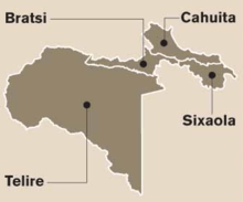
The canton of Talamanca is subdivided into four districts (distritos):[10]
| District | Territorial code | Alt. (m) | Area (km2) | Pop. (2008) | Coordinates | Capital |
|---|---|---|---|---|---|---|
| Bratsi | 70401 | 32 | 179.25 | 5,620 | 09°37′35″N 82°51′14″W | Bribri |
| Barrios Fields, Sand Box. | ||||||
| Poblados: Altamira, Akberie (Piedra Grande), Bambú, Chase, Cuabre, Gavilán Canta, Mleyuk 1, Mleyuk 2, Monte Sión, Olivia, Hu-Berie (Rancho Grande), Shiroles, Sibujú, Suretka, Uatsi. | ||||||
| Sixaola | 70402 | 10 | 171.78 | 12,437 | 09°30′10″N 82°36′55″W | |
| Poblados: Ania, Boca Sixaola, Catarina, Celia, Daytonia, Gandoca, Margarita, Mata de Limón, Noventa y Seis, Palma, Paraíso, Parque, San Miguel, San Miguelito, San Rafael, Virginia, Zavala. | ||||||
| Cahuita | 70403 | 4 | 235.64 | 6,546 | 09°44′22″N 82°50′32″W | |
| Poblados: Buenavista (Katuir), Bordón, Carbón, Carbón 1, Carbón 2, Catarata, Cocles, Comadre, Dindirí, Gibraltar, Hone Creek, Hotel Creek, Kekoldi, Limonal, Manzanillo, Mile Creek, Patiño, Playa Chiquita, Puerto Viejo, Punta Caliente, Punta Cocles, Punta Mona, Punta Uva, Tuba Creek (Parte). | ||||||
| Telire | 70404 | 70 | 2223.26 | 7,555 | 09°31′10″N 82°57′22″W | Amubri |
| Poblados: Alto Cuen (Kjacka Bata), Alto Lari (Duriñak), Alto Urén, Arenal, Bajo Blei, Bajo Cuen, Boca Urén, Bris, Cachabli, Coroma, Croriña, China Kichá, Dururpe, Guachalaba, Katsi, Kichuguecha, Kivut, Mojoncito, Namuwakir, Orochico, Ourut, Purisquí, Purita, Rangalle, San José Cabecar, Sepeque, Shewab, Sipurio, Soky, Sorókicha, Sukut, Surayo, Suiri, Telire, Turubokicha, Urén. | ||||||
History
The canton was established by law on May 20, 1969.
References
- Google Earth
- Insituto Nacional de Estadística y Censos (INEC). (2008). Área en kilometros cuadrados, según provincia, cantón, y distrito administrativo. Retrieved from http://www.inec.go.cr
- Insituto Nacional de Estadística y Censos (INEC). (2008). Población estimada cerrada según provincia, cantón, y distrito al 31 de diciembre de cada año, 2002-2008. Retrieved from http://www.inec.go.cr
- Organización de las Naciones Unidas para la Eduación, la Cienca, y la Cultura (UNESCO). (2011). Grupos indígenas. Retrieved from http://www.unesco.or.cr/portalcultural/indigenas.htm
- Gudiño, A. (2007, June 21). Denuncian actividad minera de extranjeros en reserva indígena de Costa Rica. La Nación (Costa Rica). Retrieved from http://wvw.nacion.com/ln_ee/2007/junio/21/ultima-sr1141448.html
- Imperio de la ley en Gandoca-Manzanillo. (2011, July 27). La Nación (Costa Rica). Retrieved from http://www.nacion.com/2011-07-28/Opinion/imperio-de-la-ley-en-gandoca-manzanillo.aspx
- Álvaros, A.R. (2009, October 11). El miedo atracó en Limón. La Nación (Costa Rica). Retrieved from http://wvw.nacion.com/proa/2009/octubre/11/proa2113441.html
- Insituto Nacional de Estadística y Censos (INEC). (2009). Anuario Estadístico 2009. Retrieved from http://www.inec.go.cr
- Insituto Nacional de Estadística y Censos (INEC). (2010). Cuadro No 39: Indicadores de vividena, según provincia, cantón, y distrito. Retrieved from http://www.inec.go.cr
- "División Territorial Administrativa de Costa Rica" (PDF) (in Spanish). Instituto de Fomento y Asesoria Municipal (IFAM). 5 May 2009. Archived from the original (PDF) on 2 August 2015.