Pasacao, Camarines Sur
Pasacao, officially the Municipality of Pasacao, is a 3rd class municipality in the province of Camarines Sur, Philippines. According to the 2015 census, it has a population of 49,035 people.[3]
Pasacao | |
|---|---|
| Municipality of Pasacao | |
 Aerial shot of Pasacao with its port and oil depot. | |
 Seal | |
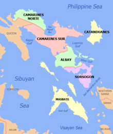
 Map of Camarines Sur with Pasacao highlighted | |

| |
.svg.png) Pasacao Location within the Philippines | |
| Coordinates: 13°31′N 123°03′E | |
| Country | |
| Region | Bicol Region (Region V) |
| Province | Camarines Sur |
| District | 2nd district |
| Barangays | 19 (see Barangays) |
| Government | |
| • Type | Sangguniang Bayan |
| • Mayor | Niño A. Tayco |
| • Vice Mayor | Marilyn H. Sotto |
| • Congressman | Luis Raymund F. Villafuerte Jr. |
| • Electorate | 30,183 voters (2019) |
| Area | |
| • Total | 149.54 km2 (57.74 sq mi) |
| Elevation | 4.8 m (15.7 ft) |
| Population (2015 census)[3] | |
| • Total | 49,035 |
| • Density | 330/km2 (850/sq mi) |
| • Households | 9,838 |
| Economy | |
| • Income class | 3rd municipal income class |
| • Poverty incidence | 41.62% (2015)[4] |
| • Revenue (₱) | 118,638,800.75 (2016) |
| Time zone | UTC+8 (PST) |
| ZIP code | 4417 |
| PSGC | |
| IDD : area code | +63 (0)54 |
| Climate type | tropical rainforest climate |
| Native languages | Central Bikol Tagalog |
Barangays
Pasacao is politically subdivided into 19 barangays.
History

Pasacao was the slumbering "visita" and served as the only existing port of the Bicol Region. The Spaniards who set foot in Bicol late in 16th century noted the importance of the visita in their exploration. Pasacao became a strategic defense port against the raids by Moro pirates from 1585 to 19th century. Due to frequent raids the town had an estimated population of only 200 in 1823.
Vessels carrying goods and passengers made their starts or stop over here. Notwithstanding the rough road to Pamplona, this town has been contributing to, a large degree, in the economic development of the province of the Camarines Sur in particular.
Pasacao's strategic location along the rugged coast of the vast expanse of the Ragay Gulf in the east made it very important to the economic and social life of the people of the region. It is for the reason that a parish was established dedicated to the Saint Rose of Lima as the patroness. Annually in the honor of the town patroness, a fiesta is celebrated on August 30.
It is said that the geography of Pasacao makes its history full of hardships, troubles and affliction that influenced the customs, traditions and way of life of the inhabitants. The continued Moro piracy likes that one in 4 October 1779 at Caranan. The report of Bishop Manuel dela Concepcion described these raids in his letter to the King on June 29, 1758 as "undoubtedly greater at any other time." (Raids in 1757). The raids according to Domingo Abella-Bikol Annals, "ten towns and two missions were completely destroyed; ten churches were looted and burned; about 8,000 indios were captured or killed; one priest was killed, two captured, and the capital Caceres, was under alert one night. Alcalde Jacinto Rodriguez Morales provided material for a baluarte (earthwork or fortified rampant) as defense of Pasacao against these raids. He also issued rations to bantayes (watchmen, sentinels).
The port of Pasacao is rich in stories on how it got its present name. Since the part is a bustling area, dockguards were stationed to maintain peace and order. These guards would usually shout "Pasa ikaw, Pasa ikaw" as instructions to passengers. This Spanish-Tagalog mixed up "pasa-ikaw" was mistaken by the passengers as the name of the place - Pasacao.
Another story went around that fisherman who was asked by a Spanish sentry what were the contents of his basket. The fisherman answered "pasa-pasa", the name of the fish, and simultaneously offered some by saying "ikaw" meaning to say if he wanted some. The sentry on the other hand interpreted the words "Pasa-pasa ikaw" as the name of the place. For long, the place was known among the soldiers as Pasa-pasa ikaw until it shortened to a more convenient Pasacao.
The town's name was also said to have been derived from "Pasok kayo". This came from a native as an answer to a Spanish soldier's query of the name of the place. Misunderstanding clouded the native's remark when he meant to say that the soldier come up or come in.
In a similar story as the first story, Pasacao came from "Pasa ikaw". Some Spanish settlers while walking along the shore met a native. The settlers asked the native to pass on by saying "Pasa". The native, on the other hand, wanted the Spaniards to go first by saying "ikaw". Through a convenient usage, it became Pasacao.
Still another story gives credence to the word "Pasangkay" as the origin of the town's name. The travelers and traders often used it en route to Manila to ask owners of the sailboats along the shore of the village to let them ride. Pasangkay means the request of the people to get into the boat to travel.
From the above-mentioned short atories, the name of the town Pasacao must have been derived from them.
The Fil-American or Spanish law recognizing the legal existence of Pasacao believes. Church records however say that the founding of the church was 1885.
Very few people of Pasacao except the old during the governorship of Juan de Silva (1609–1626) two galleons (Manila-Acapulco trade) were constructed in the astillero at the Lupaon (or Dalupaon nowadays) Pasacao. They were Nuestra Señora de Guadalupe and the Angel dele Guardia. According to our BiKol historian Jose Calleja Reyes, the galleon "Guadalupe" figured both in the galleon trade between Manila and Acapulco and in the defense of the Philippines against Dutch incursion in the naval battle of Playa Honda.
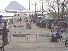
Other important historical events that unfolded the Pasacao still left them landmark. The Pasacao Pier was the dockyard of the Japanese ships when it was bombed. Until now some of the Japanese ships can be seen under clear waters. The first place where the AMerican landed is the Magtabid Beach in Pasacao. American air transportation first landed in Tinalmud with their Grasshoppers in 1945. The Pasacao seashore was the place where the Six Daughters of Charity (nuns) landed from Spain to establish the first normal school for girls which is now the Colegio de Santa Isabel in Naga City. These and many other events took place in this town.
During the early American school administrators used this port as their landing. When going to manila they had to sail from here. With no roads from Naga City they used to be carried in the hammock by hired men traversing the mountain trails. In spite of the importance of Pasacao-Pamplona road the authorities have been slow improving it. It took three days on foot from Pasacao to Naga back and forth during the late 19th century.
Demographics

| Population census of Pasacao | ||
|---|---|---|
| Year | Pop. | ±% p.a. |
| 1903 | 2,431 | — |
| 1918 | 2,308 | −0.35% |
| 1939 | 5,594 | +4.31% |
| 1948 | 8,128 | +4.24% |
| 1960 | 14,327 | +4.84% |
| 1970 | 19,355 | +3.05% |
| 1975 | 21,809 | +2.42% |
| 1980 | 25,303 | +3.02% |
| 1990 | 31,960 | +2.36% |
| 1995 | 36,070 | +2.29% |
| 2000 | 38,423 | +1.36% |
| 2007 | 41,533 | +1.08% |
| 2010 | 45,946 | +3.74% |
| 2015 | 49,035 | +1.25% |
| Source: Philippine Statistics Authority[3][5][6][7] | ||
In the 2015 census, the population of Pasacao was 49,035 people,[3] with a density of 330 inhabitants per square kilometre or 850 inhabitants per square mile.
Language
While Tagalog is the national language of the Philippines and English is common to the business sectors, these languages are rarely spoken as a medium of communication in Pasacao. Bicol Naga is the language or dialect being spoken by most of its people.
Climate

The municipality belongs to the fourth distinct type of climate. Rainfall is evenly distributed throughout the year with north-east monsoon prevailing in the area. The general direction of the wind is characteristically from north to east from October to January and from east to southeast from February to April and easterly from May to September. The area is relatively dry from December to May and wet for the rest of the year.
From February to May is hot and dry season in the Philippines and Pasacao in particular. From this months most visitors and tourists come to Pasacao to unwind. It is during the "Lingo ng Pagkabuhay" or the Easter Sunday that most resorts and beaches are fully loaded with visitors coming from nearby places and other areas of the world.
| Climate data for Pasacao, Camarines Sur | |||||||||||||
|---|---|---|---|---|---|---|---|---|---|---|---|---|---|
| Month | Jan | Feb | Mar | Apr | May | Jun | Jul | Aug | Sep | Oct | Nov | Dec | Year |
| Average high °C (°F) | 33 (91) |
31 (88) |
35 (95) |
37 (99) |
38 (100) |
37 (99) |
36 (97) |
34 (93) |
35 (95) |
34 (93) |
33 (91) |
32 (90) |
35 (94) |
| Average low °C (°F) | 27 (81) |
27 (81) |
29 (84) |
31 (88) |
32 (90) |
32 (90) |
30 (86) |
29 (84) |
30 (86) |
29 (84) |
28 (82) |
28 (82) |
29 (85) |
| Average precipitation mm (inches) | 137.19 (5.40) |
44.2 (1.74) |
52.17 (2.05) |
45.43 (1.79) |
54.15 (2.13) |
92.29 (3.63) |
182.23 (7.17) |
289.11 (11.38) |
260.6 (10.26) |
180.07 (7.09) |
340.22 (13.39) |
98.7 (3.89) |
1,776.36 (69.92) |
| Average rainy days | 25 | 21 | 22 | 19 | 19 | 24 | 26 | 30 | 29 | 27 | 29 | 24 | 295 |
| Source: World Weather Online[8] | |||||||||||||
References
- "Municipality". Quezon City, Philippines: Department of the Interior and Local Government. Retrieved 31 May 2013.
- "Province: Camarines Sur". PSGC Interactive. Quezon City, Philippines: Philippine Statistics Authority. Retrieved 12 November 2016.
- Census of Population (2015). "Region V (Bicol Region)". Total Population by Province, City, Municipality and Barangay. PSA. Retrieved 20 June 2016.
- "PSA releases the 2015 Municipal and City Level Poverty Estimates". Quezon City, Philippines. Retrieved 1 January 2020.
- Census of Population and Housing (2010). "Region V (Bicol Region)". Total Population by Province, City, Municipality and Barangay. NSO. Retrieved 29 June 2016.
- Censuses of Population (1903–2007). "Region V (Bicol Region)". Table 1. Population Enumerated in Various Censuses by Province/Highly Urbanized City: 1903 to 2007. NSO.
- "Province of Camarines Sur". Municipality Population Data. Local Water Utilities Administration Research Division. Retrieved 17 December 2016.
-
"Pasacao, Camarines Sur: Average Temperatures and Rainfall". World Weather Online. Missing or empty
|url=(help)
External links
| Wikimedia Commons has media related to Pasacao. |
- Pasacao Profile at PhilAtlas.com
- Official Website of Pasacao, Camarines Sur
- Philippine Standard Geographic Code
- Philippine Census Information
- Official Site of the Province of Camarines Sur
Places adjacent to Pasacao, Camarines Sur | ||||||||||
|---|---|---|---|---|---|---|---|---|---|---|
| ||||||||||
Statistically grouped with the Province of Camarines Sur | ||||||
| Administrative divisions |
|  | ||||
| Geography | ||||||
| History | ||||||
| Religion |
| |||||
| Public utilities and services |
| |||||
| Transportation | ||||||
| Education |
| |||||
| Landmarks | ||||||
Pili (capital) | |
| Municipalities | |
| Component city | |
| Independent component city |
|