Bula, Camarines Sur
Bula, (Rinconada Bikol: Banwaān ka Bula; Tagalog: Bayan ng Bula), officially the Municipality of Bula, is a 2nd class municipality in the province of Camarines Sur, Philippines. According to the 2015 census, it has a population of 69,430 people.[3]
Bula | |
|---|---|
| Municipality of Bula | |
 | |
 Seal | |
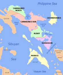
 Map of Camarines Sur with Bula highlighted | |
OpenStreetMap 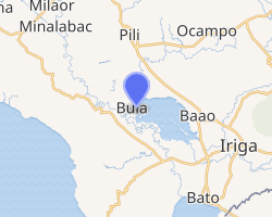
| |
.svg.png) Bula Location within the Philippines | |
| Coordinates: 13°28′N 123°17′E | |
| Country | |
| Region | Bicol Region (Region V) |
| Province | Camarines Sur |
| District | 5th district |
| Barangays | 33 (see Barangays) |
| Government | |
| • Type | Sangguniang Bayan |
| • Mayor | Amelita A. Ibasco |
| • Vice Mayor | Nilo C. Malanyaon II |
| • Congressman | Jocelyn F. Fortuno |
| • Electorate | 40,794 voters (2019) |
| Area | |
| • Total | 167.64 km2 (64.73 sq mi) |
| Elevation | 11.8 m (38.7 ft) |
| Population (2015 census)[3] | |
| • Total | 69,430 |
| • Density | 410/km2 (1,100/sq mi) |
| • Households | 13,482 |
| Economy | |
| • Income class | 2nd municipal income class |
| • Poverty incidence | 45.45% (2015)[4] |
| • Revenue (₱) | 148,123,781.66 (2016) |
| Time zone | UTC+8 (PST) |
| ZIP code | 4430 |
| PSGC | |
| IDD : area code | +63 (0)54 |
| Climate type | tropical rainforest climate |
| Native languages | Rinconada Bikol Central Bikol Tagalog |
| Website | www |
The town of Bula is historically considered as one of the first four towns of Camarines Sur founded by the Spanish conquistadores when they set foot on the Bicol soil coming from the Visayas, 1576. The other premier towns were Naga, Quipayo and Nabua. The Spaniards who first came to this place asked the men who were splitting bamboos about the name of the place, and since they did not understand the language, they thought that they were being asked about the name of the bamboo, and so they got the answer "Bu-la". And so Bula became the name of the town.
Geography
Bula is bounded on the north by the municipalities of Pili and Ocampo, on the east by the municipality of Baao, on the southeast by the Municipality of Nabua, on the south it is bounded by the Municipality of Balataan, on the southwest by Ragay Gulf, and on the west by the Municipality of Minalabac. It is approximately 25 kilometres (16 mi) southwest of Naga City.
Barangays
Bula is politically subdivided into 33 barangays.
- Bagoladio
- Bagumbayan
- Balaogan
- Caorasan
- Casugad
- Causip
- Fabrica
- Inoyonan
- Itangon
- Kinalabasahan
- La Purisima
- La Victoria
- Lanipga
- Lubgan
- Ombao Heights
- Ombao Polpog
- Palsong
- Panoypoyan
- Pawili
- Sagrada (Sagrada Familia)
- Salvacion (Poblacion)
- San Agustin
- San Francisco
- San Isidro
- San Jose
- San Miguel
- San Ramon
- San Roque (Poblacion)
- San Roque Heights
- Santa Elena
- Santo Domingo
- Santo Niño
- Taisan
Climate
| Climate data for Bula, Camarines Sur | |||||||||||||
|---|---|---|---|---|---|---|---|---|---|---|---|---|---|
| Month | Jan | Feb | Mar | Apr | May | Jun | Jul | Aug | Sep | Oct | Nov | Dec | Year |
| Average high °C (°F) | 33 (91) |
32 (90) |
36 (97) |
37 (99) |
38 (100) |
37 (99) |
35 (95) |
33 (91) |
35 (95) |
34 (93) |
33 (91) |
32 (90) |
35 (94) |
| Average low °C (°F) | 27 (81) |
27 (81) |
29 (84) |
31 (88) |
32 (90) |
32 (90) |
31 (88) |
29 (84) |
30 (86) |
29 (84) |
28 (82) |
28 (82) |
29 (85) |
| Average precipitation mm (inches) | 36.63 (1.44) |
49.6 (1.95) |
46.66 (1.84) |
78.81 (3.10) |
93.81 (3.69) |
135.51 (5.34) |
326.31 (12.85) |
406.1 (15.99) |
214.85 (8.46) |
313.98 (12.36) |
76.2 (3.00) |
262 (10.3) |
2,040.46 (80.32) |
| Average rainy days | 19 | 23 | 17 | 19 | 23 | 27 | 31 | 29 | 27 | 29 | 24 | 29 | 297 |
| Source: World Weather Online[5] | |||||||||||||
History
The Municipality of Bula is historically one of the first four mission towns of Camarines Sur founded by Spanish conquistadores in 1576. Bula was established together with Quipayo, Naga and Nabua. However, it was only in 1578 when the natives where Christianized, so the National Historical Commission dates back our history to 1578. From this historical fact, Bula, whose chosen Saint is St. Mary Magdalene celebrates its fiesta every 22nd day of July, which is the birthdate of the Saint.
Demographics
| Population census of Bula | |||||||||||||||||||||||||||||||||||||||||||||||||
|---|---|---|---|---|---|---|---|---|---|---|---|---|---|---|---|---|---|---|---|---|---|---|---|---|---|---|---|---|---|---|---|---|---|---|---|---|---|---|---|---|---|---|---|---|---|---|---|---|---|
|
| ||||||||||||||||||||||||||||||||||||||||||||||||
| Source: Philippine Statistics Authority[3][6][7][8] | |||||||||||||||||||||||||||||||||||||||||||||||||
In the 2015 census, the population of Bula, Camarines Sur, was 69,430 people,[3] with a density of 410 inhabitants per square kilometre or 1,100 inhabitants per square mile.
Language
Majority of the people speak the Bula-Pili variant, a lowland dialect (sinaranəw) of Rinconada Bikol language, also known as Riŋkonāda. The population can also understand and speak Tagalog or Filipino language and English.
Religion
People of Bula are divided into different Christian sects. Most of the population are Roman Catholic and Iglesia ni Cristo members which are the biggest bulk of Bulaeños adhering to Christian faith. The rest of population are followers of different Protestant denominations.
Tourist Spots
The town of Bula is the home of the breath-taking views of Tan-Awan Park, Nalalata Falls, and Burabod. Tan-Awan Park, located in Barangay Bagoladio atop a hill, attracts a number of tourists because of its captivating view overlooking the areas of its neighboring towns in Rinconada.
Gallery
 Bula Municipal Building
 St. Mary Magdalene Parish Church
 Bula Catholic Cemetery
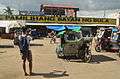 Bula Public Market
 Bula National High School
 Nalalata Cave
 Nalalata Falls
 Bula Parochial School

References
- "Municipality". Quezon City, Philippines: Department of the Interior and Local Government. Retrieved 31 May 2013.
- "Province: Camarines Sur". PSGC Interactive. Quezon City, Philippines: Philippine Statistics Authority. Retrieved 12 November 2016.
- Census of Population (2015). "Region V (Bicol Region)". Total Population by Province, City, Municipality and Barangay. PSA. Retrieved 20 June 2016.
- "PSA releases the 2015 Municipal and City Level Poverty Estimates". Quezon City, Philippines. Retrieved 1 January 2020.
- ", Camarines Sur: Average Temperatures and Rainfall". World Weather Online. Retrieved 29 October 2017.
- Census of Population and Housing (2010). "Region V (Bicol Region)". Total Population by Province, City, Municipality and Barangay. NSO. Retrieved 29 June 2016.
- Censuses of Population (1903–2007). "Region V (Bicol Region)". Table 1. Population Enumerated in Various Censuses by Province/Highly Urbanized City: 1903 to 2007. NSO.
- "Province of Camarines Sur". Municipality Population Data. Local Water Utilities Administration Research Division. Retrieved 17 December 2016.
External links
| Wikimedia Commons has media related to Bula, Camarines Sur. |
- Bula Profile at PhilAtlas.com
- Philippine Standard Geographic Code
- Philippine Census Information
- Official Site of the Province of Camarines Sur
Statistically grouped with the Province of Camarines Sur | ||||||
| Administrative divisions |
|  | ||||
| Geography | ||||||
| History | ||||||
| Religion |
| |||||
| Public utilities and services |
| |||||
| Transportation | ||||||
| Education |
| |||||
| Landmarks | ||||||
Pili (capital) | |
| Municipalities | |
| Component city | |
| Independent component city |
|