Sagñay
Sagñay, [ˈsaŋaj], officially the Municipality of Sagñay, is a 4th class municipality in the province of Camarines Sur, Philippines. According to the 2015 census, it has a population of 34,546 people.[4]
Sagñay | |
|---|---|
| Municipality of Sagñay | |
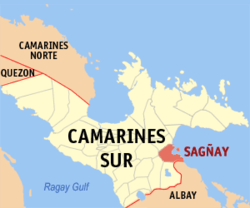 Map of Camarines Sur with Sagñay highlighted | |
OpenStreetMap 
| |
.svg.png) Sagñay Location within the Philippines | |
| Coordinates: 13°36′N 123°31′E | |
| Country | |
| Region | Bicol Region (Region V) |
| Province | Camarines Sur |
| District | 4th district |
| Founded | November 30, 1684 |
| Barangays | 19 (see Barangays) |
| Government | |
| • Type | Sangguniang Bayan |
| • Mayor | John Vincent B. Fuentebella |
| • Vice Mayor | Harold Bryan A. San Felipe |
| • Congressman | Arnulf Bryan B. Fuentebella |
| • Electorate | 20,731 voters (2019) |
| Area | |
| • Total | 154.76 km2 (59.75 sq mi) |
| Elevation | 11.6 m (38.1 ft) |
| Population (2015 census)[4] | |
| • Total | 34,546 |
| • Density | 220/km2 (580/sq mi) |
| • Households | 6,947 |
| Economy | |
| • Income class | 4th municipal income class |
| • Poverty incidence | 44.21% (2015)[5] |
| • Revenue (₱) | 89,408,012.25 (2016) |
| Time zone | UTC+8 (PST) |
| ZIP code | 4421 |
| PSGC | |
| IDD : area code | +63 (0)54 |
| Climate type | tropical rainforest climate |
| Native languages | Central Bikol Tagalog |
Atulayan Island is under the jurisdiction of this municipality.
History
Sagñay was established in the late 17th century by the Spanish friars. Like the town of Lagonoy, Sañgay also formed part of the province of Albay but it was separated in the year 1846 by the order of Governor General Narciso Claveria.
The parish of St. Andrew was founded in the same year that Sagñay gained its independence as a town. The town's annual fiesta is held every November 30.Based from Atanacio.
Barangays
Sagñay is subdivided into 19 barangays.
Demographics
| Population census of Sagñay | ||
|---|---|---|
| Year | Pop. | ±% p.a. |
| 1918 | 5,429 | — |
| 1939 | 7,052 | +1.25% |
| 1948 | 8,378 | +1.93% |
| 1960 | 14,004 | +4.37% |
| 1970 | 16,968 | +1.94% |
| 1975 | 18,013 | +1.21% |
| 1980 | 20,241 | +2.36% |
| 1990 | 22,422 | +1.03% |
| 1995 | 26,530 | +3.20% |
| 2000 | 26,619 | +0.07% |
| 2007 | 29,082 | +1.23% |
| Source: Philippine Statistics Authority[4][6][7][8] | ||
In the 2015 census, the population of Sagñay, Camarines Sur, was 34,546 people,[4] with a density of 220 inhabitants per square kilometre or 570 inhabitants per square mile.
Climate
| Climate data for Sagñay, Camarines Sur | |||||||||||||
|---|---|---|---|---|---|---|---|---|---|---|---|---|---|
| Month | Jan | Feb | Mar | Apr | May | Jun | Jul | Aug | Sep | Oct | Nov | Dec | Year |
| Average high °C (°F) | 31 (88) |
30 (86) |
32 (90) |
35 (95) |
35 (95) |
35 (95) |
34 (93) |
33 (91) |
34 (93) |
32 (90) |
30 (86) |
30 (86) |
33 (91) |
| Average low °C (°F) | 26 (79) |
26 (79) |
28 (82) |
30 (86) |
31 (88) |
30 (86) |
29 (84) |
29 (84) |
29 (84) |
28 (82) |
27 (81) |
27 (81) |
28 (83) |
| Average precipitation mm (inches) | 252.8 (9.95) |
82.88 (3.26) |
137.93 (5.43) |
63.69 (2.51) |
78.31 (3.08) |
229.42 (9.03) |
288.31 (11.35) |
280.99 (11.06) |
112.39 (4.42) |
210.87 (8.30) |
599.07 (23.59) |
194.80 (7.67) |
2,531.46 (99.65) |
| Average rainy days | 29 | 24 | 28 | 18 | 20 | 24 | 29 | 31 | 27 | 27 | 30 | 29 | 316 |
| Source: World Weather Online[9] | |||||||||||||
References
- "Municipality". Quezon City, Philippines: Department of the Interior and Local Government. Retrieved 31 May 2013.
- "Province: Camarines Sur". PSGC Interactive. Quezon City, Philippines: Philippine Statistics Authority. Retrieved 12 November 2016.
- "Sagñay, Camarines Sur Profile". PhilAtlas.com. Retrieved 15 June 2020.
- Census of Population (2015). "Region V (Bicol Region)". Total Population by Province, City, Municipality and Barangay. PSA. Retrieved 20 June 2016.
- "PSA releases the 2015 Municipal and City Level Poverty Estimates". Quezon City, Philippines. Retrieved 1 January 2020.
- Census of Population and Housing (2010). "Region V (Bicol Region)". Total Population by Province, City, Municipality and Barangay. NSO. Retrieved 29 June 2016.
- Censuses of Population (1903–2007). "Region V (Bicol Region)". Table 1. Population Enumerated in Various Censuses by Province/Highly Urbanized City: 1903 to 2007. NSO.
- "Province of Camarines Sur". Municipality Population Data. Local Water Utilities Administration Research Division. Retrieved 17 December 2016.
-
"Sagnay, Camarines Sur: Average Temperatures and Rainfall". World Weather Online. Missing or empty
|url=(help)
External links
Places adjacent to Sagñay | ||||||||||
|---|---|---|---|---|---|---|---|---|---|---|
| ||||||||||
Pili (capital) | |
| Municipalities | |
| Component city | |
| Independent component city |
|