Palanas, Masbate
Palanas, officially the Municipality of Palanas, is a 4th class municipality in the province of Masbate, Philippines. According to the 2015 census, it has a population of 26,222 people.[3]
Palanas | |
|---|---|
| Municipality of Palanas | |
 Seal | |
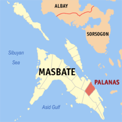 Map of Masbate with Palanas highlighted | |
| |
.svg.png) Palanas Location within the Philippines | |
| Coordinates: 12°09′N 123°55′E | |
| Country | |
| Region | Bicol Region (Region V) |
| Province | Masbate |
| District | 3rd district |
| Founded | 1951 |
| Barangays | 24 (see Barangays) |
| Government | |
| • Type | Sangguniang Bayan |
| • Mayor | Roscelle A. Eramiz |
| • Vice Mayor | Rudy L. Alvarez |
| • Congressman | Wilton T. Kho |
| • Electorate | 18,017 voters (2019) |
| Area | |
| • Total | 171.10 km2 (66.06 sq mi) |
| Elevation | 9.5 m (31.2 ft) |
| Population (2015 census)[3] | |
| • Total | 26,222 |
| • Density | 150/km2 (400/sq mi) |
| • Households | 5,843 |
| Economy | |
| • Income class | 4th municipal income class |
| • Poverty incidence | 44.73% (2015)[4] |
| • Revenue (₱) | 84,332,716.15 (2016) |
| Time zone | UTC+8 (PST) |
| ZIP code | 5404 |
| PSGC | |
| IDD : area code | +63 (0)56 |
| Climate type | tropical rainforest climate |
| Native languages | Masbateño language Tagalog |
Palanas was created in 1951 from the barrios of Palanas, Nipa, Nabangig, Banco, Pina, Maanahao, Salvacion, Antipolo, Malatawan, Intusan, Miabas, San Antonio, Libtong, Malibas, Santa Cruz, Bontod and Cabil-isan of Dimasalang.[5] It annually celebrates "Pasayaw sa Leon" Festival (The Lion Dance Festival) every 19 December.
Barangays
Palanas is politically subdivided into 24 barangays. [2]
- Antipolo
- Banco
- Biga-a
- Bontod
- Buenasuerte
- Intusan
- Jose A. Abenir Sr. (Libtong)
- Maanahao
- Mabini
- Malibas
- Maravilla
- Matugnao
- Miabas
- Nabangig
- Nipa
- Parina
- Piña
- Poblacion
- Salvacion
- San Antonio
- San Carlos
- San Isidro
- Santa Cruz
- Malatawan
Climate
| Climate data for Palanas, Masbate | |||||||||||||
|---|---|---|---|---|---|---|---|---|---|---|---|---|---|
| Month | Jan | Feb | Mar | Apr | May | Jun | Jul | Aug | Sep | Oct | Nov | Dec | Year |
| Average high °C (°F) | 29 (84) |
29 (84) |
31 (88) |
32 (90) |
32 (90) |
31 (88) |
30 (86) |
30 (86) |
30 (86) |
30 (86) |
29 (84) |
29 (84) |
30 (86) |
| Average low °C (°F) | 23 (73) |
22 (72) |
23 (73) |
23 (73) |
25 (77) |
25 (77) |
24 (75) |
25 (77) |
24 (75) |
24 (75) |
24 (75) |
23 (73) |
24 (75) |
| Average precipitation mm (inches) | 39 (1.5) |
34 (1.3) |
42 (1.7) |
36 (1.4) |
73 (2.9) |
109 (4.3) |
118 (4.6) |
108 (4.3) |
129 (5.1) |
136 (5.4) |
112 (4.4) |
89 (3.5) |
1,025 (40.4) |
| Average rainy days | 12.6 | 9.7 | 12.0 | 13.0 | 20.5 | 25.3 | 26.2 | 24.8 | 25.2 | 25.9 | 21.9 | 17.9 | 235 |
| Source: Meteoblue [6] | |||||||||||||
Demographics
| Population census of Palanas | ||||||||||||||||||||||||||||||||||||||||
|---|---|---|---|---|---|---|---|---|---|---|---|---|---|---|---|---|---|---|---|---|---|---|---|---|---|---|---|---|---|---|---|---|---|---|---|---|---|---|---|---|
|
| |||||||||||||||||||||||||||||||||||||||
| Source: Philippine Statistics Authority[3][7][8][9] | ||||||||||||||||||||||||||||||||||||||||
In the 2015 census, the population of Palanas, Masbate, was 26,222 people,[3] with a density of 150 inhabitants per square kilometre or 390 inhabitants per square mile.
References
- "Municipality". Quezon City, Philippines: Department of the Interior and Local Government. Retrieved 31 May 2013.
- "Province: Masbate". PSGC Interactive. Quezon City, Philippines: Philippine Statistics Authority. Retrieved 12 November 2016.
- Census of Population (2015). "Region V (Bicol Region)". Total Population by Province, City, Municipality and Barangay. PSA. Retrieved 20 June 2016.
- "PSA releases the 2015 Municipal and City Level Poverty Estimates". Quezon City, Philippines. Retrieved 1 January 2020.
- "An Act Creating the Municipality of Palanas in the Province of Masbate". LawPH.com. Retrieved 2011-04-09.
- "Palanas: Average Temperatures and Rainfall". Meteoblue. Retrieved 23 June 2020.
- Census of Population and Housing (2010). "Region V (Bicol Region)". Total Population by Province, City, Municipality and Barangay. NSO. Retrieved 29 June 2016.
- Censuses of Population (1903–2007). "Region V (Bicol Region)". Table 1. Population Enumerated in Various Censuses by Province/Highly Urbanized City: 1903 to 2007. NSO.
- "Province of Masbate". Municipality Population Data. Local Water Utilities Administration Research Division. Retrieved 17 December 2016.
External links
- Palanas Profile at PhilAtlas.com
- Philippine Standard Geographic Code
- Philippine Census Information
- Local Governance Performance Management System
Masbate City (capital) | |
| Municipalities | |
| Component city | |
This article is issued from Wikipedia. The text is licensed under Creative Commons - Attribution - Sharealike. Additional terms may apply for the media files.