Siruma, Camarines Sur
Siruma, officially the Municipality of Siruma, is a 4th class municipality in the province of Camarines Sur, Philippines. According to the 2015 census, it has a population of 17,764 people.[3]
Siruma | |
|---|---|
| Municipality of Siruma | |
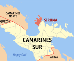 Map of Camarines Sur with Siruma highlighted | |
| |
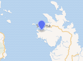
.svg.png) Siruma Location within the Philippines | |
| Coordinates: 14°00′N 123°15′E | |
| Country | |
| Region | Bicol Region (Region V) |
| Province | Camarines Sur |
| District | 4th district |
| Barangays | 22 (see Barangays) |
| Government | |
| • Type | Sangguniang Bayan |
| • Mayor | Carina R. Polinga |
| • Vice Mayor | Nonito M. Vier |
| • Congressman | Arnulf Bryan B. Fuentebella |
| • Electorate | 13,155 voters (2019) |
| Area | |
| • Total | 141.27 km2 (54.54 sq mi) |
| Elevation | 20.4 m (66.9 ft) |
| Population (2015 census)[3] | |
| • Total | 17,764 |
| • Density | 130/km2 (330/sq mi) |
| • Households | 3,762 |
| Economy | |
| • Income class | 4th municipal income class |
| • Poverty incidence | 59.18% (2015)[4] |
| • Revenue (₱) | 65,699,689.03 (2016) |
| Time zone | UTC+8 (PST) |
| ZIP code | 4427 |
| PSGC | |
| IDD : area code | +63 (0)54 |
| Climate type | tropical rainforest climate |
| Native languages | Central Bikol Tagalog |
| Website | crohan |
History
Siruma belonged to several towns before it became an independent town of its own. Years back, the municipality of Siruma was under the jurisdiction of Quipayo, considered to be one of the oldest parishes in the Archdiocese of Nueva Caceres. Now, Quipayo is a barangay of Calabanga town.
On October 19, 1846, a decree was implemented by Governor General Narciso Claveria which restructured the territorial domain of the province. It was during this time that Siruma was ceded to Camarines Norte.
It was said that the town's name was derived from the name of an island called "Matandang Siruma". The word "siruma" comes from the local vernacular sirum which is a "small, red ant". A myth was told that a certain capitan encountered a swarm of small red ants during his overnight stay in one of the places in Siruma, thus, calling the place as "masirum".
Barangays
Siruma is politically subdivided into 22 barangays.
- Bagong Sirang
- Bahao
- Boboan
- Butawanan
- Cabugao
- Fundado
- Homestead
- La Purisima
- Mabuhay
- Malaconini
- Matandang Siruma
- Nalayahan
- Pinitan
- Poblacion
- Pamintan-Bantilan
- Salvacion
- San Andres
- San Ramon (Daldagon)
- Sulpa
- Tandoc
- Tongo-Bantigue
- Vito
Demographics
| Population census of Siruma | ||
|---|---|---|
| Year | Pop. | ±% p.a. |
| 1903 | 1,321 | — |
| 1918 | 1,194 | −0.67% |
| 1939 | 5,851 | +7.86% |
| 1948 | 5,245 | −1.21% |
| 1960 | 9,307 | +4.89% |
| 1970 | 9,373 | +0.07% |
| 1975 | 10,435 | +2.18% |
| 1980 | 11,613 | +2.16% |
| 1990 | 13,103 | +1.21% |
| 1995 | 13,870 | +1.07% |
| 2000 | 16,339 | +3.57% |
| 2007 | 17,035 | +0.58% |
| 2010 | 17,050 | +0.03% |
| 2015 | 17,764 | +0.78% |
| Source: Philippine Statistics Authority[3][5][6][7] | ||
In the 2015 census, the population of Siruma, Camarines Sur, was 17,764 people,[3] with a density of 130 inhabitants per square kilometre or 340 inhabitants per square mile.
Climate
| Climate data for Siruma, Camarines Sur | |||||||||||||
|---|---|---|---|---|---|---|---|---|---|---|---|---|---|
| Month | Jan | Feb | Mar | Apr | May | Jun | Jul | Aug | Sep | Oct | Nov | Dec | Year |
| Average high °C (°F) | 31 (88) |
30 (86) |
33 (91) |
35 (95) |
36 (97) |
36 (97) |
35 (95) |
34 (93) |
35 (95) |
33 (91) |
32 (90) |
31 (88) |
33 (92) |
| Average low °C (°F) | 27 (81) |
27 (81) |
28 (82) |
30 (86) |
31 (88) |
31 (88) |
30 (86) |
30 (86) |
30 (86) |
29 (84) |
28 (82) |
28 (82) |
29 (84) |
| Average precipitation mm (inches) | 62.63 (2.47) |
114.71 (4.52) |
41.44 (1.63) |
56.32 (2.22) |
105.22 (4.14) |
175.86 (6.92) |
192.89 (7.59) |
110.61 (4.35) |
130.78 (5.15) |
546.13 (21.50) |
232.9 (9.17) |
462 (18.2) |
2,231.49 (87.86) |
| Average rainy days | 21 | 25 | 14 | 17 | 23 | 29 | 31 | 23 | 27 | 29 | 29 | 31 | 299 |
| Source: World Weather Online[8] | |||||||||||||
References
- "Municipality". Quezon City, Philippines: Department of the Interior and Local Government. Retrieved 31 May 2013.
- "Province: Camarines Sur". PSGC Interactive. Quezon City, Philippines: Philippine Statistics Authority. Retrieved 12 November 2016.
- Census of Population (2015). "Region V (Bicol Region)". Total Population by Province, City, Municipality and Barangay. PSA. Retrieved 20 June 2016.
- "PSA releases the 2015 Municipal and City Level Poverty Estimates". Quezon City, Philippines. Retrieved 1 January 2020.
- Census of Population and Housing (2010). "Region V (Bicol Region)". Total Population by Province, City, Municipality and Barangay. NSO. Retrieved 29 June 2016.
- Censuses of Population (1903–2007). "Region V (Bicol Region)". Table 1. Population Enumerated in Various Censuses by Province/Highly Urbanized City: 1903 to 2007. NSO.
- "Province of Camarines Sur". Municipality Population Data. Local Water Utilities Administration Research Division. Retrieved 17 December 2016.
- "Siruma, Camarines Sur: Average Temperatures and Rainfall". World Weather Online. Retrieved 29 October 2017.
External links
- Siruma Profile at PhilAtlas.com
- Philippine Standard Geographic Code
- Philippine Census Information
- Official Site of the Province of Camarines Sur
Places adjacent to Siruma, Camarines Sur | ||||||||||
|---|---|---|---|---|---|---|---|---|---|---|
| ||||||||||
Pili (capital) | |
| Municipalities | |
| Component city | |
| Independent component city |
|