Mersa Matruh
Marsa Matruh (Arabic: مرسى مطروح, IPA: [ˈmæɾsæ mɑtˤˈɾuːħ]), also spelled Mersa Matruh, is a port in Egypt and the capital of Matrouh Governorate. It is located 240 km (150 mi) west of Alexandria and 222 km (138 mi) east of Sallum on the main highway from the Nile Delta to the Libyan border. The city is also accessible from the south via another highway running through the Western Desert towards Siwa Oasis and Bahariya Oasis.
Marsa Matruh مرسى مطروح | |
|---|---|
City | |
.jpg) 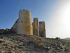 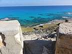    | |
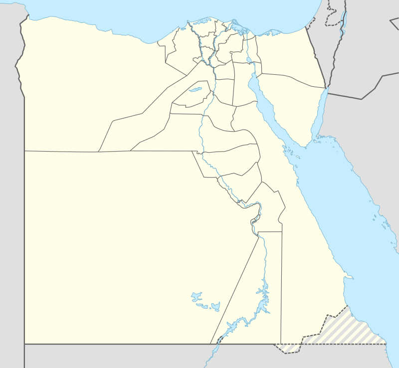 Marsa Matruh Location in Egypt | |
| Coordinates: 31°20′N 27°13′E | |
| Country | |
| Governorate | Matrouh |
| Elevation | 100 ft (30 m) |
| Population (2011) | |
| • City | 68,339 |
| • Metro | 140,000 |
| • Ethnicities | Egyptians, Bedouins & Egyptian-Libyans. |
| Time zone | UTC+2 (EST) |
| Area code(s) | (+20) 46 |
In ancient Egypt and during the reign of Alexander the Great, the city was known as Amunia. In the Ptolemaic Kingdom and later during the Byzantine Empire, it was known as Paraitónion (Koinē Greek: Παραιτόνιον). During the Roman Empire, it was called Paraetonium in Latin, which became Al-Baretoun (Arabic: البارتون) after the Arab conquest of Egypt.[1] As a British military base during World War II, several battles were fought around its environs as the German Afrika Korps attempted to capture the port. It fell to the Germans during the Battle of Mersa Matruh, but was recaptured following the Second Battle of El Alamein.
Marsa Matruh is served by Marsa Matruh International Airport. The city features soft white sand beaches and calm transparent waters; the bay is protected from the high seas by a series of rocks forming a natural breakwater, with a small opening to allow access for light vessels.
History
Mersa Matruh started as a small fishing town during Ancient Egyptian times and the reign of Alexander The Great and was named Amunia. There are ruins of a temple for Ramesses II (1200 BC). The city became known as Paraitonion in the Ptolemaic era. Ovid wrote that its goddess is Isis.[2] After Egypt came under Roman rule, the town became an important harbor for trade and shipping goods and crops to Rome.
After the Arabic conquest, the city's name changed to Al-Baretoun. The city also bore other names from at least the beginning of 20th century – Berek Marsa, Port Mhaddra (Mithr) and Port Bardiah.[3]
During World War II, the British Army's Baggush Box was located to the east. Starting with the completion of an extension from the previous railhead at Fuka in February 1936,[4] Marsa Matruh was the terminus for a single-track railway, which passed through El Alamein. Mersa Matruh served as a vital British military base during World War II and was a major objective of Erwin Rommel's Afrika Korps, which captured it during the Battle of Mersa Matruh.
Geography
Climate
Marsa Matruh has a hot desert climate (BWh) according to Köppen climate classification, but winds blowing from the Mediterranean Sea greatly moderate the temperature, making its summers moderately hot and humid while its winters mild and moderately wet. Summers are sunny and dry, while in the colder months, there is some rain and cloud cover. Sleet and hail are common in Winter.
Marsa Matruh and Port Said have the coolest summer days of all Egyptian cities and resorts, although not significantly cooler than other northern coastal places. Additionally Rafah, Alexandria, Abu Qir, Rosetta, Baltim, Kafr el-Dawwar and Marsa Matruh are the wettest in Egypt.
| Climate data for Marsa Matruh | |||||||||||||
|---|---|---|---|---|---|---|---|---|---|---|---|---|---|
| Month | Jan | Feb | Mar | Apr | May | Jun | Jul | Aug | Sep | Oct | Nov | Dec | Year |
| Record high °C (°F) | 31.0 (87.8) |
34.0 (93.2) |
40.0 (104.0) |
42.2 (108.0) |
42.4 (108.3) |
46.2 (115.2) |
44.2 (111.6) |
40.2 (104.4) |
43.8 (110.8) |
39.3 (102.7) |
34.4 (93.9) |
29.2 (84.6) |
46.2 (115.2) |
| Average high °C (°F) | 17.7 (63.9) |
18.5 (65.3) |
19.6 (67.3) |
22.9 (73.2) |
25.3 (77.5) |
28.1 (82.6) |
28.6 (83.5) |
29.5 (85.1) |
28.5 (83.3) |
26.5 (79.7) |
22.8 (73.0) |
19.3 (66.7) |
23.9 (75.0) |
| Daily mean °C (°F) | 12.9 (55.2) |
13.5 (56.3) |
15.1 (59.2) |
17.6 (63.7) |
20.2 (68.4) |
23.4 (74.1) |
25.0 (77.0) |
25.5 (77.9) |
24.3 (75.7) |
21.6 (70.9) |
17.9 (64.2) |
14.4 (57.9) |
19.3 (66.7) |
| Average low °C (°F) | 8.7 (47.7) |
8.9 (48.0) |
10.4 (50.7) |
12.5 (54.5) |
15.1 (59.2) |
18.6 (65.5) |
20.7 (69.3) |
21.2 (70.2) |
19.9 (67.8) |
17.2 (63.0) |
13.5 (56.3) |
10.4 (50.7) |
14.8 (58.6) |
| Record low °C (°F) | 1.0 (33.8) |
2.5 (36.5) |
1.0 (33.8) |
1.8 (35.2) |
7.2 (45.0) |
9.8 (49.6) |
11.6 (52.9) |
16.1 (61.0) |
10.0 (50.0) |
4.8 (40.6) |
6.0 (42.8) |
0.0 (32.0) |
0.0 (32.0) |
| Average precipitation mm (inches) | 36 (1.4) |
19 (0.7) |
11 (0.4) |
3 (0.1) |
2 (0.1) |
2 (0.1) |
0 (0) |
1 (0.0) |
1 (0.0) |
19 (0.7) |
18 (0.7) |
29 (1.1) |
141 (5.6) |
| Average precipitation days (≥ 1.0 mm) | 3.2 | 1.9 | 1.4 | 0.6 | 0.2 | 0.1 | 0.0 | 0.1 | 0.1 | 1.0 | 1.7 | 2.3 | 12.6 |
| Average relative humidity (%) | 71 | 69 | 68 | 66 | 73 | 73 | 75 | 73 | 71 | 70 | 68 | 69 | 70.5 |
| Mean monthly sunshine hours | 196.3 | 214.5 | 254.1 | 269.1 | 316.7 | 355.4 | 371.9 | 356.3 | 309.2 | 268.2 | 222.2 | 196.6 | 3,330.5 |
| Source 1: NOAA[5] | |||||||||||||
| Source 2: Voodoo Skies (record temperatures)[6] | |||||||||||||
Another source shows more precipitation and stabler average temperatures.
| Climate data for Marsa Matruh | |||||||||||||
|---|---|---|---|---|---|---|---|---|---|---|---|---|---|
| Month | Jan | Feb | Mar | Apr | May | Jun | Jul | Aug | Sep | Oct | Nov | Dec | Year |
| Average high °C (°F) | 17.9 (64.2) |
18.4 (65.1) |
20.2 (68.4) |
22.5 (72.5) |
24.1 (75.4) |
26.9 (80.4) |
27.9 (82.2) |
28.4 (83.1) |
28.5 (83.3) |
26.9 (80.4) |
24.0 (75.2) |
20.2 (68.4) |
23.8 (74.9) |
| Daily mean °C (°F) | 13.1 (55.6) |
13.6 (56.5) |
15.4 (59.7) |
17.9 (64.2) |
20.0 (68.0) |
23.1 (73.6) |
24.8 (76.6) |
25.3 (77.5) |
24.8 (76.6) |
22.5 (72.5) |
19.2 (66.6) |
15.4 (59.7) |
19.6 (67.3) |
| Average low °C (°F) | 8.4 (47.1) |
8.9 (48.0) |
10.6 (51.1) |
13.3 (55.9) |
16.0 (60.8) |
19.4 (66.9) |
21.8 (71.2) |
22.3 (72.1) |
21.1 (70.0) |
18.2 (64.8) |
14.4 (57.9) |
10.6 (51.1) |
15.4 (59.7) |
| Average precipitation mm (inches) | 38 (1.5) |
23 (0.9) |
12 (0.5) |
2 (0.1) |
2 (0.1) |
1 (0.0) |
0 (0) |
1 (0.0) |
2 (0.1) |
14 (0.6) |
23 (0.9) |
34 (1.3) |
152 (6) |
| Source: Climate-Data.org[7] | |||||||||||||
| Jan | Feb | Mar | Apr | May | Jun | Jul | Aug | Sep | Oct | Nov | Dec |
|---|---|---|---|---|---|---|---|---|---|---|---|
| 18 °C (64 °F) | 17 °C (63 °F) | 17 °C (63 °F) | 18 °C (64 °F) | 20 °C (68 °F) | 23 °C (73 °F) | 25 °C (77 °F) | 26 °C (79 °F) | 26 °C (79 °F) | 25 °C (77 °F) | 22 °C (72 °F) | 20 °C (68 °F) |
Main sights
- Ruins of the Temple of the King, Pharaoh Ramesses II (1200 BC)
- Drowned city of Caesar.
- Drowned Palace of Cleopatra.
- Egyptian Fleet Anchorage which was built by the Ptolemies. The remains of the naval installations still stand west of the port.
- Coptic Chapel: built in the early Coptic age, it contains several caves bearing inscriptions.
- Rommel's Hideout: A cave, hewn in the rock, where Rommel drew up plans of his military operations. It has now been turned into a military museum.
- The British Cemetery: Thousands of rock-hewn tombstones stand in straight rows amidst a fenced garden.
- The German Cemetery: It is a fortress like memorial that was built on a height overlooking the sea.
- The Italian Cemetery: It is a high tower fort standing on a high hill. The walls of the building are covered with marble.
Main beaches
- Ageebah Beach: About 28 km west of Marsa Matruh downtown, it is distinguished by its numerous natural cave
- Al-Obayed Beach: About 20 km west of Marsa Matruh downtown
- Rommel Bay.
References
| Wikimedia Commons has media related to Mersa Matruh. |
- "CATHOLIC ENCYCLOPEDIA: Paraetonium". catholicencyclopedia.newadvent.com. Retrieved 2019-01-15.
- "ToposText". topostext.org. Retrieved 2019-12-30.
- Raza, Moonis (1990). Geographical Dictionary Of The World In The Early 20th Century With Pronouncing Gazetteer (in 2 Vos.). Concept Publishing Company. ISBN 978-81-7268-011-4.
- Playfair, Vol. I, page 3.
- "Marsa Matruh A Climate Normals 1961–1990". National Oceanic and Atmospheric Administration. Retrieved April 5, 2015.
- "Mersa Matruh Monthly Temperature weather history". Voodoo Skies. Retrieved 18 August 2015.
- "Climate: Marsa Matruh - Climate graph, Temperature graph, Climate table". Climate-Data.org. Retrieved 17 August 2013.
- "Marsa Matruh Climate and Weather Averages, Egypt". Weather to Travel. Retrieved 13 July 2013.
- Falling Rain Genomics, Inc. "Geographical information on Marsa Matruh, Egypt". Retrieved 2008-03-23.
External links
Sources
- Playfair, Major-General I.S.O.; Molony, Brigadier C.J.C.; with Flynn, Captain F.C. (R.N.) & Gleave, Group Captain T.P. (2009) [1st. pub. HMSO:1954]. Butler, Sir James (ed.). The Mediterranean and Middle East, Volume I: The Early Successes Against Italy, to May 1941. History of the Second World War, United Kingdom Military Series. Uckfield, UK: Naval & Military Press. ISBN 1-84574-065-3.
| Authority control |
|
|---|
| 1,000,000 and more | |
|---|---|
| 300,000–999,999 | |
| 100,000–299,999 | |
| <99,999 | |