Talkha
Talkha (Arabic: طلخا pronounced [ˈtˤɑlxɑ]) is a city in Dakahlia Governorate, Egypt. The city is located on the west bank of the Damietta,[1] a distributary of the Nile in the Delta region. Is about 120 km northeast of Cairo. Talkha is situated opposite the city of Mansoura on the Damietta. Together, the two cities form an agglomeration.
Talkha | |
|---|---|
city | |
 Talkha (right) and Mansoura (left) | |
 Talkha Location in Egypt | |
| Coordinates: 31.054735°N 31.375644°E | |
| Country | |
| Governorate | Dakahlia |
| Elevation | 18 m (59 ft) |
| Population (2012) | |
| • Total | 92,084 |
| Time zone | UTC+2 (EET) |
| Postal code | 35111 |
| Area code(s) | 50 |
Talkha contains the neighborhoods of Old Market, El Maalamein, Ar Rouda, El Sharifa, and El Muhandisin.
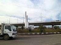
Roads in Talkha
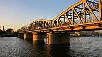
Railway bridge between Talkha and Mansoura
Climate
Talkha is classified within the Köppen-Geiger climate classification system as a hot desert (BWh).
| Climate data for Talkha | |||||||||||||
|---|---|---|---|---|---|---|---|---|---|---|---|---|---|
| Month | Jan | Feb | Mar | Apr | May | Jun | Jul | Aug | Sep | Oct | Nov | Dec | Year |
| Average high °C (°F) | 18.9 (66.0) |
19.8 (67.6) |
22.4 (72.3) |
26.3 (79.3) |
32 (90) |
33 (91) |
32.7 (90.9) |
33.3 (91.9) |
32 (90) |
27.5 (81.5) |
25 (77) |
20.6 (69.1) |
27.0 (80.6) |
| Daily mean °C (°F) | 12.8 (55.0) |
13.5 (56.3) |
15.8 (60.4) |
19.1 (66.4) |
23.6 (74.5) |
25.7 (78.3) |
26.7 (80.1) |
26.9 (80.4) |
25.3 (77.5) |
22.8 (73.0) |
19.4 (66.9) |
14.8 (58.6) |
20.5 (69.0) |
| Average low °C (°F) | 6.8 (44.2) |
7.3 (45.1) |
9.2 (48.6) |
11.9 (53.4) |
15.2 (59.4) |
18.4 (65.1) |
20.7 (69.3) |
20.5 (68.9) |
18.7 (65.7) |
17 (63) |
13.9 (57.0) |
9.1 (48.4) |
14.1 (57.3) |
| Average precipitation mm (inches) | 13 (0.5) |
9 (0.4) |
6 (0.2) |
4 (0.2) |
3 (0.1) |
0 (0) |
0 (0) |
0 (0) |
0 (0) |
4 (0.2) |
7 (0.3) |
11 (0.4) |
57 (2.3) |
| Source: Climate-Data.org[2] | |||||||||||||
See also
References
- "Map of Talkha". Dakahliya Governorate site.
- "Climate: Talkha - Climate graph, Temperature graph, Climate table". Climate-Data.org. Archived from the original on 2015-02-24. Retrieved 13 August 2013.
| 1,000,000 and more | |
|---|---|
| 300,000–999,999 | |
| 100,000–299,999 | |
| <99,999 | |
This article is issued from Wikipedia. The text is licensed under Creative Commons - Attribution - Sharealike. Additional terms may apply for the media files.