Nimruz Province
Nimruz or Nimroz (Dari/Persian: ولایت نیمروز; Pashto: نيمروز ولايت) is one of the 34 provinces of Afghanistan, located in the southwestern part of the country. It lays to the east of the Sistan and Baluchestan Province of Iran and north of Balochistan, Pakistan, also bordering the Afghan provinces of Farah and Helmand. The province contains five districts, encompassing about 649 villages, and roughly 156,600 settled people,[1] the second least populous province. The city of Zaranj serves as the provincial capital and Zaranj Airport, which is located by that city, serves as a domestic airport for the province.
Nimruz نيمروز | |
|---|---|
 Chakhansur in Nimruz Province | |
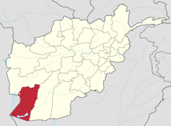 Map of Afghanistan with Nimruz highlighted | |
| Coordinates (Capital): 31.0°N 62.5°E | |
| Country | |
| Capital | Zaranj |
| Government | |
| • Governor | Muhammad Samiullah |
| Area | |
| • Total | 41,356 km2 (15,968 sq mi) |
| Population (2012)[1] | |
| • Total | 156,600 |
| • Density | 3.8/km2 (9.8/sq mi) |
| Time zone | UTC+4:30 (Afghanistan Time) |
| ISO 3166 code | AF-NIM |
| Main languages | Dari Pashto Balochi |
The name Nimruz means "mid-day" or "half-day" in Persian. The name is believed to indicate that the meridian cutting the old world in half passes through this region. Nimruz covers 41,000 km². It is the most sparsely populated province in the country,[2] located in the Sistan Basin. A substantial part of the province is the barren desert area of Dashti Margo.
History
The area now composing Nimruz province of Afghanistan was once part of the historical region of Sistan, which over the many centuries was held by the Achaemenid Empire, Alexander the Great and others before being conquered and converted to Islam by the Muslim Arabs in the 7th century. The region became part of the Saffarid dynasty in 860 CE with its capital at Zaranj, which was one of the first local dynasties of the Islamic era. Its founder Yaqub Saffari was born and raised in this region. The territory became part of the Ghaznavids followed by the Ghurids, Timurids, and Safavids.
In the early 18th century, the region fell to the Afghan Hotaki dynasty until they were removed from power in 1738 by Nader Shah. By 1747, Ahmad Shah Durrani made it part of Afghanistan after he conquered the territory from northeastern Iran to Delhi in India. Under the modern Afghan governments, the province was known as Chakhansur Province until 1968, when it was separated to form the provinces of Nimruz and Farah.[3] The city of Zaranj became the capital of Nimroz province at that time. During the Soviet–Afghan War, Nimruz province was used by mujahideen crossing back and forth between Afghanistan and neighboring countries. It was also used by Afghan refugees escaping the war as well as by smugglers.
As the Taliban came to power in 1995, they seized the road-controlling town of Delaram (now within Farah Province), and came to an agreement with the mujahideen warlords holding Nimroz that the fate of the province would not be decided until a clear victor emerged in the capture of Kabul. However, the Taliban advanced on Nimruz only days later, and the mujahideen under command of Abdul Karim Brahui fled to Iran.
NATO presence and the Karzai administration
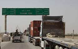
Following US-led invasion in October 2001, the Taliban began losing control of the province to the new Afghan government under President Hamid Karzai.[4] The area is historically known for drugs and weapons smuggling between Afghanistan, Iran and Pakistan. Many foreign militants also use the province to go back and forth between the 3 nations. The Delaram–Zaranj Highway was built by the Indian government in 2009, which is one of the main trade route of the country and is expected to boost the socio economic development in the province.
Since 2002, members of the U.S. Marine Corps were present in the province. When the International Security Assistance Force (ISAF) arrived to Kandahar, Nimruz province became part of the Regional Command Southwest. The local Afghan National Security Forces (ANSF) are being trained by these forces. ISAF is also involved in development activities.
Politics and governance
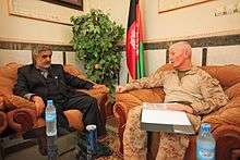
The current governor is Mohammad Samiullah.[5][6] His predecessor was Amir Muhammad Akhundzada. All law enforcement activities throughout the province are managed by the Afghan National Police (ANP). The borders with neighboring Iran and Pakistan are monitored by the Afghan Border Police (ABP). A provincial police chief is assigned to lead both the ANP and the ABP. The Police Chief represents the Ministry of the Interior in Kabull. The ANP and ABP are backed by the military, including the NATO-led forces.
Healthcare
The percentage of households with clean drinking water fell from 38% in 2005 to 24% in 2011.[7] The percentage of births attended to by a skilled birth attendant increased from 7% in 2005 to 28% in 2011.[7]
Education
The overall literacy rate (6+ years of age) increased from 22% in 2005 to 23% in 2011.[7] The overall net enrolment rate (6–13 years of age) increased from 33% in 2005 to 49% in 2011.[7]
Transport and economy
As of June 2014 Zaranj Airport which is located near the city of Zaranj had regularly scheduled flights to Herat.
The Delaram–Zaranj Highway has been constructed by India via Chaknasur, which is expected to boost the socio economic development in the region.
Trade and farming is the main source of income for the majority. This includes agriculture and animal husbandry. Animals include sheep, goat, cattle, and poultry. The province produces the following: Wheat, corn, melons, poppies; almost all irrigated.[8]
Nimruz's isolation has led to one author in 2010 calling it Afghanistan's "forgotten province." However, it is a major international smuggling hub due to its border with Iran. Locally there is a large Iranian influence, including the products on the local market.[9]
Geography
The Sistan Basin dominates the province. Many parts of the south are covered by the Godzareh depression which includes marshes and dry lakes.[10]
Demography
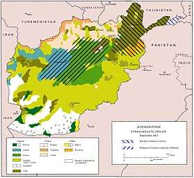

The population of Nimruz Province is approximately 156,600 settled people.[1] There are also many Kuchi nomads who inhabit the province seasonally. It is the only province of Afghanistan where the Baloch ethnic group forms a majority.[9] The Balochs are followed by Pashtun, Brahui, Tajik, Uzbek, and Hazara. The Pashtun tribes are mostly Barakzai and Nurzai. Almost all inhabitants except Hazaras follow Sunni Islam.[8] Languages spoken in the province are Balochi, which is spoken by the Baloch Nation as their mother tongue, as well as Dari and Pashto.
Population by districts
| District | Capital | Population[11] | Area | Number of villages and ethnic groups |
|---|---|---|---|---|
| Chahar Burjak | 8,080 | 21,864 km2 | 65 villages. 88% Baloch, 10% Brahawi, 1% Pashtun, and 1% Tajik.[12] | |
| Chakhansur | Chakhansur | 11,165 | 9,699 km2 | 160 villages. Pashtun, Tajik, Baloch and Hazara.[13] |
| Kang | 13,514 | 1,250 km2 | 119 villages. 60% Pashtun, 25% Baloch, 15% Tajik.[14] | |
| Khash Rod | Khash | 35,381 | 5,766 km2 | 63 villages. 55% Pashtun, 20% Baluch, 15% Brahawi, 10% Tajik.[15] |
| Zaranj | Zaranj | 49,851 | 755 km2 | 242 villages. 44% Baloch, 34% Pashtun, and 22% Tajik.[16] |
See also
References
- "Settled Population of Nimroz province by Civil Division, Urban, Rural and Sex-2012-13" (PDF). Islamic Republic of Afghanistan: Central Statistics Organization. Retrieved 2012-10-31.
- https://communitypolicing.eu/2016/03/30/soldiers-or-police/
- Frank Clements. Conflict in Afghanistan: A Historical Encyclopedia. ABC-CLIO, 2003. ISBN 1-85109-402-4, ISBN 978-1-85109-402-8. Pg 181
- Robert D. Crews, Amin Tarzi. The Taliban and the crisis of Afghanistan. Harvard University Press, 2008. ISBN 0-674-02690-X, 9780674026902. Pg 185-187
- http://www.pajhwok.com/en/2015/05/31/new-nimroz-governor-vows-eradicate-graft
- http://www.afghan-web.com/politics/governors.html
- Archive, Civil Military Fusion Centre, https://www.cimicweb.org/AfghanistanProvincialMap/Pages/Nimroz.aspx
- "Nimroz" (PDF). Program for Culture & Conflict Studies. Naval Postgraduate School. Retrieved 2012-12-28.
- https://thediplomat.com/2010/12/afghanistans-forgotten-province/
- https://www.awm.gov.au/collection/LIB100035066
- "Nimrooz Province". Government of Afghanistan and United Nations Development Programme (UNDP). Ministry of Rural Rehabilitation and Development. Retrieved 2012-10-31.
- Charborjak District Archived 2013-07-28 at the Wayback Machine
- Chakhansor District Archived 2015-12-22 at the Wayback Machine
- Kang District Archived 2014-04-07 at the Wayback Machine
- Khashrod District
- Zaranj District
External links
| Wikimedia Commons has media related to Nimroz Province. |
Places adjacent to Nimruz Province | ||||||||||
|---|---|---|---|---|---|---|---|---|---|---|
| ||||||||||
| Authority control |
|
|---|