Farah Province
Farah (Pashto/Dari: (فرا) is one of the 34 provinces of Afghanistan, located in the western part of the country next to Iran. It is a spacious and sparsely populated province, divided into eleven districts and contains hundreds of villages. It has a population of about 925,016,[2] which is multi-ethnic and mostly a rural tribal society. The Farah Airport is located near the city of Farah, which serves as the capital of the province. Farah is linked with Iran via the Iranian border town of Mahirud.
Farah فرا | |
|---|---|
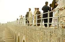
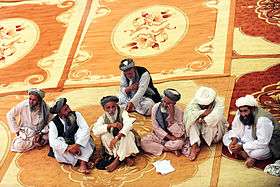
 ISAF forces pull security for the safety of the pilots and team of an Mil Mi-17 helicopter as it leaves the Gulistan district in 2009. | |
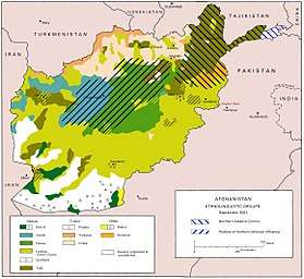
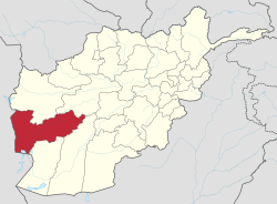 Map of Afghanistan with Farah highlighted | |
| Coordinates (Capital): 32.5°N 63.5°E | |
| Country | |
| Capital | Farah |
| Government | |
| • Governor | Mohammad Asif Shah Jahan |
| Area | |
| • Total | 48,470.9 km2 (18,714.7 sq mi) |
| Population (2015)[1] | |
| • Total | 925,016 |
| • Density | 19/km2 (49/sq mi) |
| Time zone | UTC+4:30 (Afghanistan Time) |
| ISO 3166 code | AF-FRA |
| Main languages | Pashto Dari |
Geographically the province is approximately 48,000 square kilometres (19,000 sq mi), making it (comparatively) more than twice the size of Maryland, or half the size of South Korea. The province is bounded on the north by Herat, on the northeast by Ghor, the southeast by Helmand, the south by Nimroz, and on the west by Iran. It is the fourth largest province in Afghanistan by area size, but the second least densely populated province.
History
Shahr-e Kohn-e ("Old City") or Fereydun Shahr ("City of Fereydoon") is located in Farah city. This ancient city is more than 3000 years old. It was one of the ancient places of the Persian kings, as Farah belonged historically to the Sistan empire. The name "Fereydun" here refers to a hero of the Persian epic Shahnameh.
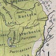
The territory was known around 500 BC as Drangiana, with Arachosia being to the east and Ariana to the north. It was part of the Median Empire followed by the Achaemenids. In 330 BC Alexander the Great took possession of the land and made it part of his empire. Upon Alexander's untimely death in 323 BC the region, along with the rest of his vast empire, was fought over by his generals all vying to be his successor. Eventually several of these were successful in carving out parts of Alexander's empire for themselves thereby becoming his official successors or Diadochi. One of these generals, Seleucus, made this region part of his domain giving it his name as the Seleucid Empire. They were replaced by other rulers and the area eventually fell to the Sassanids, then to the Arab Muslims. The Saffarids rose to power in 867 AD in Zaranj and made Farah part of their empire. By the 10th century the province became part of the Ghaznavid Empire, whose capital was located in Ghazni. They were replaced by the Ghurids and then after a century later the area saw the Mongol invasion.
The province was taken by Timur and eventually fell to the Safavid dynasty. It had been lost by the Safavids to the Uzbeks of Transoxiana, but was regained following a Safavid counter-offensive around 1600 CE, along with Herat and Sabzavar.[3] In 1709, the Afghans gained independence from the Safavids and Farah became part of the Hotaki Empire. By 1747, it became part of Ahmad Shah Durrani's last Afghan empire. During the 19th century, the British army passed through the province to support Afghan forces in Herat Province against the invading Persians.
Following the Marxist revolution in 1978, Farah was one of the cities in which civilian massacres were carried out by the now-dominant Khalqi communists against their political, ethnic, and religious opponents.[4]:97 At the start of the 1980s, the majority of Farah was allied with the Harakat-i-Inqilab-i-Islami movement, but after 1981 the province split along linguistic lines, with Pashtun-speaking opponents of the communist government remaining with Harakat, Group-e-Malema (Teacher Group) and Tajiks moving to the Jamiat-e Islami.[4]
Following the 1992 collapse of the communist-backed Democratic Republic of Afghanistan, Farah Province, unlike many other provinces was relatively peaceful. Most of the Farah Mujahideen belonged to Harakat Islami of Malavi Khalas, Group-e-Malema (Teacher Group), Hizb-e-Islami and Jamiat Islami.
A 1995 Oxfam report lists Farah as "severely mined", and indicated that Farah was particularly problematic due to the wide variety of mine devices employed there, as well as usage of mines to deny access to irrigation systems.[5] By late 1995, the stalemate broke as the Taliban counterattacked after Ismail Khan's failed drive to Kandahar, and all of Farah fell as the Taliban swept to take Herat on 5 September 1995.[6]
Recent history

Due to its isolation from the Taliban's area of focus, Farah exerted some small level of local control during Taliban rule. By the end of the Taliban period, there were eight United Nations Development Program (UNDP) schools, for both boys and girls, recognized and supported by the Taliban in Kandahar and Farah. UNDP noted that the local authorities in Farah were "particularly cooperative" on the subject.[7]
Following the Coalition entry and union with the Northern Alliance after September 11, 2001, the Taliban withdrew from Farah due to the heavy Coalition aerial campaign, though ground troops were not sent to the province until some time later.[8][9]
Farah has witnessed heavy clashes since the US backed overthrow of the Taliban in 2001, and is being considered insecure , relative to many parts of the country. Although there has been sporadic heavy combat in the Bala Baluk, Bakwa, Khak-e-Safid, Pusht-e-Road and Gulestan districts. Due to its proximity to the restive Helmand and Uruzgan provinces, Farah has experienced problems with roaming insurgent gangs moving through the province and occupying parts of the province for brief periods of time. Incidents of this type have increased as Taliban fighters face heavy pressure from the International Security Assistance Force (ISAF) offensives in the south.
The roads in Farah province have seen massive improvement since May 2005 and are still being improved to date April 2006. The education system has been greatly improved and a great number of illegal weapons have been collected and destroyed in the province as testimony to the Provincial Reconstruction Team. The United States built a base at Farah Airport, which is being expanded and also houses the Afghan National Security Forces (ANFS).
In May 2009, an American airstrike in the village of Granai in Bala Buluk District occurred that killed a large number of civilians. According to The New York Times, the villagers said that 147 were killed, an independent Afghan human rights group put the number of killed at 117. The Americans claimed the airstrike was targeting Taliban militants, but villagers said that the Taliban had left by the time the airstrike occurred.[10] On May 19, the U.S. Ambassador to Afghanistan Karl Eikenberry visited Farah town to talk with the survivors. He promised that "the United States will work tirelessly with your government, army and police to find ways to reduce the price paid by civilians, and avoid tragedies like what occurred in Bala Baluk."[11]
Demographics
The total population of Farah province is about 925,016,[12] which is predominately tribal and a rural society. About 482,400 are settled[2] while the remaining are the Kuchi and other nomads. More than 80% of the province consists of ethnic Pashtuns (excluding Kochi nomads) followed by Tajiks (14%) as second largest group residing mainly in Farah city and Balochis as third group. The primary Pashtun tribes in Farah province are the Alizai, Barakzai, and Nurzai.[13] However, the Kochi nomads, a Pashtun group, make a sizeable population in winter.[14]
The provincial dominant language is Pashto and Dari (Afghan Persian). Pashto is spoken by around 60%, while around 30% speak Dari.[13]
Districts
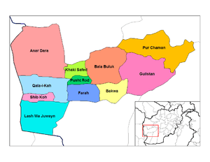
| District | Capital | Population[15] | Area | Number of villages and ethnic groups |
|---|---|---|---|---|
| Anar Dara | 65,573 | 5,000 km2 | 50 villages. 70% Tajiks, 30% Pashtuns.[16] | |
| Bakwa | 39,871 | 2,424 km2 | 80 villages. 100% Pashtuns.[17] | |
| Bala Buluk | 100,429 | km2 | 95% Pashtuns, 5% Tajiks.[18] | |
| Farah | Farah | 104,300 | 3,500 km2 | 115 villages. 80% Pashtuns, 20% Tajiks.[19] |
| Gulistan | 49,774 | 7,102 km2 | 109 villages. 90% Pashtuns, 10% Tajiks.[20] | |
| Khaki Safed | 37,000 | 1,200 km2 | 60 villages. 100% Pashtuns.[21] | |
| Lash Wa Juwayn | 27,100 | 5,491 km2 | 63 villages. 50% Pashtuns, 50% Tajiks.[22] | |
| Pur Chaman | 51,626 | 6,694 km2 | 294 villages. 70% Tajiks, 30% Pashtuns.[23] | |
| Pusht Rod | 39,500 | 1,200 km2 | 60 villages. 100% Pashtuns.[24] | |
| Qala-I-Kah | 30,653 | 3,598 km2 | 56 villages. 50% Pashtuns, 50% Tajiks.[25] | |
| Shib Koh | 23,013 | 2,738 km2 | 56 villages. 70% Pashtuns, 30% Tajiks[26] |
Politics and governance
The current governor of the province is Doctor Muhammad Shah Jahan Arif who replaced Mohammad Asif Nang. All law enforcement activities throughout the province are managed by the Afghan National Police (ANP). The border with neighboring Iran is monitored by the Afghan Border Police (ABP). A provincial police chief is assigned to lead both the ANP and the ABP. The Police Chief represents the Ministry of the Interior in Kabull. The ANP and ABP are backed by the military, including the NATO-led forces.
Religious sites

The tomb of Muhammad Jaunpuri is believed to be in Farah.
Economy
Farah's economy is overwhelmingly agricultural. The province has minerals such as gypsum, lime and construction stones, uranium ore,[27] and copper.[28] More than 1300 workers are employed by 15 manufacturing firms in the province.[27] 74% of rural households reported either agriculture or livestock to be their main source of income and 24% reported that trade and service (including non-farm labor) to their main source of income.[29]
Transportation
The Farah Airport is located next to the city of Farah and as of May 2014 had regularly scheduled flights to Herat.
The major road is Route 515 which connects Farah to the Ring Road between Herat and Kandahar. Both roads were improved in 2009 in coordination with several ISAF countries.
Healthcare
The percentage of households with clean drinking water increased from 3% in 2005 to 14% in 2011.[30] 6% of births were attended to by a skilled birth attendant in 2011.[30]
Education
The overall literacy rate (6+ years of age) fell from 28% in 2005 to 18% in 2011.[30] The overall net enrollment rate (6–13 years of age) increased from 50% in 2005 to 68% in 2011.[30]
Further reading
- Words in the Dust (fiction), by author Trent Reedy who was one of the first American soldiers to enter Farah in 2004. Link
References
- Afghanistan at GeoHive
- "Settled Population of Farah province by Civil Division, Urban, Rural and Sex-2012-13" (PDF). Islamic Republic of Afghanistan, Central Statistics Organization. Retrieved 2012-10-22.
- William Bayne Fisher. The Cambridge history of Iran. Cambridge University Press, 1986. ISBN 0-521-20094-6, ISBN 978-0-521-20094-3
- Olivier Roy. Islam and resistance in Afghanistan. Cambridge University Press, 1990. ISBN 0-521-39700-6, ISBN 978-0-521-39700-1
- Shawn Roberts, Jody Williams. After the guns fall silent: the enduring legacy of landmines. Oxfam, 1995. ISBN 0-85598-337-X, 9780855983376
- Peter Marsden. The Taliban: war, religion and the new order in Afghanistan. Palgrave Macmillan, 1998. ISBN 1-85649-522-1, ISBN 978-1-85649-522-6
- Susan Hawthorne, Bronwyn Winter. September 11, 2001: feminist perspectives. Spinifex Press, 2002. ISBN 1-876756-27-6, ISBN 978-1-876756-27-7
- Malalai Joya. A Woman Among Warlords: The Extraordinary Story of an Afghan Who Dared to Raise Her Voice. Simon and Schuster, 2009. ISBN 1-4391-0946-X, 9781439109465
- Harvey Langholtz, Boris Kondoch, Alan Wells. International Peacekeeping: The Yearbook of International Peace Operations. Martinus Nijhoff Publishers, 2003. ISBN 90-411-2191-9, ISBN 978-90-411-2191-2
- Carlotta Grall; Taimoor Shah (May 14, 2009). "Afghan Villagers Describe Chaos of U.S. Strikes". The New York Times.
- Carlotta Grall (May 19, 2009). "A Vow to Cut Afghan Civilian Deaths". The New York Times.
- "Province: Farah" (PDF). Program for Culture & Conflict Studies. Naval Postgraduate School (NPS). February 3, 2009. Archived from the original (PDF) on 2013-10-16. Retrieved 2013-01-13.
- "Farah Provincial Overview". Program for Conflict and Culture Studies. Naval Postgraduate School (NPS). Retrieved 2013-01-13.
- "Provincial Development Plan, Farah Provincial Profile" (PDF). Afghanistan Ministry of Rural Rehabilitation and Development and the United Nations Development Programme (UNDP). Archived from the original (PDF) on 2 December 2010.
- "Farah Province". National Area-Based Development Programme (NABDP). Ministry of Rural Rehabilitation and Development. Archived from the original on 2013-04-14. Retrieved 2013-01-13.CS1 maint: unfit url (link)
- Anar Dara District (Re-elected)
- Bakwa District
- "District Profile" (PDF). UNHCR. Archived from the original (PDF) on 27 October 2005. Retrieved 6 June 2006.
- Farah Center (Re-elected)
- Gulistan District
- Khaki Safid District (Re-elected)
- Lash Wa Jowain District
- Purchaman District
- Poshti Rod District (Re-elected)
- Qalae Kah (Poshti Koh) District
- Sheb Koh District
- "National Area-Based Development Programme, Farah Provincial Profile" (PDF). Archived from the original on 2016-03-03. Retrieved 2015-09-15.CS1 maint: unfit url (link)
- Bada, Ferdinand (2019-04-15). "Natural Resources Of Afghanistan". WorldAtlas. Retrieved 2019-09-30.
Historically, copper exists in Afghan provinces such as Herat, Farah, Kandahar, Kapisa, and Zabul.
- WFP, http://www.foodsecurityatlas.org/afg/country/provincial-Profile/Farah Archived 2014-03-14 at the Wayback Machine
- "DAI KUNDI PROVINCE". Civil-Military Fusion Centre Archive. Archived from the original on 2014-05-31.
External links
| Wikimedia Commons has media related to Farah Province. |
Places adjacent to Farah Province | |
|---|---|