National Register of Historic Places listings in Osceola County, Florida
This is a list of the National Register of Historic Places listings in Osceola County, Florida.
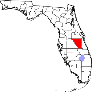
Location of Osceola County in Florida
This is intended to be a complete list of the properties and districts on the National Register of Historic Places in Osceola County, Florida, United States. The locations of National Register properties and districts for which the latitude and longitude coordinates are included below, may be seen in a map.[1]
There are 9 properties and districts listed on the National Register in the county.
- This National Park Service list is complete through NPS recent listings posted June 19, 2020.[2]
| Alachua - Baker - Bay - Bradford - Brevard - Broward - Calhoun - Charlotte - Citrus - Clay - Collier - Columbia - DeSoto - Dixie - Duval - Escambia - Flagler - Franklin - Gadsden - Gilchrist - Glades - Gulf - Hamilton - Hardee - Hendry - Hernando - Highlands - Hillsborough (Tampa) - Holmes - Indian River - Jackson - Jefferson - Lafayette - Lake - Lee - Leon - Levy - Liberty - Madison - Manatee - Marion - Martin - Miami-Dade (Miami) - Monroe - Nassau - Okaloosa - Okeechobee - Orange - Osceola - Palm Beach - Pasco - Pinellas - Polk - Putnam - St. Johns - St. Lucie - Santa Rosa - Sarasota - Seminole - Sumter - Suwannee - Taylor - Union - Volusia - Wakulla - Walton - Washington |
Current listings
| [3] | Name on the Register[4] | Image | Date listed[5] | Location | City or town | Description |
|---|---|---|---|---|---|---|
| 1 | Colonial Estate |  Colonial Estate |
January 3, 1994 (#93001455) |
2450 Old Dixie Highway 28°18′59″N 81°24′13″W |
Kissimmee | Part of the Kissimmee MPS |
| 2 | Desert Inn |  Desert Inn |
January 3, 1994 (#93001158) |
5570 South Kenansville Road 27°42′00″N 80°54′18″W |
Yeehaw Junction | |
| 3 | First United Methodist Church |  First United Methodist Church |
January 3, 1994 (#93001457) |
215 East Church Street 28°17′22″N 81°24′24″W |
Kissimmee | Part of the Kissimmee MPS |
| 4 | Grand Army of the Republic Memorial Hall |  Grand Army of the Republic Memorial Hall |
February 21, 1997 (#97000097) |
1101 Massachusetts Avenue 28°14′51″N 81°17′05″W |
St. Cloud | |
| 5 | Kissimmee Historic District |  Kissimmee Historic District |
January 4, 1994 (#93001454) |
Roughly bounded by Aultman Street, Monument Avenue, Penfield Street, and Randolph Avenue 28°17′31″N 81°24′40″W |
Kissimmee | Part of the Kissimmee MPS |
| 6 | Monument of States | 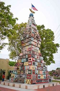 Monument of States |
December 8, 2015 (#15000862) |
East Monument Avenue & Lakeview Drive 28°17′30″N 81°24′17″W |
Kissimmee | |
| 7 | Old Holy Redeemer Catholic Church | 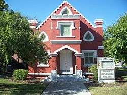 Old Holy Redeemer Catholic Church |
January 3, 1994 (#93001456) |
120 North Spoule Avenue 28°17′45″N 81°24′24″W |
Kissimmee | Part of the Kissimmee MPS |
| 8 | Osceola County Courthouse | 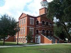 Osceola County Courthouse |
August 16, 1977 (#77000406) |
Bounded by Emmett, Bryan, Rose, and Vernon Streets 28°17′28″N 81°24′42″W |
Kissimmee | |
| 9 | St. Cloud Depot |  St. Cloud Depot |
July 31, 2018 (#100002728) |
915 New York Avenue 28°14′57″N 81°17′01″W |
St. Cloud |
See also
| Wikimedia Commons has media related to National Register of Historic Places in Osceola County, Florida. |
References
- The latitude and longitude information provided in this table was derived originally from the National Register Information System, which has been found to be fairly accurate for about 99% of listings. Some locations in this table may have been corrected to current GPS standards.
- "National Register of Historic Places: Weekly List Actions". National Park Service, United States Department of the Interior. Retrieved on June 19, 2020.
- Numbers represent an ordering by significant words. Various colorings, defined here, differentiate National Historic Landmarks and historic districts from other NRHP buildings, structures, sites or objects.
- "National Register Information System". National Register of Historic Places. National Park Service. March 13, 2009.
- The eight-digit number below each date is the number assigned to each location in the National Register Information System database, which can be viewed by clicking the number.
Municipalities and communities of Osceola County, Florida, United States | ||
|---|---|---|
| Cities | | |
| CDPs | ||
| Unincorporated communities |
| |
| Ghost town | ||
| Footnotes | ‡This populated place also has portions in an adjacent county or counties | |
This article is issued from Wikipedia. The text is licensed under Creative Commons - Attribution - Sharealike. Additional terms may apply for the media files.