National Register of Historic Places listings in Martin County, Florida
This is a list of the National Register of Historic Places listings in Martin County, Florida.
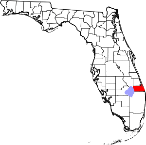
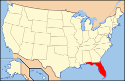
Location of Martin County in Florida
This is intended to be a complete list of the properties and districts on the National Register of Historic Places in Martin County, Florida, United States. The locations of National Register properties and districts for which the latitude and longitude coordinates are included below, may be seen in a map.[1]
There are 14 properties and districts listed on the National Register in the county.
- This National Park Service list is complete through NPS recent listings posted June 19, 2020.[2]
| Alachua - Baker - Bay - Bradford - Brevard - Broward - Calhoun - Charlotte - Citrus - Clay - Collier - Columbia - DeSoto - Dixie - Duval - Escambia - Flagler - Franklin - Gadsden - Gilchrist - Glades - Gulf - Hamilton - Hardee - Hendry - Hernando - Highlands - Hillsborough (Tampa) - Holmes - Indian River - Jackson - Jefferson - Lafayette - Lake - Lee - Leon - Levy - Liberty - Madison - Manatee - Marion - Martin - Miami-Dade (Miami) - Monroe - Nassau - Okaloosa - Okeechobee - Orange - Osceola - Palm Beach - Pasco - Pinellas - Polk - Putnam - St. Johns - St. Lucie - Santa Rosa - Sarasota - Seminole - Sumter - Suwannee - Taylor - Union - Volusia - Wakulla - Walton - Washington |
Current listings
| [3] | Name on the Register[4] | Image | Date listed[5] | Location | City or town | Description |
|---|---|---|---|---|---|---|
| 1 | Burn Brae Plantation-Krueger House |  Burn Brae Plantation-Krueger House |
February 14, 2002 (#02000002) |
1170 Southeast Ocean Boulevard 27°11′47″N 80°13′56″W |
Stuart | NRHP# 02000002 |
| 2 | Cypress Lodge | 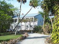 Cypress Lodge |
November 12, 2008 (#08001040) |
18681 SW Conners Highway 26°58′29″N 80°36′48″W |
Port Mayaca | NRHP# 08001040 |
| 3 | Gate House |  Gate House |
November 21, 2001 (#01001246) |
214 South Beach Road 27°02′09″N 80°06′16″W |
Jupiter Island | NRHP# 01001246 |
| 4 | Georges Valentine Shipwreck Site |  Georges Valentine Shipwreck Site |
July 19, 2006 (#06000619) |
Offshore of the House of Refuge 27°11′55″N 80°09′47″W |
Hutchinson Island | NRHP# 06000619 |
| 5 | Golden Gate Building |  Golden Gate Building |
October 12, 2017 (#100001736) |
3225 SE. Dixie Hwy. 27°09′55″N 80°13′09″W |
Stuart | NRHP# 06000619 |
| 6 | House of Refuge at Gilbert's Bar |  House of Refuge at Gilbert's Bar |
May 3, 1974 (#74000651) |
301 Southeast MacArthur Boulevard, south of Indian River Plantation and north of Bathtub Beach 27°11′57″N 80°09′56″W |
Hutchinson Island | NRHP# 74000651 |
| 7 | Lyric Theatre | 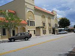 Lyric Theatre |
November 12, 1993 (#93001204) |
59 Southwest Flagler Avenue 27°11′56″N 80°15′17″W |
Stuart | NRHP# 93001204 |
| 8 | Mount Elizabeth Archeological Site | 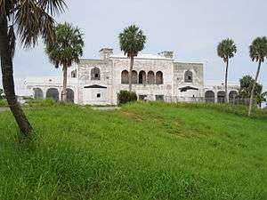 Mount Elizabeth Archeological Site |
September 14, 2002 (#02001011) |
1707 Northeast Indian River Drive 27°13′40″N 80°12′48″W |
Jensen Beach | NRHP# 02001011 |
| 9 | Old Martin County Courthouse |  Old Martin County Courthouse |
November 7, 1997 (#97001329) |
80 East Ocean Boulevard 27°12′02″N 80°14′44″W |
Stuart | NRHP# 97001329 |
| 10 | Olympia School |  Olympia School |
December 20, 2002 (#02001534) |
9141 Southeast Apollo St. 27°03′34″N 80°07′53″W |
Hobe Sound | NRHP# 02001534 |
| 11 | Seminole Inn |  Seminole Inn |
May 31, 2006 (#06000442) |
15885 Southwest Warfield Boulevard 27°01′27″N 80°28′10″W |
Indiantown | NRHP# 06000442 |
| 12 | Stuart Welcome Arch |  Stuart Welcome Arch |
September 15, 2004 (#04000971) |
Between 2369 and 2390 Northeast Dixie Highway 27°13′31″N 80°13′13″W |
Jensen Beach | NRHP# 04000971 |
| 13 | Trapper Nelson Zoo Historic District |  Trapper Nelson Zoo Historic District |
October 3, 2006 (#06000918) |
16450 Southeast Federal Highway 26°58′37″N 80°09′49″W |
Hobe Sound | NRHP# 06000918 |
| 14 | Tuckahoe | Tuckahoe |
November 30, 2005 (#05001339) |
1921 Northeast Indian River Drive 27°13′41″N 80°12′48″W |
Jensen Beach | NRHP# 05001339 |
See also
| Wikimedia Commons has media related to National Register of Historic Places in Martin County, Florida. |
References
- The latitude and longitude information provided in this table was derived originally from the National Register Information System, which has been found to be fairly accurate for about 99% of listings. Some locations in this table may have been corrected to current GPS standards.
- "National Register of Historic Places: Weekly List Actions". National Park Service, United States Department of the Interior. Retrieved on June 19, 2020.
- Numbers represent an ordering by significant words. Various colorings, defined here, differentiate National Historic Landmarks and historic districts from other NRHP buildings, structures, sites or objects.
- "National Register Information System". National Register of Historic Places. National Park Service. March 13, 2009.
- The eight-digit number below each date is the number assigned to each location in the National Register Information System database, which can be viewed by clicking the number.
Municipalities and communities of Martin County, Florida, United States | ||
|---|---|---|
| City | | |
| Towns | ||
| Village | ||
| CDPs | ||
| Unincorporated community | ||
This article is issued from Wikipedia. The text is licensed under Creative Commons - Attribution - Sharealike. Additional terms may apply for the media files.