National Register of Historic Places listings in Indian River County, Florida
This is a list of the National Register of Historic Places listings in Indian River County, Florida.
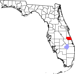
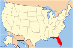
Location of Indian River County in Florida
This is a complete list of the properties and districts on the National Register of Historic Places in Indian River County, Florida, United States. The locations of National Register properties and districts for which the latitude and longitude coordinates are included below, may be seen in a map.[1]
There are 29 properties and districts listed on the National Register in the county, including 1 National Historic Landmark.
- This National Park Service list is complete through NPS recent listings posted June 19, 2020.[2]
| Alachua - Baker - Bay - Bradford - Brevard - Broward - Calhoun - Charlotte - Citrus - Clay - Collier - Columbia - DeSoto - Dixie - Duval - Escambia - Flagler - Franklin - Gadsden - Gilchrist - Glades - Gulf - Hamilton - Hardee - Hendry - Hernando - Highlands - Hillsborough (Tampa) - Holmes - Indian River - Jackson - Jefferson - Lafayette - Lake - Lee - Leon - Levy - Liberty - Madison - Manatee - Marion - Martin - Miami-Dade (Miami) - Monroe - Nassau - Okaloosa - Okeechobee - Orange - Osceola - Palm Beach - Pasco - Pinellas - Polk - Putnam - St. Johns - St. Lucie - Santa Rosa - Sarasota - Seminole - Sumter - Suwannee - Taylor - Union - Volusia - Wakulla - Walton - Washington |
Current listings
| [3] | Name on the Register[4] | Image | Date listed[5] | Location | City or town | Description |
|---|---|---|---|---|---|---|
| 1 | Driftwood Inn and Restaurant |  Driftwood Inn and Restaurant |
August 6, 1994 (#94000751) |
3150 Ocean Drive 27°39′03″N 80°21′19″W |
Vero Beach | |
| 2 | Marian Fell Library |  Marian Fell Library |
October 8, 1996 (#96001059) |
63 North Cypress Street 27°46′15″N 80°36′13″W |
Fellsmere | Part of the Fellsmere MPS |
| 3 | Fellsmere Public School |  Fellsmere Public School |
November 22, 1996 (#96001368) |
22 South Orange Street 27°46′00″N 80°36′11″W |
Fellsmere | Part of the Fellsmere MPS |
| 4 | First Methodist Episcopal Church |  First Methodist Episcopal Church |
December 27, 1996 (#96001521) |
39 North Broadway 27°46′08″N 80°36′04″W |
Fellsmere | Part of the Fellsmere MPS |
| 5 | Judge Henry F. Gregory House |  Judge Henry F. Gregory House |
June 3, 1994 (#94000540) |
2179 10th Avenue 27°38′26″N 80°23′37″W |
Vero Beach | |
| 6 | Hallstrom House |  Hallstrom House |
June 6, 2002 (#02000605) |
1723 Southwest Old Dixie Highway 27°34′16″N 80°22′31″W |
Vero Beach | |
| 7 | Theodore Hausmann Estate |  Theodore Hausmann Estate |
March 14, 1997 (#97000230) |
4800 16th Street 27°37′53″N 80°26′11″W |
Vero Beach | |
| 8 | Frank and Stella Heiser House |  Frank and Stella Heiser House |
November 29, 2017 (#100001862) |
11055 138th Ave. 27°47′47″N 80°36′28″W |
Fellsmere vicinity | |
| 9 | Indian River County Courthouse |  Indian River County Courthouse |
July 19, 1999 (#99000768) |
2145 14th Avenue 27°38′23″N 80°23′59″W |
Vero Beach | |
| 10 | Jungle Trail |  Jungle Trail |
August 1, 2003 (#03000700) |
Between Old Winter Bch Rd. and State Road A1A on Orchid Island 27°44′09″N 80°24′24″W |
Orchid | |
| 11 | Bamma Vickers Lawson House |  Bamma Vickers Lawson House |
July 26, 1990 (#90001116) |
1133 U.S. Route 1 27°48′48″N 80°28′05″W |
Sebastian | |
| 12 | Maher Building | 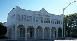 Maher Building |
October 28, 1994 (#94001274) |
1423 20th Street 27°38′18″N 80°24′01″W |
Vero Beach | |
| 13 | McKee Jungle Gardens | 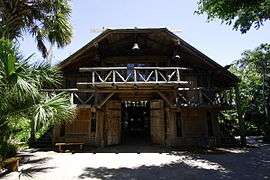 McKee Jungle Gardens |
January 7, 1998 (#97001636) |
350 U.S. Route 1 27°36′29″N 80°23′00″W |
Vero Beach | |
| 14 | Old Palmetto Hotel |  Old Palmetto Hotel |
November 13, 1991 (#91001650) |
1889 Old Dixie Highway 27°38′08″N 80°23′55″W |
Vero Beach | |
| 15 | Old Town Sebastian Historic District, East |  Old Town Sebastian Historic District, East |
August 4, 2003 (#03000728) |
Main and Washington Streets, Riverside Drive, and the Florida East Coast railroad line 27°48′58″N 80°28′09″W |
Sebastian | |
| 16 | Old Town Sebastian Historic District, West |  Old Town Sebastian Historic District, West |
January 6, 2004 (#03001364) |
Bounded by Palmetto Avenue and Lake and Main Streets 27°48′59″N 80°28′23″W |
Sebastian | |
| 17 | Old Vero Beach Community Building | 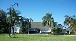 Old Vero Beach Community Building |
January 19, 1993 (#92001746) |
2146 14th Avenue 27°38′24″N 80°23′57″W |
Vero Beach | |
| 18 | Osceola Park Historic Residential District |  Osceola Park Historic Residential District |
January 13, 2013 (#12001196) |
Bounded by 20th & 18th Sts., 20th & 23rd Aves. 27°38′11″N 80°24′27″W |
Vero Beach | |
| 19 | Pelican Island National Wildlife Refuge | 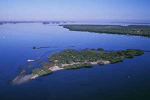 Pelican Island National Wildlife Refuge |
October 15, 1966 (#66000265) |
East of Sebastian in the Indian River 27°48′00″N 80°26′00″W |
Sebastian | |
| 20 | Pueblo Arcade |  Pueblo Arcade |
March 8, 1997 (#97000211) |
2044 14th Street 27°38′23″N 80°24′00″W |
Vero Beach | |
| 21 | Royal Park Arcade |  Royal Park Arcade |
July 31, 1998 (#98000925) |
1059 21st Street 27°38′21″N 80°23′41″W |
Vero Beach | |
| 22 | Sebastian Grammar and Junior High School | 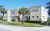 Sebastian Grammar and Junior High School |
August 17, 2001 (#01000889) |
1235 Main St.[6] 27°49′03″N 80°28′32″W |
Sebastian | Now a museum inside the Sebastian City Hall complex. |
| 23 | Archie Smith Wholesale Fish Company |  Archie Smith Wholesale Fish Company |
October 28, 1994 (#94001275) |
1740 Indian River Drive 27°49′46″N 80°28′29″W |
Sebastian | |
| 24 | Spanish Fleet Survivors and Salvors Camp Site | 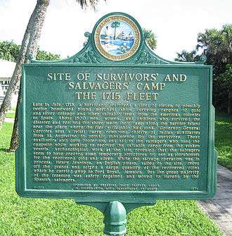 Spanish Fleet Survivors and Salvors Camp Site |
August 12, 1970 (#70000186) |
Address Restricted |
Sebastian | |
| 25 | Treasure Hammock Ranch Farmstead |  Treasure Hammock Ranch Farmstead |
December 11, 2013 (#13000900) |
8005 37th Street 27°39′37″N 80°29′32″W |
Vero Beach vicinity | |
| 26 | Vero Beach Diesel Power Plant |  Vero Beach Diesel Power Plant |
February 26, 1999 (#99000252) |
1246 19th Street 27°38′13″N 80°23′50″W |
Vero Beach | |
| 27 | Vero Beach Woman's Club |  Vero Beach Woman's Club |
February 10, 1995 (#95000051) |
1534 21st Street 27°38′23″N 80°24′00″W |
Vero Beach | |
| 28 | Vero Railroad Station | 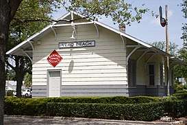 Vero Railroad Station |
January 6, 1987 (#86003560) |
2336 Fourteenth Street 27°38′34″N 80°23′57″W |
Vero Beach | |
| 29 | Vero Theatre |  Vero Theatre |
April 28, 1992 (#92000421) |
2036 14th Avenue 27°38′20″N 80°23′57″W |
Vero Beach |
See also
| Wikimedia Commons has media related to National Register of Historic Places in Indian River County, Florida. |
References
- The latitude and longitude information provided in this table was derived originally from the National Register Information System, which has been found to be fairly accurate for about 99% of listings. Some locations in this table may have been corrected to current GPS standards.
- "National Register of Historic Places: Weekly List Actions". National Park Service, United States Department of the Interior. Retrieved on June 19, 2020.
- Numbers represent an ordering by significant words. Various colorings, defined here, differentiate National Historic Landmarks and historic districts from other NRHP buildings, structures, sites or objects.
- "National Register Information System". National Register of Historic Places. National Park Service. March 13, 2009.
- The eight-digit number below each date is the number assigned to each location in the National Register Information System database, which can be viewed by clicking the number.
- "Sebastian Area Historical Museum". Retrieved April 29, 2016.
Municipalities and communities of Indian River County, Florida, United States | ||
|---|---|---|
| Cities | | |
| Towns | ||
| CDPs | ||
| Unincorporated communities | ||
This article is issued from Wikipedia. The text is licensed under Creative Commons - Attribution - Sharealike. Additional terms may apply for the media files.