National Register of Historic Places listings in Tampa, Florida
This is a list of the National Register of Historic Places listings in Tampa, Florida.

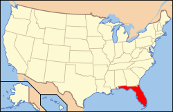
Location of Tampa in Hillsborough County, Florida
This is intended to be a complete list of the properties and districts on the National Register of Historic Places in Tampa, Florida. The locations of National Register properties and districts for which the latitude and longitude coordinates are included below, may be seen in a map.[1]
There are 78 properties and districts listed on the National Register in the city, including 3 National Historic Landmarks. Two other sites were once listed, but have been removed. The 21 properties and districts in Hillsborough County outside Tampa are listed in National Register of Historic Places listings in Hillsborough County, Florida.
- This National Park Service list is complete through NPS recent listings posted June 19, 2020.[2]
| Alachua - Baker - Bay - Bradford - Brevard - Broward - Calhoun - Charlotte - Citrus - Clay - Collier - Columbia - DeSoto - Dixie - Duval - Escambia - Flagler - Franklin - Gadsden - Gilchrist - Glades - Gulf - Hamilton - Hardee - Hendry - Hernando - Highlands - Hillsborough (Tampa) - Holmes - Indian River - Jackson - Jefferson - Lafayette - Lake - Lee - Leon - Levy - Liberty - Madison - Manatee - Marion - Martin - Miami-Dade (Miami) - Monroe - Nassau - Okaloosa - Okeechobee - Orange - Osceola - Palm Beach - Pasco - Pinellas - Polk - Putnam - St. Johns - St. Lucie - Santa Rosa - Sarasota - Seminole - Sumter - Suwannee - Taylor - Union - Volusia - Wakulla - Walton - Washington |
Current listings
| [3] | Name on the Register[4] | Image | Date listed[5] | Location | Neighborhood | Description |
|---|---|---|---|---|---|---|
| 1 | Anderson-Frank House | 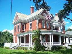 Anderson-Frank House |
April 22, 1982 (#82002375) |
341 Plant Avenue 27°56′21″N 82°27′48″W |
Hyde Park | |
| 2 | Bay Isle Commercial Building |  Bay Isle Commercial Building |
August 3, 1989 (#89000971) |
238 East Davis Boulevard 27°55′33″N 82°27′13″W |
Davis Islands | Part of the Mediterranean Revival Style Buildings of Davis Islands MPS |
| 3 | Centro Asturiano | 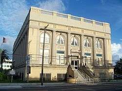 Centro Asturiano |
July 24, 1974 (#74000631) |
1913 Nebraska Avenue 27°57′42″N 82°27′03″W |
V.M. Ybor | |
| 4 | Circulo Cubano de Tampa |  Circulo Cubano de Tampa |
November 15, 1972 (#72000320) |
10th Avenue and 14th Street 27°57′39″N 82°26′42″W |
Ybor City | |
| 5 | William E. Curtis House |  William E. Curtis House |
August 27, 1987 (#87001424) |
808 East Curtis Street 27°59′16″N 82°27′46″W |
Southeast Seminole Heights | |
| 6 | El Centro Español de Tampa | 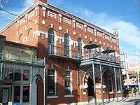 El Centro Español de Tampa |
June 3, 1988 (#88001823) |
1526-1536 East Seventh Avenue 27°57′36″N 82°26′31″W |
Ybor City | |
| 7 | El Centro Espanol of West Tampa |  El Centro Espanol of West Tampa |
July 30, 1974 (#74000632) |
2306 North Howard Street 27°57′41″N 82°29′00″W |
West Tampa | |
| 8 | El Pasaje | 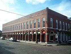 El Pasaje |
November 15, 1972 (#72000321) |
14th Street and Palm Avenue 27°57′42″N 82°26′41″W |
Ybor City | |
| 9 | Episcopal House of Prayer | 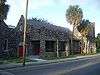 Episcopal House of Prayer |
February 21, 1991 (#91000105) |
2708 Central Avenue 27°58′00″N 82°27′20″W |
Tampa Heights | |
| 10 | Federal Building, U.S. Courthouse, Downtown Postal Station | 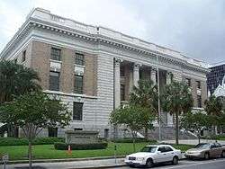 Federal Building, U.S. Courthouse, Downtown Postal Station |
June 7, 1974 (#74000633) |
601 Florida Avenue 27°56′59″N 82°27′27″W |
Downtown Tampa | |
| 11 | First Federal Savings and Loan Association of Tampa |  First Federal Savings and Loan Association of Tampa |
October 17, 2018 (#100003023) |
220 East Madison St. 27°56′54″N 82°27′31″W |
Downtown Tampa | |
| 12 | Floridan Hotel |  Floridan Hotel |
March 12, 1996 (#96000315) |
905 North Florida Avenue 27°57′06″N 82°26′54″W |
Downtown Tampa | |
| 13 | Fort Homer W. Hesterly National Guard Armory | 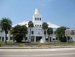 Fort Homer W. Hesterly National Guard Armory |
October 23, 2013 (#13000852) |
522 N. Howard Ave. 27°56′59″N 82°29′02″W |
West Tampa | |
| 14 | Isaac Gardner, Sr., House |  Isaac Gardner, Sr., House |
October 13, 2003 (#03001013) |
209 West Palm Avenue 27°57′51″N 82°27′47″W |
Tampa Heights | |
| 15 | George Guida, Sr. House |  George Guida, Sr. House |
March 29, 2006 (#06000193) |
1516 North Renfrew Avenue 27°57′31″N 82°29′49″W |
McFarlane Park | |
| 16 | Hampton Terrace Historic District |  Hampton Terrace Historic District |
January 27, 1999 (#99000045) |
Roughly bounded by Hanna Avenue, 15th Street, Hillsborough Avenue, and Nebraska Avenue 27°59′58″N 82°26′50″W |
Old Seminole Heights | |
| 17 | Perry Harvey Sr. Park Skateboard Bowl | 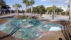 Perry Harvey Sr. Park Skateboard Bowl |
October 7, 2013 (#13000811) |
900 E. Scott St. 27°57′18″N 82°27′20″W |
South Nebraska | Demolished as part of a renovation of Perry Harvey Sr. Park.[6][7] |
| 18 | House at 36 Aegean Avenue |  House at 36 Aegean Avenue |
November 13, 1989 (#89001964) |
36 Aegean Avenue 27°56′04″N 82°27′34″W |
Davis Islands | Part of the Mediterranean Revival Style Buildings of Davis Islands MPS |
| 19 | House at 36 Columbia Drive |  House at 36 Columbia Drive |
August 3, 1989 (#89000966) |
36 Columbia Drive 27°56′05″N 82°27′26″W |
Davis Islands | Part of the Mediterranean Revival Style Buildings of Davis Islands MPS |
| 20 | House at 53 Aegean Avenue |  House at 53 Aegean Avenue |
August 3, 1989 (#89000955) |
53 Aegean Avenue 27°55′58″N 82°27′33″W |
Davis Islands | Part of the Mediterranean Revival Style Buildings of Davis Islands MPS |
| 21 | House at 59 Aegean Avenue |  House at 59 Aegean Avenue |
August 3, 1989 (#89000956) |
59 Aegean Avenue 27°55′57″N 82°27′33″W |
Davis Islands | Part of the Mediterranean Revival Style Buildings of Davis Islands MPS |
| 22 | House at 84 Adalia Avenue |  House at 84 Adalia Avenue |
August 3, 1989 (#89000953) |
84 Adalia Avenue 27°55′51″N 82°27′40″W |
Davis Islands | Part of the Mediterranean Revival Style Buildings of Davis Islands MPS |
| 23 | House at 97 Adriatic Avenue |  House at 97 Adriatic Avenue |
August 3, 1989 (#89000954) |
97 Adriatic Avenue 27°55′55″N 82°27′37″W |
Davis Islands | Part of the Mediterranean Revival Style Buildings of Davis Islands MPS |
| 24 | House at 100 West Davis Boulevard |  House at 100 West Davis Boulevard |
August 3, 1989 (#89000972) |
100 West Davis Boulevard 27°55′48″N 82°27′25″W |
Davis Islands | Part of the Mediterranean Revival Style Buildings of Davis Islands MPS |
| 25 | House at 116 West Davis Boulevard | 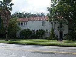 House at 116 West Davis Boulevard |
August 3, 1989 (#89000973) |
116 West Davis Boulevard 27°55′42″N 82°27′27″W |
Davis Islands | Part of the Mediterranean Revival Style Buildings of Davis Islands MPS |
| 26 | House at 124 Baltic Circle | 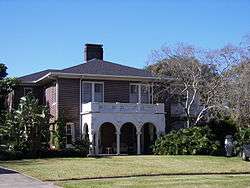 House at 124 Baltic Circle |
August 3, 1989 (#89000957) |
124 Baltic Circle 27°55′48″N 82°27′33″W |
Davis Islands | Part of the Mediterranean Revival Style Buildings of Davis Islands MPS |
| 27 | House at 125 Baltic Circle |  House at 125 Baltic Circle |
August 3, 1989 (#89000958) |
125 Baltic Circle 27°55′48″N 82°27′30″W |
Davis Islands | Part of the Mediterranean Revival Style Buildings of Davis Islands MPS |
| 28 | House at 131 West Davis Boulevard | 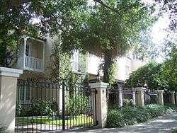 House at 131 West Davis Boulevard |
January 8, 1990 (#89002161) |
131 West Davis Boulevard 27°55′38″N 82°27′28″W |
Davis Islands | Part of the Mediterranean Revival Style Buildings of Davis Islands MPS |
| 29 | House at 132 Baltic Circle | 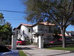 House at 132 Baltic Circle |
August 3, 1989 (#89000959) |
132 Baltic Circle 27°55′46″N 82°27′31″W |
Davis Islands | Part of the Mediterranean Revival Style Buildings of Davis Islands MPS |
| 30 | House at 161 Bosporous Avenue |  House at 161 Bosporous Avenue |
August 3, 1989 (#89000963) |
161 Bosporous Avenue 27°55′33″N 82°27′26″W |
Davis Islands | Part of the Mediterranean Revival Style Buildings of Davis Islands MPS |
| 31 | House at 190 Bosporous Avenue |  House at 190 Bosporous Avenue |
August 3, 1989 (#89000964) |
190 Bosporous Avenue 27°55′31″N 82°27′27″W |
Davis Islands | Part of the Mediterranean Revival Style Buildings of Davis Islands MPS |
| 32 | House at 200 Corsica Avenue |  House at 200 Corsica Avenue |
August 3, 1989 (#89000967) |
200 Corsica Avenue 27°55′31″N 82°27′38″W |
Davis Islands | Part of the Mediterranean Revival Style Buildings of Davis Islands MPS |
| 33 | House at 202 Blanca Avenue |  House at 202 Blanca Avenue |
August 3, 1989 (#89000960) |
202 Blanca Avenue 27°55′36″N 82°27′42″W |
Davis Islands | Part of the Mediterranean Revival Style Buildings of Davis Islands MPS |
| 34 | House at 220 Blanca Avenue | 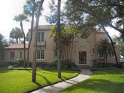 House at 220 Blanca Avenue |
August 3, 1989 (#89000961) |
220 Blanca Avenue 27°55′31″N 82°27′39″W |
Davis Islands | Part of the Mediterranean Revival Style Buildings of Davis Islands MPS |
| 35 | House at 301 Caspian Street | 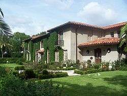 House at 301 Caspian Street |
August 3, 1989 (#89000965) |
301 Caspian Street 27°55′27″N 82°27′34″W |
Davis Islands | Part of the Mediterranean Revival Style Buildings of Davis Islands MPS |
| 36 | House at 418 Blanca Avenue | 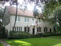 House at 418 Blanca Avenue |
August 3, 1989 (#89000962) |
418 Blanca Avenue 27°55′17″N 82°27′33″W |
Davis Islands | Part of the Mediterranean Revival Style Buildings of Davis Islands MPS |
| 37 | Hutchinson House |  Hutchinson House |
November 1, 1977 (#77000404) |
304 Plant Avenue 27°56′28″N 82°27′46″W |
Hyde Park | |
| 38 | Hyde Park Historic Districts |  Hyde Park Historic Districts |
March 4, 1985 (#85000454) |
Roughly bounded by the Hillsborough River and Bay, Howard Avenue, and Kennedy Boulevard 27°56′11″N 82°28′23″W |
Hyde Park | |
| 39 | Captain William Parker Jackson House | 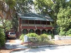 Captain William Parker Jackson House |
April 8, 2011 (#11000159) |
800 E Lambright St 28°00′24″N 82°27′09″W |
Old Seminole Heights | |
| 40 | Jackson Rooming House |  Jackson Rooming House |
March 7, 2007 (#07000112) |
851 Zack Street 27°57′08″N 82°27′07″W |
Downtown Tampa | |
| 41 | Johnson-Wolff House |  Johnson-Wolff House |
July 24, 1974 (#74000634) |
6823 South DeSoto Street 27°51′59″N 82°31′34″W |
Port Tampa City | |
| 42 | S. H. Kress and Co. Building |  S. H. Kress and Co. Building |
April 7, 1983 (#83001424) |
811 North Franklin Street 27°57′03″N 82°27′34″W |
Downtown Tampa | |
| 43 | Lafayette Street Bridge | .jpg) Lafayette Street Bridge |
February 20, 2018 (#100002094) |
Kennedy Boulevard over Hillsboro R. 27°56′48″N 82°27′40″W |
Downtown Tampa | Better known today as the Kennedy Blvd. Drawbridge. |
| 44 | LeClaire Apartments | 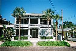 LeClaire Apartments |
November 16, 1988 (#88001697) |
3013-3015 San Carlos 27°55′22″N 82°29′37″W |
Palma Ceia | |
| 45 | Leiman House | 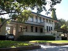 Leiman House |
September 9, 1974 (#74000635) |
716 South Newport Street 27°56′08″N 82°28′18″W |
Hyde Park | |
| 46 | Masonic Temple No. 25 | 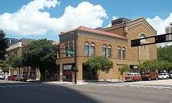 Masonic Temple No. 25 |
September 11, 1986 (#86002415) |
508 East Kennedy Boulevard 27°56′54″N 82°27′04″W |
Downtown Tampa | |
| 47 | Meacham Elementary School | Meacham Elementary School |
September 15, 2005 (#05001041) |
1225 India Street 27°57′19″N 82°27′11″W |
South Nebraska | Part of the Florida's Historic Black Public Schools MPS. In 2007, the school building was demolished as part of a redevelopment project of the area.[8] |
| 48 | Michigan Avenue Bridge | 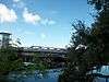 Michigan Avenue Bridge |
September 25, 2017 (#100001669) |
Columbus Dr. over the Hillsborough R. 27°58′00″N 82°28′31″W |
Old West Tampa, Riverside Heights, and Ridgewood Park | Better known today as the Columbus Drive Swing Span Bridge. |
| 49 | North Franklin Street Historic District |  North Franklin Street Historic District |
March 28, 2002 (#02000264) |
Roughly bounded by Florida Avenue and East Fortune, Tampa, Franklin, and East Harrison Streets 27°57′15″N 82°27′37″W |
Downtown Tampa | |
| 50 | Oaklawn and St. Louis Cemeteries Historic District | 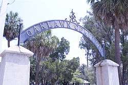 Oaklawn and St. Louis Cemeteries Historic District |
September 25, 2017 (#100001668) |
606 E. Harriston St. 27°57′14″N 82°27′26″W |
Downtown Tampa | |
| 51 | Old Hillsborough County High School | 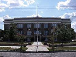 Old Hillsborough County High School |
May 15, 2007 (#07000423) |
2704 North Highland Avenue 27°58′05″N 82°27′47″W |
Tampa Heights | |
| 52 | Old People's Home |  Old People's Home |
October 17, 2000 (#00001198) |
1203 East 22nd Avenue 27°57′41″N 82°26′48″W |
V.M. Ybor | |
| 53 | Old School House | 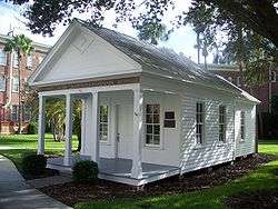 Old School House |
December 4, 1974 (#74000636) |
Lafayette Street on the University of Tampa campus 27°56′48″N 82°27′55″W |
University of Tampa | |
| 54 | Old Tampa Children's Home |  Old Tampa Children's Home |
July 22, 1999 (#99000863) |
3302 North Tampa Avenue 27°58′27″N 82°27′35″W |
Tampa Heights | |
| 55 | Old Tampa Free Public Library | 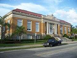 Old Tampa Free Public Library |
May 16, 1991 (#91000618) |
102 East Seventh Avenue 27°57′37″N 82°27′38″W |
Tampa Heights | |
| 56 | Old Union Depot Hotel | 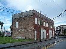 Old Union Depot Hotel |
December 11, 2000 (#00001228) |
858 East Zack Street 27°57′10″N 82°27′05″W |
Downtown Tampa | Demolished[9] |
| 57 | Original Rogers Park Golf Course Site | 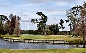 Original Rogers Park Golf Course Site |
November 12, 2014 (#14000901) |
7801 N. 30th St. 28°01′20″N 82°25′25″W |
Old Seminole Heights | |
| 58 | Palace of Florence Apartments |  Palace of Florence Apartments |
August 3, 1989 (#89000969) |
45 East Davis Boulevard 27°56′02″N 82°27′28″W |
Davis Islands | Part of the Mediterranean Revival Style Buildings of Davis Islands MPS |
| 59 | Palmerin Hotel | 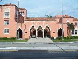 Palmerin Hotel |
August 3, 1989 (#89000970) |
115 East Davis Boulevard 27°55′46″N 82°27′22″W |
Davis Islands | Part of the Mediterranean Revival Style Buildings of Davis Islands MPS |
| 60 | Palmetto Beach Historic District |  Palmetto Beach Historic District |
August 14, 2012 (#12000496) |
Roughly bounded by Durham, 28th, Thrace, & 22nd Streets 27°56′53″N 82°25′53″W |
Palmetto Beach | |
| 61 | Horace T. Robles House |  Horace T. Robles House |
March 2, 2006 (#06000091) |
2604 East Hanna Avenue 28°00′13″N 82°25′48″W |
Old Seminole Heights | |
| 62 | Roosevelt Elementary School |  Roosevelt Elementary School |
May 31, 2006 (#06000443) |
3205 South Ferdinand Avenue 27°54′59″N 82°29′52″W |
Palma Ceia | |
| 63 | St. Andrews Episcopal Church | 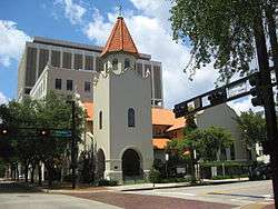 St. Andrews Episcopal Church |
April 15, 2009 (#09000200) |
505 N. Marion St. 27°56′58″N 82°27′24″W |
Downtown Tampa | |
| 64 | Seminole Heights Residential District |  Seminole Heights Residential District |
August 5, 1993 (#93000751) |
Roughly bounded by Osborne, Florida, Hanna, and Cherokee Avenues 27°59′45″N 82°27′25″W |
Old Seminole Heights | |
| 65 | Spanish Apartments | 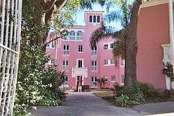 Spanish Apartments |
August 3, 1989 (#89000968) |
16 East Davis Boulevard 27°56′08″N 82°27′35″W |
Davis Islands | Part of the Mediterranean Revival Style Buildings of Davis Islands MPS |
| 66 | SS AMERICAN VICTORY (Victory ship) |  SS AMERICAN VICTORY (Victory ship) |
February 4, 2002 (#01001533) |
705 Channelside Dr., Berth 271 27°56′42″N 82°26′39″W |
Channel District | |
| 67 | Stovall House | 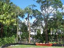 Stovall House |
September 4, 1974 (#74000637) |
4621 Bayshore Boulevard 27°53′47″N 82°29′24″W |
Bayshore Beautiful | |
| 68 | T. C. Taliaferro House |  T. C. Taliaferro House |
October 1, 1974 (#74000638) |
305 South Hyde Park 27°56′28″N 82°27′52″W |
Hyde Park | |
| 69 | Tampa Bay Hotel |  Tampa Bay Hotel |
December 5, 1972 (#72000322) |
401 West Kennedy Boulevard 27°56′46″N 82°27′51″W |
Downtown Tampa | |
| 70 | Tampa City Hall | 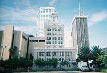 Tampa City Hall |
October 1, 1974 (#74000639) |
315 John F. Kennedy Boulevard, East 27°56′50″N 82°27′27″W |
Downtown Tampa | |
| 71 | Tampa Heights Historic District |  Tampa Heights Historic District |
August 4, 1995 (#95000979) |
Roughly bounded by Adalee Street, Interstate 275, 7th Avenue, and North Tampa Avenue 27°57′54″N 82°27′27″W |
Tampa Heights | |
| 72 | Tampa Theatre and Office Building |  Tampa Theatre and Office Building |
January 3, 1978 (#78000945) |
711 Franklin Street 27°57′00″N 82°27′32″W |
Downtown Tampa | |
| 73 | Tampania House | 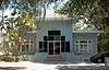 Tampania House |
September 12, 1985 (#85002178) |
4611 North A Street 27°56′45″N 82°30′19″W |
Oakford Park | |
| 74 | Union Railroad Station |  Union Railroad Station |
June 5, 1974 (#74000640) |
601 North Nebraska Street 27°57′08″N 82°27′04″W |
Downtown and Channel District | |
| 75 | Upper North Franklin Street Commercial District |  Upper North Franklin Street Commercial District |
June 9, 2010 (#10000344) |
Bounded by E Oak Ave, N Florida Ave, Kay St, and N Tampa St 27°57′34″N 82°27′37″W |
Tampa Heights | |
| 76 | West Tampa Historic District |  West Tampa Historic District |
October 18, 1983 (#83003539) |
Roughly bounded by Cypress and Ivy Streets, Fremont and Habana Avenues 27°57′34″N 82°29′02″W |
West Tampa | |
| 77 | Ybor City Historic District |  Ybor City Historic District |
August 28, 1974 (#74000641) |
Roughly bounded by 6th Avenue, 13th Street, 10th Avenue and 22nd Street, East Broadway between 13th and 22nd Streets 27°57′45″N 82°26′28″W |
Ybor City | |
| 78 | Ybor Factory Building |  Ybor Factory Building |
November 15, 1972 (#72000323) |
7th Avenue between 13th and 14th Streets 27°57′38″N 82°26′43″W |
Ybor City |
Former listings
| [3] | Name on the Register | Image | Date listed | Date removed | Location | City or town | Summary |
|---|---|---|---|---|---|---|---|
| 1 | Hayden Estate Building |  Hayden Estate Building |
November 1, 1984 (#84000197) | September 15, 1989 | 1016-1016 1/2 N. Franklin St. |
Downtown Tampa | Destroyed by fire in the late 1980s or early 1990s[10] |
| 2 | Levick House |  Levick House |
July 30, 1974 (#74002258) | Unknown | 2202 N. Highland St. |
Tampa Heights |
See also
References
| Wikimedia Commons has media related to National Register of Historic Places in Tampa, Florida. |
- The latitude and longitude information provided in this table was derived originally from the National Register Information System, which has been found to be fairly accurate for about 99% of listings. Some locations in this table may have been corrected to current GPS standards.
- "National Register of Historic Places: Weekly List Actions". National Park Service, United States Department of the Interior. Retrieved on June 19, 2020.
- Numbers represent an ordering by significant words. Various colorings, defined here, differentiate National Historic Landmarks and historic districts from other NRHP buildings, structures, sites or objects.
- "National Register Information System". National Register of Historic Places. National Park Service. March 13, 2009.
- The eight-digit number below each date is the number assigned to each location in the National Register Information System database, which can be viewed by clicking the number.
- "Bro Bowl to be replaced by replica skate park at Perry Harvey Sr. Park". Tampa Bay Times. February 15, 2015. Retrieved January 8, 2020.
- "Tampa's skate community stoked as Bro Bowl 2.0 opens in Perry Harvey Sr. Park". Tampa Bay Times. April 16, 2016. Retrieved January 8, 2020.
- Keith Morelli (November 30, 2007). "Meacham School Razed". Tampa Bay Online. Retrieved July 5, 2011.
- Steele, Kathy. (May 25, 2010). "Station's whites-only hotel razed". The Tampa Tribune. Archived 2007-09-24 at the Wayback Machine Retrieved May 26, 2010.
- "Upper North Franklin Street Commercial District nomination form". National Park Service. Retrieved January 12, 2020.
This article is issued from Wikipedia. The text is licensed under Creative Commons - Attribution - Sharealike. Additional terms may apply for the media files.