National Register of Historic Places listings in Carroll County, Ohio
This is a list of the National Register of Historic Places listings in Carroll County, Ohio.
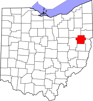
Location of Carroll County in Ohio
It is intended to be a complete list of the properties on the National Register of Historic Places in Carroll County, Ohio, United States. The locations of National Register properties for which the latitude and longitude coordinates are included below, may be seen in a Google map.[1]
There are 11 properties listed on the National Register in the county. Another property was once listed but has been removed.
- This National Park Service list is complete through NPS recent listings posted June 19, 2020.[2]
Current listings
| [3] | Name on the Register[4] | Image | Date listed[5] | Location | City or town | Description |
|---|---|---|---|---|---|---|
| 1 | Carroll County Courthouse |  Carroll County Courthouse |
October 22, 1974 (#74001406) |
Public Sq. 40°34′20″N 81°05′09″W |
Carrollton | |
| 2 | John Herrington House and Herrington Bethel Church |  John Herrington House and Herrington Bethel Church |
January 19, 1983 (#83001949) |
4070 Arbor Rd., NE. 40°38′57″N 81°00′46″W |
Augusta Township | |
| 3 | Patrick Hull House | 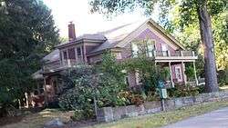 Patrick Hull House |
December 15, 1982 (#82001362) |
8187 Blade Rd., near Oneida 40°42′06″N 81°09′09″W |
Brown Township | |
| 4 | Kilgore Union Presbyterian Church | 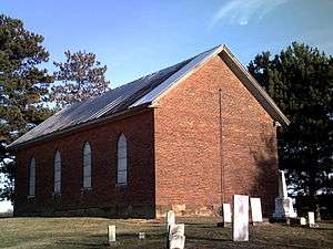 Kilgore Union Presbyterian Church |
March 15, 1995 (#95000166) |
7219 Germano Rd., SE., in Kilgore 40°27′37″N 81°00′00″W |
Loudon Township | |
| 5 | Daniel McCook House |  Daniel McCook House |
November 10, 1970 (#70000486) |
Public Sq. 40°34′19″N 81°05′14″W |
Carrollton | Home of Daniel McCook |
| 6 | Petersburg Mill | 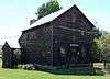 Petersburg Mill |
November 20, 1970 (#70000487) |
4.3 miles south of Carrollton on State Route 332 40°30′46″N 81°06′45″W |
Union Township | |
| 7 | Henry and Mary Pottorf House and Farmstead |  Henry and Mary Pottorf House and Farmstead |
March 9, 1995 (#95000171) |
4071 Meter Rd. 40°39′46″N 81°00′29″W |
Augusta Township | |
| 8 | St. Mary's of Morges | 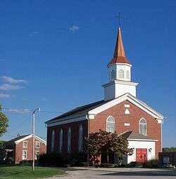 St. Mary's of Morges |
April 11, 1977 (#77001047) |
8012 Bachelor Rd., NW. 40°38′04″N 81°14′33″W |
Rose Township | |
| 9 | Seven Ranges Terminus |  Seven Ranges Terminus |
December 12, 1976 (#76001527) |
West of Magnolia at the junction of Stark, Tuscarawas, and Carroll counties 40°39′07″N 81°19′05″W |
Rose Township | Extends into Stark and Tuscarawas counties |
| 10 | Van Horn Building |  Van Horn Building |
September 3, 1987 (#87001375) |
Public Sq., junction of W. Main and N. Lisbon Sts. 40°34′23″N 81°05′11″W |
Carrollton | |
| 11 | Wheeling and Lake Erie RR Minerva Station | Wheeling and Lake Erie RR Minerva Station |
September 10, 1992 (#92001246) |
301 Valley St. 40°43′33″N 81°06′17″W |
Minerva |
Former listing
| [3] | Name on the Register | Image | Date listed | Date removed | Location | City or town | Summary |
|---|---|---|---|---|---|---|---|
| 1 | Minerva Grade School |  Minerva Grade School |
October 15, 1973 (#73001393) | October 7, 1976 | Southeastern corner of W. Line St. at Grant Boulevard 40°43′40″N 81°06′29″W |
Minerva |
See also
| Wikimedia Commons has media related to National Register of Historic Places in Carroll County, Ohio. |
References
- The latitude and longitude information provided in this table was derived originally from the National Register Information System, which has been found to be fairly accurate for about 99% of listings. Some locations in this table may have been corrected to current GPS standards.
- "National Register of Historic Places: Weekly List Actions". National Park Service, United States Department of the Interior. Retrieved on June 19, 2020.
- Numbers represent an ordering by significant words. Various colorings, defined here, differentiate National Historic Landmarks and historic districts from other NRHP buildings, structures, sites or objects.
- "National Register Information System". National Register of Historic Places. National Park Service. April 24, 2008.
- The eight-digit number below each date is the number assigned to each location in the National Register Information System database, which can be viewed by clicking the number.

Municipalities and communities of Carroll County, Ohio, United States | ||
|---|---|---|
| Villages | Map of Ohio highlighting Carroll County | |
| Townships | ||
| CDP | ||
| Unincorporated communities | ||
| Footnotes | ‡This populated place also has portions in an adjacent county or counties | |
This article is issued from Wikipedia. The text is licensed under Creative Commons - Attribution - Sharealike. Additional terms may apply for the media files.