National Register of Historic Places listings in Holmes County, Ohio
This is a list of the National Register of Historic Places listings in Holmes County, Ohio.
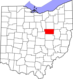
Location of Holmes County in Ohio
This is intended to be a complete list of the properties and districts on the National Register of Historic Places in Holmes County, Ohio, United States. The locations of National Register properties and districts for which the latitude and longitude coordinates are included below, may be seen in a Google map.[1]
There are 16 properties and districts listed on the National Register in the county.
- This National Park Service list is complete through NPS recent listings posted June 19, 2020.[2]
Current listings
| [3] | Name on the Register[4] | Image | Date listed[5] | Location | City or town | Description |
|---|---|---|---|---|---|---|
| 1 | G. Adams House |  G. Adams House |
July 17, 1984 (#84003730) |
103 N. Clay St. 40°33′21″N 81°55′03″W |
Millersburg | |
| 2 | Joseph Armstrong Farm | 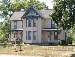 Joseph Armstrong Farm |
November 27, 1978 (#78002088) |
Southeast of Fredericksburg 40°39′55″N 81°51′28″W |
Salt Creek Township | |
| 3 | Boyd School | 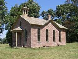 Boyd School |
October 3, 1980 (#80003103) |
Northwest of Berlin on County Road 201 (Fryburg-Fredericksburg-Boyd Rd.) 40°34′47″N 81°49′13″W |
Berlin Township | |
| 4 | Brightman House |  Brightman House |
October 29, 1974 (#74001528) |
Wooster Rd. and Walnut St. 40°33′34″N 81°55′07″W |
Millersburg | |
| 5 | G. W. Cary House |  G. W. Cary House |
July 17, 1984 (#84003734) |
200 N. Washington St. 40°33′20″N 81°55′05″W |
Millersburg | |
| 6 | Hiram W. Cary House |  Hiram W. Cary House |
July 17, 1984 (#84003736) |
101 N. Clay St. 40°33′20″N 81°55′03″W |
Millersburg | |
| 7 | Croco House |  Croco House |
June 20, 1985 (#85001343) |
State Route 83, north of Holmesville 40°38′10″N 81°55′38″W |
Prairie Township | |
| 8 | Joseph L. DeYarmon House | 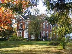 Joseph L. DeYarmon House |
May 4, 1982 (#82003599) |
Southwestern corner of County Road 179 and Township Road 464, southwest of Lakeville 40°39′10″N 82°08′10″W |
Washington Township | |
| 9 | Disciple-Christian Church |  Disciple-Christian Church |
July 17, 1984 (#84003738) |
100 N. Clay St. 40°33′20″N 81°55′01″W |
Millersburg | |
| 10 | Holmes County Courthouse and Jail |  Holmes County Courthouse and Jail |
July 25, 1974 (#74001529) |
Courthouse Sq. 40°33′14″N 81°55′02″W |
Millersburg | |
| 11 | John E. Koch Jr. House |  John E. Koch Jr. House |
July 17, 1984 (#84003740) |
107 N. Washington St. 40°33′23″N 81°55′07″W |
Millersburg | |
| 12 | Millersburg Historic District |  Millersburg Historic District |
July 17, 1984 (#84003743) |
Jackson, Clay, and Washington Sts. 40°33′15″N 81°55′05″W |
Millersburg | |
| 13 | Pomerene House |  Pomerene House |
October 20, 1980 (#80003102) |
U.S. Route 62 in Berlin 40°33′41″N 81°47′42″W |
Berlin Township | |
| 14 | Shull-Lugenbuhl Farm |  Shull-Lugenbuhl Farm |
April 26, 1979 (#79001866) |
North of Winesburg 40°38′04″N 81°41′47″W |
Paint Township | |
| 15 | United Methodist Church |  United Methodist Church |
July 17, 1984 (#84003744) |
N. Washington St. 40°33′21″N 81°55′08″W |
Millersburg | |
| 16 | Peter Wise House | April 16, 1980 (#80003104) |
South of Berlin on State Route 557 40°31′52″N 81°48′36″W |
Berlin Township | Dismantled in 2008 and pieces scattered among various locations[6] |
See also
| Wikimedia Commons has media related to National Register of Historic Places in Holmes County, Ohio. |
References
- The latitude and longitude information provided in this table was derived originally from the National Register Information System, which has been found to be fairly accurate for about 99% of listings. Some locations in this table may have been corrected to current GPS standards.
- "National Register of Historic Places: Weekly List Actions". National Park Service, United States Department of the Interior. Retrieved on June 19, 2020.
- Numbers represent an ordering by significant words. Various colorings, defined here, differentiate National Historic Landmarks and historic districts from other NRHP buildings, structures, sites or objects.
- "National Register Information System". National Register of Historic Places. National Park Service. April 24, 2008.
- The eight-digit number below each date is the number assigned to each location in the National Register Information System database, which can be viewed by clicking the number.
- Baker, Jon. "A Greek Revival", The Times-Reporter, 2008-05-25. Accessed 2015-01-21.

Municipalities and communities of Holmes County, Ohio, United States | ||
|---|---|---|
| Villages | Map of Ohio highlighting Holmes County | |
| Townships | ||
| CDPs | ||
| Unincorporated communities | ||
| Footnotes | ‡This populated place also has portions in an adjacent county or counties | |
This article is issued from Wikipedia. The text is licensed under Creative Commons - Attribution - Sharealike. Additional terms may apply for the media files.