National Register of Historic Places listings in Defiance County, Ohio
This is a list of the National Register of Historic Places listings in Defiance County, Ohio.
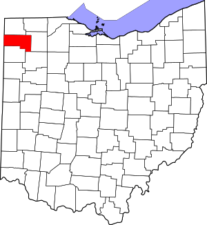
Location of Defiance County in Ohio
This is intended to be a complete list of the properties and districts on the National Register of Historic Places in Defiance County, Ohio, United States. The locations of National Register properties and districts for which the latitude and longitude coordinates are included below, may be seen in an online map.[1]
There are 12 properties and districts listed on the National Register in the county. Another property was once listed but has been removed.
- This National Park Service list is complete through NPS recent listings posted June 19, 2020.[2]
Current listings
| [3] | Name on the Register[4] | Image | Date listed[5] | Location | City or town | Description |
|---|---|---|---|---|---|---|
| 1 | Brooke Site |  Brooke Site |
January 1, 1976 (#76001412) |
Between Watson Rd. and the Auglaize River, east of the Ohio Power Dam[6] 41°14′18″N 84°23′43″W |
Defiance Township | |
| 2 | Defiance Downtown Historic District | March 5, 2020 (#100005021) |
Roughly bounded by Fort, Clinton, Arabella, and Wayne Sts. 41°17′05″N 84°21′46″W |
Defiance | ||
| 3 | Defiance High School | September 9, 2019 (#100004356) |
629 Arabella St. 41°16′54″N 84°21′54″W |
Defiance | Former school, now houses school administration. | |
| 4 | Defiance Public Library |  Defiance Public Library |
October 31, 1985 (#85003446) |
320 Fort St. 41°17′16″N 84°21′31″W |
Defiance | |
| 5 | Dey Road Bridge | 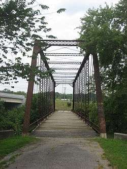 Dey Road Bridge |
February 5, 1999 (#99000095) |
0.35 miles east of U.S. Route 24, west of Defiance 41°17′25″N 84°23′08″W |
Noble Township | |
| 6 | East Side Fire Station |  East Side Fire Station |
December 12, 1976 (#76001413) |
Douglas and Hopkins Sts. 41°16′51″N 84°21′05″W |
Defiance | |
| 7 | Fort Defiance Park | 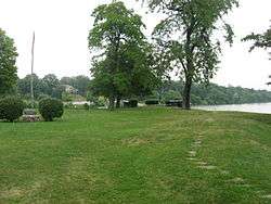 Fort Defiance Park |
June 23, 1980 (#80002989) |
Fort St. 41°17′15″N 84°21′24″W |
Defiance | |
| 8 | Holgate Avenue Historic District | 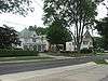 Holgate Avenue Historic District |
October 11, 1990 (#90001497) |
328-716 Holgate Ave. 41°17′09″N 84°22′10″W |
Defiance | |
| 9 | Judge Alexander Latty House | 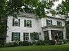 Judge Alexander Latty House |
January 25, 1991 (#90002214) |
718 Perry St. 41°16′50″N 84°22′22″W |
Defiance | |
| 10 | Riverside Chapel |  Riverside Chapel |
April 11, 1977 (#77001058) |
S. Clinton St. in Riverside Cemetery 41°16′24″N 84°22′42″W |
Defiance | |
| 11 | Charles Speaker House |  Charles Speaker House |
April 25, 1997 (#97000374) |
912 Holgate Ave. 41°16′57″N 84°22′28″W |
Defiance | |
| 12 | St. Paul's Episcopal Church |  St. Paul's Episcopal Church |
June 7, 1976 (#76001414) |
High St. 41°17′31″N 84°45′49″W |
Hicksville |
Former listing
| [3] | Name on the Register | Image | Date listed | Date removed | Location | City or town | Summary |
|---|---|---|---|---|---|---|---|
| 1 | Sauer-Watson House |  Sauer-Watson House |
April 12, 1978 (#78002054) | January 1, 1999 | 530 Washington Street 41°16′58″N 84°21′37″W |
Defiance |
See also
| Wikimedia Commons has media related to National Register of Historic Places in Defiance County, Ohio. |
References
- The latitude and longitude information provided in this table was derived originally from the National Register Information System, which has been found to be fairly accurate for about 99% of listings. Some locations in this table may have been corrected to current GPS standards.
- "National Register of Historic Places: Weekly List Actions". National Park Service, United States Department of the Interior. Retrieved on June 19, 2020.
- Numbers represent an ordering by significant words. Various colorings, defined here, differentiate National Historic Landmarks and historic districts from other NRHP buildings, structures, sites or objects.
- "National Register Information System". National Register of Historic Places. National Park Service. April 24, 2008.
- The eight-digit number below each date is the number assigned to each location in the National Register Information System database, which can be viewed by clicking the number.
- Buchman, Randall L., ed. Brook [sic] Site (De3). Defiance: Defiance College, 1974, 1.

Municipalities and communities of Defiance County, Ohio, United States | ||
|---|---|---|
| City | Map of Ohio highlighting Defiance County | |
| Villages | ||
| Townships | ||
| Unincorporated communities | ||
| Ghost towns | ||
This article is issued from Wikipedia. The text is licensed under Creative Commons - Attribution - Sharealike. Additional terms may apply for the media files.