National Register of Historic Places listings in Wayne County, Ohio
This is a list of the National Register of Historic Places listings in Wayne County, Ohio.

Location of Wayne County in Ohio
This is intended to be a complete list of the properties and districts on the National Register of Historic Places in Wayne County, Ohio, United States. The locations of National Register properties and districts for which the latitude and longitude coordinates are included below, may be seen in a Google map.[1]
There are 18 properties and districts listed on the National Register in the county.
- This National Park Service list is complete through NPS recent listings posted June 26, 2020.[2]
Current listings
| [3] | Name on the Register[4] | Image | Date listed[5] | Location | City or town | Description |
|---|---|---|---|---|---|---|
| 1 | James Akey Farm |  James Akey Farm |
December 22, 1978 (#78002212) |
North of Brenneman Rd., southeast of Mt. Eaton[6] 40°40′40″N 81°39′18″W |
Paint Township | Also known as the Starks Wilderness Center Pioneer Farm[4] |
| 2 | Ault-Weygandt Farm |  Ault-Weygandt Farm |
January 14, 2002 (#01001481) |
15090 Back Massillon Rd., northeast of Orrville 40°52′37″N 81°42′38″W |
Baughman Township | |
| 3 | Barnet-Hoover Log House |  Barnet-Hoover Log House |
August 13, 1974 (#74001648) |
Northwest of downtown Orrville 40°51′40″N 81°47′20″W |
Orrville | |
| 4 | Gen. Reasin Beall House |  Gen. Reasin Beall House |
June 7, 1976 (#76001548) |
546 E. Bowman St. 40°48′20″N 81°56′00″W |
Wooster | |
| 5 | College of Wooster | 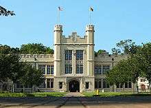 College of Wooster |
February 25, 1980 (#80003246) |
State Route 3 40°48′37″N 81°56′07″W |
Wooster | |
| 6 | Deerlick Farm | 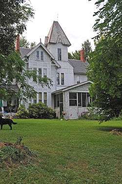 Deerlick Farm |
June 20, 1986 (#86001365) |
7482 Britton Rd., east of West Salem 40°58′14″N 82°04′06″W |
Congress Township | |
| 7 | Charles Gasche House |  Charles Gasche House |
January 13, 1989 (#88003192) |
340 Bever St. 40°48′07″N 81°56′17″W |
Wooster | |
| 8 | Gertenslager Carriage and Wagon Company |  Gertenslager Carriage and Wagon Company |
February 13, 1986 (#86000240) |
572 E. Liberty St. 40°47′57″N 81°55′57″W |
Wooster | |
| 9 | Green Township High School | 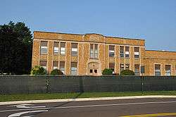 Green Township High School |
September 4, 2013 (#13000684) |
484 E. Main St. 40°52′01″N 81°51′17″W |
Smithville | Demolished in 2014[7] |
| 10 | Kister Mill | 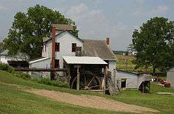 Kister Mill |
July 10, 1974 (#74001647) |
Junction of Township Roads 34 and 228 at Millbrook 40°43′35″N 82°00′17″W |
Clinton Township | |
| 11 | Liggett-Freedlander House | 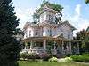 Liggett-Freedlander House |
July 22, 1994 (#94000770) |
408 N. Bever St. 40°48′09″N 81°56′17″W |
Wooster | |
| 12 | John McSweeney House |  John McSweeney House |
July 30, 1974 (#74001649) |
531 N. Market St. 40°48′13″N 81°56′28″W |
Wooster | |
| 13 | Old Wayne County Jail | 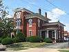 Old Wayne County Jail |
April 29, 1982 (#82003665) |
W. North St. 40°47′58″N 81°56′30″W |
Wooster | |
| 14 | Orrville Downtown Historic District |  Orrville Downtown Historic District |
June 15, 2011 (#11000370) |
Market St. roughly between High & Main 40°50′26″N 81°45′52″W |
Orrville | |
| 15 | Overholt House |  Overholt House |
December 6, 1983 (#83004345) |
1473 Beall Ave. 40°48′55″N 81°56′02″W |
Wooster | |
| 16 | Walnut Street School |  Walnut Street School |
March 1, 1984 (#84003811) |
237 S. Walnut St. 40°47′47″N 81°56′29″W |
Wooster | |
| 17 | Wayne County Courthouse District | .jpg) Wayne County Courthouse District |
July 26, 1973 (#73001551) |
Liberty and Market Sts. 40°47′55″N 81°56′26″W |
Wooster | |
| 18 | Ezekiel B. Zimmerman Octagon House | .jpg) Ezekiel B. Zimmerman Octagon House |
May 28, 1975 (#75001553) |
Northwest of Marshallville on State Route 57 40°55′22″N 81°45′47″W |
Chippewa Township |
See also
| Wikimedia Commons has media related to National Register of Historic Places in Wayne County, Ohio. |
References
- The latitude and longitude information provided in this table was derived originally from the National Register Information System, which has been found to be fairly accurate for about 99% of listings. Some locations in this table may have been corrected to current GPS standards.
- "National Register of Historic Places: Weekly List Actions". National Park Service, United States Department of the Interior. Retrieved on June 26, 2020.
- Numbers represent an ordering by significant words. Various colorings, defined here, differentiate National Historic Landmarks and historic districts from other NRHP buildings, structures, sites or objects.
- "National Register Information System". National Register of Historic Places. National Park Service. April 24, 2008.
- The eight-digit number below each date is the number assigned to each location in the National Register Information System database, which can be viewed by clicking the number.
- Location derived from this Archived 2010-11-30 at the Wayback Machine map, showing this as the only Wilderness Center location near Mount Eaton. The NRIS lists the site as "Address Restricted".
- Doohan, Thomas (May 27, 2014). "Greene Middle School demolition moving forward". The Daily Record. Retrieved November 17, 2016.

Municipalities and communities of Wayne County, Ohio, United States | ||
|---|---|---|
| Cities | Map of Ohio highlighting Wayne County | |
| Villages | ||
| Townships | ||
| CDPs | ||
| Unincorporated communities | ||
| Footnotes | ‡This populated place also has portions in an adjacent county or counties | |
This article is issued from Wikipedia. The text is licensed under Creative Commons - Attribution - Sharealike. Additional terms may apply for the media files.