Modi'in-Maccabim-Re'ut
Modi'in-Maccabim-Re'ut (Hebrew: מוֹדִיעִין-מַכַּבִּים-רֵעוּת) is an Israeli city located in central Israel, about 35 kilometres (22 mi) southeast of Tel Aviv and 30 kilometres (19 mi) west of Jerusalem, and is connected to those two cities via Highway 443. In 2018 the population was 92,406.[1] The population density in that year was 1,794 people per square kilometer.
Modi'in-Maccabim-Re'ut
| |
|---|---|
 | |
 | |
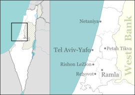 Modi'in-Maccabim-Re'ut Location within Israel  Modi'in-Maccabim-Re'ut Modi'in-Maccabim-Re'ut (Israel) | |
| Coordinates: 31°54′27.55″N 35°0′27.41″E | |
| Country | |
| District | Central |
| Founded | 2003 (merger) 1993 (Modi'in) 1985 (Maccabim) 1987 (Re'ut) |
| Government | |
| • Type | City (from 2003) |
| • Mayor | Haim Bibas |
| Area | |
| • Total | 50,176 dunams (50.176 km2 or 19.373 sq mi) |
| Population (2018)[1] | |
| • Total | 92,406 |
| • Density | 1,800/km2 (4,800/sq mi) |
| Website | http://www.modiin.muni.il |
A part of the city (the Maccabim neighborhood) is not recognized by the European Union as being in Israel, as it lies in what the 1949 Armistice Agreement with Jordan left as a no man's land, and was occupied in 1967 by Israel after it was captured from Jordan together with the West Bank proper.[2][3]
Etymology
The name "Modi'in" (Hebrew: מודיעין) derives from the village "Modi'im"[4] of the high priest Mattathias and his five sons, which was located in the same area as the modern city. The name "Maccabim" is Hebrew for the Maccabees and is a common nickname given to Mattathias and his five sons.
Pre-modern history
Antiquity
In Ancient Israel, a town named Modi'in existed in the general area the modern city is located in. It was the place of origin of the Maccabees, the family who started and led the Jewish revolt against the Seleucid rule over Judea and the Hellenisation of its Jewish population. The Maccabees eventually formed the Hasmonean dynasty that ruled Judea in the 2nd and 1st centuries BCE.[5][6]
Ancient Jewish artifacts believed to date to the First Temple and Hasmonean periods have been found in the area.[5][6]
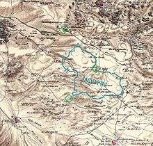
Identification of ancient Modi'in
Modern Modi'in is located near the site of the ancient Modi'in described in the Talmud, though the specific location is uncertain. Possibilities are Suba, Umm el-'Umdan near Route 20 to Canada Park and Latrun, al-Midya, and Khirbet el-Burj (Titura[7][8][9]/Horbat Tittora).
Umm el-Umdan
Umm el-Umdan in an archaeological hilltop site near the southern Moriah (Buchman) neighbourhood of Maccabim Reut, towards Latrun Junction. The six main settlement strata excavated date to the Persian, Hellenistic, Roman, Byzantine, and Early Islamic periods. However, the main findings are from a rural settlement from the Hasmonean through to the Early Roman periods. It contains the remains of a synagogue dated to the end of the 2nd-beginning of the 1st century BCE (Hasmonean period), in use till 132 CE (Bar Kokhba revolt). It has a 1st century CE mikveh standing next to it.[13]
Modern city
Maccabim-Re'ut
In 1985, the construction of the town of Maccabim, which was led by the International Maccabi organization began, and the project of founding nearby Re'ut, led by an association of Israeli army officers, started in 1987. The towns were united into Maccabim-Re'ut in 1990.
According to ARIJ, Israel confiscated land from two Palestinian villages for the construction of Maccabim, presently part of Modi'in-Maccabim-Re'ut: 1,499 dunams from Beit Sira[14] and 471 dunams from Saffa.[15][16]
Modi'in
The cornerstone of Modi'in was laid in 1993. It was built as a modern planned city with high standards of urban planning. Environmental issues and future growth were taken into consideration from the early design stages. Large greenspaces were incorporated into the city's layout and comprise 50% of the area within the city limits. The city was opened for residency in 1996.
Modi'in-Maccabim-Re'ut
In 2003, the Israeli Interior Ministry unified Modi'in and Maccabim-Reut into a single city.
Population development
Modi'in has become a magnet for Jerusalem residents displeased with the capital's growing Haredi character.[17] Thousands of residents of Rosh HaAyin, Lod, and Ramla have also relocated to Modi'in.[17] In 2008, it was decided to cap the growth of Modi'in to allow for the development of Lod and Ramla.[17] The city was planned by the well-known architect Moshe Safdie.
Territorial status controversy
In 2012, the European Union reclassified the small part of Modi'in originally founded as the community of Maccabim as a West Bank settlement since it had been established in the Latrun salient no man's land according to the 1949 Armistice Agreement. The effect of this redefinition was to deny the affected area (which is exclusively green-leaf residential) a range of preferential tax benefits that would normally be conceded on Israeli products exported to Europe.[3] The decision was made to implement a 2010 ruling of the Court of Justice of the European Union.[3] The move sparked off a diplomatic controversy.
Socio-economic status
According to the Israel Central Bureau of Statistics, the city is rated at level 8 out of 10 on the scale of socio-economic development, with a high proportion of high school graduation, 76.5% (2006–07), and an average monthly income of 9,659 NIS, compared to a national average of 7,466 (2006). Modi'in has attracted a large community of olim (Jewish immigrants) from English-speaking countries.[18]
City plan

The original city of Modi'in is laid out around a central hub, with the main arterial spokes organized as dual carriageways. Each side of the artery is a one-way street, and in between is a wide green space, with linear parks, playgrounds, schools, and some small commercial centers. Short lateral stubs fed by continuous-flow intersection turn lanes allow drivers to traverse the green spaces and effect a U-turn onto the artery's opposite direction lanes. These stubs also serve as the entranceways for the schools and mini-malls, preventing parking traffic from blocking the high-speed, left lanes of the arteries. The right shoulders of most arteries do, however, allow parking, except in the pullouts for bus stops, next to fire hydrants, etc.
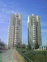
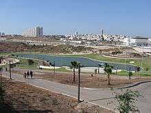
The city center is a large traffic circle punctuated by traffic lights. On the north side of the circle is the central train station, to the northeast is the Azrieli shopping mall (pictured), and to the west and south is the Anaba park (also pictured), which contains a small artificial lake used for recreational boating. The traffic circle straddles a major northeast–southwest artery, HaHashmona'im Blvd., that connects to the southwest with route 431 (which has its eastern terminus in south Modi'in and extends west to Rishon LeZion), and to the northeast with route 443 (at Shilat Junction) providing connectivity to Jerusalem (southeast) and Lod (northwest).
Approximately 5 km (3 miles) west-northwest of the city center is an industrial zone, and to the west (on route 431) is the Yishpro commercial center. The latter is also accessible via an additional Modi'in train station, Paatei Modi'in (Hebrew: פאתי מודיעין, "Modi'in outskirts"). The industrial zone is also linked to route 443 via its own interchange, between Shilat Junction and the Maccabim Junction at the eastern side of the Ben Shemen JNF forest. This keeps most of the commercial traffic out of the city proper, so that the two arteries between the city and its industrial zone (Emek HaEla and HaShdera Hamerkazit) carry primarily commuters rather than trucks.
The long-term projection of the Ministry of Housing is for the city to be home to 240,000 residents. However, plans approved thus far are for 120,000 residents.
Neighborhoods
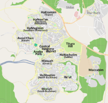

השבטים HaShvatim - The Tribes (North Buchman/Buchman) and מוריה Moriah (South Buchman) are the most southern neighborhoods in the city. Most of the buildings in this neighborhood are ground-level private homes and condos. The streets of Shvatim are named after the tribes of Israel, and the streets of Moriah are named after ancient historical Jewish figures. Moriah, the name of the southern neighborhood, is also a feminine name representing these women.
הפרחים HaPrachim - The Flowers (Miromi) is a small neighborhood in the city center. Located in HaPrachim is a commercial center, two primary schools and a secondary school. The neighborhood's streets are named after trees, flowers, and plants. At the northern part of the neighborhood there is a small compound where the streets are named after phrases from the Song of Songs.
הנחלים HaNachlim - The Rivers (Safdie) and משואה Masuah - Beacon (Givat C) are located towards the west of the city, and were planned by architect Moshe Safdie. Located in these neighborhoods are five commercial centers, a secondary school and three primary schools. The central street names are named after valleys in Israel, and the side streets are named after Israeli rivers and streets. The name "Masuah" was selected in order to represent the neighborhood's high altitude. Within the area consisting of the streets named after rivers and streams is the "Malibu" area, which, as with other areas, is colloquially named after the contractor who designed the neighborhood.
הכרמים HaKramim - The Vineyards (Tsipor) is the northernmost neighborhood in Modi'in. The streets are named after the Hebrew months. The name "Kramim" is in honor of the vineyards that were located where the neighborhood now stands before the city was founded.
אבני חן Avnei Chen - Precious Stones (Kaizer) is located towards the west of the city, and parts of it are still under construction. The main road is named "Avnei Choshen" and leads to the only retail under residential mixed use buildings in Modi'in. Other streets, in keeping with the neighborhood's name, are named for precious stones. The parks are connected through the center of the neighborhood and allow pedestrians to cross. A bike lane in the Emek Zvuloon street leads to the center of town.
הנביאים HaNevi'im - The Prophets (Northern Shimshoni) and המגינים HaMeginim - The Defenders (Southern Shimshoni) are located towards the northwest of the city. Streets in HaNevi'im are named for the Prophets of Israel, while HaMeginim's streets are named after generals and important battles in Israeli history. Located in the neighborhoods are three commercial centers, three primary schools, and one secondary school.
הציפורים HaTsiporim - The Birds (South Kaizer) is still being planned. Its streets will be named after different species of birds, and will be a relatively small neighborhood consisting of only seven streets.
Culture

Sports
Baseball
In 2007, Modi'in was selected as one of the inaugural cities for the Israel Baseball League. The baseball team was named the Modi'in Miracle, but did not play games in Modi'in as there is no baseball stadium there.
American Football
In 2008, the Pioneers of the Israeli Football League (American Football) relocated to Modi'in. The Pioneers played all their home games in Modi'in. In their first year, the Modi'in "Dancing Camel" Pioneers won the IFL Championship. After an unsuccessful 2009–10 season, their second in Modi'in, the Pioneers relocated once again to Tel Aviv, where most of the team's players lived.
Transportation

Modi'in-Maccabim-Re'ut is accessible by Road 431, Highway 3 and Road 443.
A Israel Railways line began operation on April 1, 2008 to a large underground station in Modi'in. Service began in September 2007 to Paatei Modi'in on the western outskirts of the city. This railway connects Modi'in to Tel Aviv by way of Ben Gurion Airport. The line to Modi'in is a spur off the high-speed railway to Jerusalem, currently due for completion in 2016. Once this line is completed, Modi'in will be within 30 minutes' ride of Jerusalem.
Intercity and local bus services are provided by Kavim.
Notable residents
- Mattanya Cohen, Former Ambassador to El Salvador
- Yohanan Danino, chief of the Israel PoIice
- Julia Glushko (born 1990), tennis player[19]
- Rabbi David Lau, Chief Rabbi of Israel and son of former Chief Rabbi of Israel Israel Meir Lau
- Yariv Levin, Minister of Tourism
- Shahar Pe'er, tennis player
- Mark Regev, current Ambassador of Israel to the United Kingdom and former spokesman for the prime minister
- Ben Sahar, association football player
- Moshe Ya'alon, former IDF Chief of Staff, Vice Prime Minister, and Minister of Defense
2014 funeral of kidnapped teens
Modi'in was the site of the funeral for the kidnapped and murdered teens Naftali Fraenkel, Gil-Ad Shaer and Elad Yifrah. Prime Minister Netanyahu spoke at the funeral.[20]
International relations
Twin towns—Sister cities
Modi'in-Maccabim-Re'ut is twinned with:


References
- "Population in the Localities 2018" (XLS). Israel Central Bureau of Statistics. 25 August 2019. Retrieved 26 August 2019.
- 'Israel blasts EU listing,' UPI 15 August 2012
- Ora Coren, 'European Union: Parts of Modi'in Do Not Belong to Israel', Haaretz, 14 August 2012
- The modern Hebrew spelling for Modi'im follows a reconstruction based on the Greek name Μωδαῒν / Μωδαί (Modin), while overlooking the more ancient spelling of this name found in the Mishnah (Pesahim 9:2; Hagigah 3:5), and where the name is rendered as מודיעית.
- http://www.timesofisrael.com/cache-of-hasmonean-era-silver-coins-uncovered-in-modiin/
- http://www.jns.org/latest-articles/2013/9/24/modiin-struggles-to-preserve-its-hasmonean-roots#.WDqXrtR97Gg=
- Shimon Gibson, ASOR Newsletter 49-1 (1999) pp. 16-17
- Shlomit Weksler-Bdolah, ASOR conference 2003
- Joshua Schwartz, Lod (Lydda), Israel: from its origins through the Byzantine period, 5600 B.C.E. - 640 C.E, Oxford University Press, 1991, pp. 61-63.
- Elena Kogan-Zehavi, Gabriela Bijovsky and Yossi Nagar, Tombs and Installations from the Iron Age II to the Byzantine Period from South Ḥorbat Tittora, 'Atiqot 72 (2012), Israel Antiquities Authority, pp. 89-91, accessed 19 December 2018
- Amanda Borschel-Dan, School pupils help find 900-year-old Crusader jewelry trove, Times of Israel, 20 June 2017, accessed 19 Dec. 2018
- Zach Pontz, Kids found this 900-year-old jewelry in a Crusader castle, at From the Grapewine, 27 June 2017, accessed 19 Dec. 2018
- Alexander Onn, The ancient synagogue in Modi'in, Israel Antiquities Authority. Retrieved 15 April 2020.
- Beit Sira Village Profile, ARIJ, p. 17
- Saffa village profile, ARIJ, p. 17
- Other statistics published by ARIJ claim that in the wake of the 1967 war, 1680 dunams (415 acres) were confiscated to Israel, of which 840 dunams (207.5 acres) were initially designated for Maccabim settlement, while the remaining lands annexed to Israel without any designation. See: POICA – Beit Sira: A Palestinian Village on the verge of diminishing, Applied Research Institute–Jerusalem
- "Was building the city of Modi'in a mistake? - Business". haaretz.com.
- "A gilded landsmanschaft - Israel Jewish Scene, Ynetnews". Ynetnews.com. 1995-06-20. Retrieved 2011-09-16.
- [http://2016.usopen.org/en_US/players/overview/wta312889.html Julia Glushko Profile | Players | 2016 US Open Official Site - A USTA Event
- "PM Netanyahu set to attend funeral of teens in Modi'in". jpost.com.
- Градови партнери [City of Banja Luka - Partner cities]. Administrative Office of the City of Banja Luka (in Serbian). Archived from the original on 2011-09-17. Retrieved 2013-08-09.
- "中华人民共和国外交部". fmprc.gov.cn.
- מרכז השלטון המקומי - ברוח של שיתוף פעולה:הסתיים בהצלחה ביקורה של משלחת סינית בכירה
- "Haikou-Modi'in-Maccabim-Re'ut Sister Cities Agreement Signed - Unique 1 Asia". unique1asia.com. 13 June 2013. Archived from the original on 19 October 2016.
External links
| Wikimedia Commons has media related to Modi'in. |
| Wikivoyage has a travel guide for Modi'in. |
- Municipality of Modi'in - official web site (in Hebrew)
- ModiinApp - The Smartphone App and website for Modiin & The Surrounding Areas
- Modiinfo.com - source for Modiin-related information
- Places to visit in Modi'in
- Modi'in-Maccabim-Re'ut, Israel (quadcopter video)
| |||||||||||||||||||
| |||||||||||||||||||