Tur Shimon
Tur Shimon (Hebrew: טור שמעון) or Horvat Tura, the Hebraized form of Khirbet et-Tantura ("Ruin of the Point"), so-called after the shape of the hill, is an archaeological site in Nahal Sorek. Ancient Tur Shimon, mentioned twice in classical Hebrew literature (Jerusalem Talmud, Ta'anit 4:5 and Midrash Rabba, Aicha Rabba 2:5.)[1], has been tentatively identified by archaeologist Boaz Zissu with Khirbet Sammunieh, based on a comparison of the name Tur Shimon with two given Arabic names. In maps of the British Mandate period, the ruin is also named Khirbet et-Tantura. Archaeologists have proposed that this name embodies the Aramaic concept of "mountain" = Tur. In older PEF maps of Conder and Kitchener, the name of the ruin is given as Sammunieh, a name reminiscent of the Hebrew name Shimon. A riverine brook that flows immediately beneath the mountain has also the appellation of Wadi Ismaʻin, thought too to be a corruption of the name Shimon.
| Tur Shimon | |
|---|---|
| Khirbet Sammunieh | |
Tur Shimon in Nahal Sorek | |
| Nearest city | Nes Harim |
| Coordinates | 31.754810°N 35.061321°E |
| Established | Hellenistic period |
The productivity of the region is highlighted in a rabbinic reminiscence of its past and where it is said that the inhabitants of Tur Shimon would put out each week 300 sealed jars of summer produce.
In the summer, Tur Shimon would put out three-hundred jars [of produce][2] each Friday, and why was it destroyed? Some say because of lechery, but others say because they would play with a ball [on the Sabbath day].[3]
Archaeologist Boaz Zissu, who conducted an archaeological survey of the site during the years 1992–1997 for the Israel Antiquities Authority, thought the town to date back to Simon the Hasmonaean in the 2nd century BCE, who was known for building fortresses, and after whom the mountain is thought to have been named (lit. "Mount Simon"). The fortress continued to be inhabited until the Bar Kokhba revolt under Hadrian, when it was destroyed.[4] A second survey of the site was conducted in 2001 by a second team. The site, however, has yet to be excavated.
Description
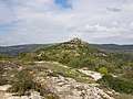
Tur Shimon rises abruptly 595 metres (1,952 ft) above sea level, conspicuous among the mountains as it rises up from the riverbed of the Nahal Sorek Nature Reserve in the form of a conical shaped mountain. The hilltop ruin is covered with brushwood and wild growth, ashlars, a partially standing wall of field stones, razed structures, and large rock-cut cisterns. The entire grounds are strewn with fragments of ancient pottery. Near the summit are six large water reservoirs, hewn in bedrock and plastered. On the northeastern slope of the ruin is a tunnel measuring c. 80 meters long, ending in a rock-hewn pit with niches resembling a columbarium (dovecote). On the southwest slope of the mountain are seen other traces of the town's material culture: a columbarium carved into the rock, a lime pit for burning limestone, a cistern and a wine press.
Access to the ruin is easiest on its south, southwestern quarter, on account of its steep declivities on all other sides which render it nearly inaccessible. At its top, there is a slight spur extending to its north, on which leveled field part of the village was formerly built. Together with the higher elevated part they comprise about 15 dunams (3.7 acres).[5] The mountain is built like a natural fortress. Below it to its southeast, in close proximity, is the ruin Khirbet Deir esh-Sheikh.
Lt. Conder, describing the terrain which he saw in July of 1881, wrote: "Riding down the great gorge which, under various names, runs down from near Gibeon to Beth Shemesh, we gradually ascended the southern slopes in the vicinity of the little ruined village of Deir esh Sheikh. Before us was a notable peaked knoll of Khurbet Sammûnieh, a conspicuous feature of the view, etc. …[the slopes] to the south were clothed with a dense brushwood of lentisk, arbutus, oak, hawthorn, cornel, kharûb, and other shrubs, while in the open glades the thyme, sage, citus (sic), and bellân carpetted (sic) the ledges with a thick fragrant undergrowth."[6] Lt. Conder goes on to surmise that the knoll of Kh. Sammunieh could have been Kirjath Jearim or Baal, or even Gibeah, seeing that the Camp of Dan was located directly to their west.[7]
In another description, where he describes more closely the pinnacle of the hill-top, without the lower spur in its northern quarter, he writes: "Khurbet Sammunieh. Square foundations and cisterns. On the hill-top is a foundation measuring 23 feet north and south, 16 feet east and west. It is filled with rubbish. A stone with a draft 3 inches wide was observed in it. About 60 or 70 yards to the south is a rock-hewn cistern, 12 feet deep, 15 feet square, etc., etc."[8] He names a well located to the south of the ruin, called Bir es Salib, cut in rock, 2½ feet square with a trough to the west, 5 feet by 10 feet.
Access
The main entrance to the site is accessed by foot-paths leading down into the Sorek valley from off regional highway 3866, near moshav Nes Harim. Conder and Kitchener who visited the valley in the late 19th century under the auspices of the Palestine Exploration Fund noted that a branch of an ancient Roman road passed alongside the mountain on its southern side, leading from Bethlehem to Beth-shemesh.[9]
Age of fortress
Some 45% of the sherds examined on the mountain proved to be from the Hellenistic period, while another 35% of sherds examined showed evidence of being from the early Roman period. The remaining sherds were shown to be from the Iron Age III (12%), and from the Byzantine era (8%).[10]
Gallery
 Tur Shimon - Kh. Sammunieh
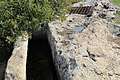 A well and trough beneath Tur Shimon
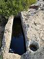 Well and trough
.jpg) Mouth of well beneath mountain
Mouth of well beneath mountain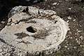 Stone of olive press beneath the mountain
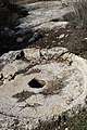 Olive press
.jpg) View from atop Tur Shimon
View from atop Tur Shimon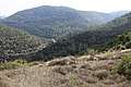 General view of region seen from Tur Shimon
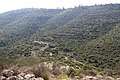 Valley to the south of Tur Shimon
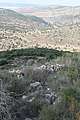 View from mountain looking west
 Brushwood growing atop Tur Shimon
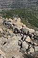 Remnant of old wall on Tur Shimon
 Wall at Tur Shimon
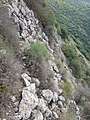 Steep declivity at Tur Shimon
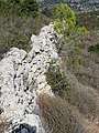 Wall of Tur Shimon
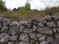 Stone wall (Tur Shimon)
_-_Stone_structures.jpg) Hurvat Tura, stone structures
Hurvat Tura, stone structures_in_Nahal_Sorek.jpg) View of Tur Shimon (Hurvat Tura)
View of Tur Shimon (Hurvat Tura)
References
| Wikimedia Commons has media related to Tur Shimon. |
- Being an exposition of the verse in Lamentations 2:2, "The Lord has swallowed up; He has not pitied".
- In the variant readings of this text in the Jerusalem Talmud, the word used for the content of these jars is marqoaʻ, explained by the commentary Etz Yosef as meaning "wine" (based on the Aramaic Targum in Jeremiah 13:12, and where such jars were used only for wine), but explained by the author of Sefer Arukh to mean "wicker baskets of shredded left-over bread to be given to the poor." Others have explained that the jars contained cakes of figs.
- editors, editors. The Midrash Rabba (Aicha Rabba 2:5); Jerusalem Talmud, Ta'anit 4:5.CS1 maint: extra text: authors list (link)
- Zissu (2004), pp. 14, 18
- Zissu (2004), p. 8
- Conder (1881), pp. 264–265
- Conder (1881), pp. 265–266
- Conder & Kitchener (1883), p. 124.
- Zissu (2004), p. 7
- Zissu (2004), p. 11
Bibliography
- Conder, C.R. (1881). "Lieutenants Conder´s report". Quarterly statement - Palestine Exploration Fund. 13: 247–281. (p. 264)
- Conder, C.R.; Kitchener, H.H. (1883). The Survey of Western Palestine: Memoirs of the Topography, Orography, Hydrography, and Archaeology. 3. London: Committee of the Palestine Exploration Fund.
- Zissu, Boaz (2004). "The Hellenistic Fortress at Ḥorvat Tura in the Jerusalem Hills and Identification of Tur Shimon". Cathedra: For the History of Eretz Israel and Its Yishuv. 112: 5–18. JSTOR 23407251. (Hebrew)</ref>
External links
- Tur Shimon (H. Tura) The Archaeological Survey of Israel
- Survey of Western Palestine, Map 17: IAA, Wikimedia commons
- Hurvat Tura (Tur Shimon) [Hebrew]
| Northern District |
|
|---|---|
| Central District |
|
| Southern District | |
| Eilat Region |
|
† Located in the Israeli-occupied territories | |