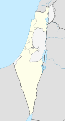
Districts of Israel
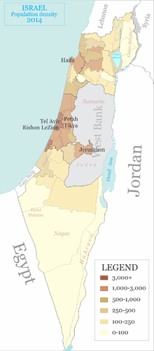
There are six main administrative districts of Israel, known in Hebrew as mehozot (מְחוֹזוֹת; singular: mahoz מָחוֹז) and Arabic as mintaqah and fifteen sub-districts known as nafot (נָפוֹת; singular: nafa נָפָה). Each sub-district is further divided into cities, municipalities, and regional councils it contains.
| Districts of Israel מְחוֹזוֹת יִשְׂרָאֵל (Hebrew) محافظات إسرائيل (Arabic) | |
|---|---|
| Category | Unitary State |
| Location | State of Israel |
| Number | 6 Districts |
| Populations | 966,700 (Haifa) – 2,024,500 (Central District) 1,350,000 (Tel Aviv District) |
| Areas | 190 km2 (72 sq mi) (Tel Aviv) – 14,190 km2 (5,477 sq mi) (Southern District) |
| Government | District government |
| Subdivisions | City council, Local council, Regional council |
The figures in this article are based on numbers from the Israeli Central Bureau of Statistics and so include all places under Israeli civilian rule including those Israeli-occupied territories where this is the case. Therefore, the Golan sub-district and its four natural regions are included in the number of sub-districts and natural regions even though it is not recognized by the United Nations or the international community as Israeli territory. Similarly, the population figure below for the Jerusalem District was calculated including East Jerusalem whose annexation by Israel is similarly not recognized by the United Nations and the international community. The Judea and Samaria Area, however, is not included in the number of districts and sub-districts as Israel has not applied its civilian jurisdiction in that part of the West Bank.
Jerusalem District
Jerusalem District (Hebrew: מְחוֹז יְרוּשָׁלַיִם, Mehoz Yerushalayim)
District capital: Jerusalem.[a]

Northern District
Northern District (Hebrew: מְחוֹז הַצָּפוּן, Mehoz HaTzafon)
District capital: Nazareth
- Tzfat (sub-district) – population: 116,000
- Kinneret (sub-district) – population: 114,000
- Yizre'el (sub-district) – population: 498,100
- Akko (sub-district) – population: 624,300
- Golan (sub-district)[b] – population: 48,800
Haifa District
Haifa District (Hebrew: מְחוֹז חֵיפָה, Mehoz Heifa)
District capital: Haifa
- Haifa (sub-district) – population: 571,100
- Hadera (sub-district) – population: 424,100
Central District
Central District (מְחוֹז הַמֶּרְכָּז, Mehoz HaMerkaz)
District capital: Ramla
- Sharon (sub-district) – population: 464,500
- Petah Tikva (sub-district) – population: 719,300
- Ramla (sub-district) – population: 338,800
- Rehovot (sub-district) – population: 593,300
Tel Aviv District
Tel Aviv District (Hebrew: מְחוֹז תֵּל־אָבִיב, Mehoz Tel Aviv)
District capital: Tel Aviv
Southern District
Southern District (Hebrew: מְחוֹז הַדָּרוֹם, Mehoz HaDarom)
District Capital: Beersheba
- Ashkelon (sub district) – population: 532,000
- Be'er Sheva (sub-district) – population: 712,200
Formerly Hof Aza Regional Council with a population of around 10,000 Israelis was part of this district, but the Israeli communities that constituted it were evacuated when the disengagement plan was implemented in the Gaza Strip. Currently only the Coordination and Liaison Administration operates there.
Judea and Samaria Area
Judea and Samaria Area (Hebrew: אֵזוֹר יְהוּדָה וְשׁוֹמְרוֹן, Ezor Yehuda VeShomron)
Largest city: Modi'in Illit
The name Judea and Samaria for this geographical area is based on terminology from the Hebrew and other sources relating to ancient Israel and Judah/Judea. The territory has been under Israeli control since the 1967 Six-Day War but not annexed by Israel, pending negotiations regarding its status. It is part of historic Israel, which leads to politically contentious issues. However, it is not recognized as part of the State of Israel by the UN and most nations.
Notes
- ^ a: This district includes areas captured in the 1967 Six-Day War and annexed to Israel in the Jerusalem Law.
- ^ b: Occupied in the 1967 Six-Day War and internationally unrecognized annexed by Israel's Golan Heights Law.
References
- "Localities and Population, by District, Sub-District, Religion and Population Group" (PDF). Israel Central Bureau of Statistics. 2017. p. 2. Retrieved December 24, 2017.
- Statistical Abstract – Geography (PDF) (Report) (in Hebrew). Israel Central Bureau of Statistics. 2016. p. 15 (PDF p. 9). Retrieved December 24, 2017.
External links
- Central Bureau of Statistics – detailed breakdown of each district, sub-district, and natural region.