Hadera
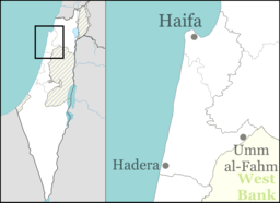
Hadera (Hebrew: חֲדֵרָה, Arabic: الخضيرة, romanized: al-Ḫuḍayrah[2]) is a city located in the Haifa District of Israel, in the northern Sharon region, approximately 45 kilometers (28 miles) from the major cities of Tel Aviv and Haifa. The city is located along 7 km (5 mi) of the Israeli Mediterranean Coastal Plain. The city's population includes a high proportion of immigrants arriving since 1990, notably from Ethiopia and the former Soviet Union. In 2018 it had a population of 95,683.[1]
Hadera
| |
|---|---|
| Hebrew transcription(s) | |
| • ISO 259 | Ḥdera |
 | |
 | |
 Hadera  Hadera | |
| Coordinates: 32°27′N 34°55′E | |
| Country | |
| District | |
| Founded | 1891 |
| Government | |
| • Type | City (from 1952) |
| • Mayor | Zvika Gendelman |
| Area | |
| • Total | 53,000 dunams (53 km2 or 20 sq mi) |
| Population (2018)[1] | |
| • Total | 95,683 |
| • Density | 1,800/km2 (4,700/sq mi) |
| Website | https://www.hadera.muni.il/ |
Hadera was established in 1891 as a farming colony by members of the Zionist group, Hovevei Zion, from Lithuania and Latvia. By 1948, it was a regional center with a population of 11,800. In 1952, Hadera was declared a city, with jurisdiction over an area of 53,000 dunams.[3]
History
Ottoman era
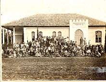
Hadera was founded on 24 January 1891, in the early days of modern Zionism by Jewish immigrants from Lithuania and Latvia on land purchased by Yehoshua Hankin, known as the Redeemer of the Valley.[3][4] The land was purchased from a Christian effendi, Selim Khuri. This was the largest purchase of land in Eretz Israel by a Zionist group, although the land was of low quality and mostly swampland. The only inhabitants prior to the purchase were a few families raising water buffaloes and selling reeds.[5] The village was named after Wadi al-Khudeira[6] (Arabic: وادي الخضيرة, lit. 'the valley of verdure'),[7] as the nearby section of Hadera Stream was known. Earlier, the whole Hadera Stream had been known as Nahr Akhdar (Arabic: نهر الأخضر, lit. 'green river').[8]
The Crusaders called the location Lictera – a corruption of the Arabic name, el-Khudeira. From the outset, attempts were made to pick instead a Hebrew name for the new settlement.[9] About half a year after it was founded, rabbi Ya'akov Goldman reported on an event in "the moshav of Hadere, that is, Hatzor".[10] The name Liktera was in preferential use by the British military during World War I.[11][12]
Baron Rothschild's surveyor, Yitzhak Goldhar, claimed that Hadera was founded on the site of the former town called Gedera of Caesarea (Hebrew: גדרה של קיסרין), as mentioned in Tosefta Shevi'it, ch. 7.[13] Benjamin Mazar preferred to locate ancient Gador, formerly known as Gedera by Caesaria, at Tell Ahḍar ("green hill"), later known as Tell esh Sheikh Ziraq[14] and currently as Tel Gador, on the coast south of Giv'at Olga.[15] Others say that the ancient Gadera should be identified with Umm Qais or with al-Judeira.
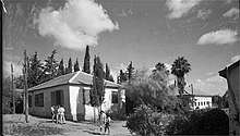
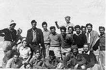
The first Jewish settlers lived in a building known as the Khan near Hadera's main synagogue. The population consisted of ten families and four guards. Baron Edmond de Rothschild provided funding for Egyptian laborers to drain the swamps.[16] Old tombstones in the local cemetery reveal that out of a population of 540, 210 died of malaria.[17] Therefore a Bible verse from the Psalms (Tehillim) was inscribed in the city's logo: "Those who sow in tears, will reap with songs of joy." (Ps 126:5) Hashomer guards kept watch over the fields to prevent incursions by the neighboring Bedouin.
By the early twentieth century, Hadera had become the regional economic center.[3] In 1913, the settlement included forty households, as well as fields and vineyards, stretching over 30,000 dunam.[13]
British Mandate
Land disputes in the area were resolved by the 1930s, and the population had grown to 2,002 in 1931.[4][5] Free schooling was introduced in the city in 1937 in all schools apart from the Histadrut school.[18]
 Hadera 1932 1:20,000
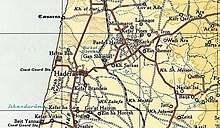 Hadera 1945 1:250,000
State of Israel
After the 1948 War, the north-western part of Hadera (including "Newe Chayyim") expanded on the land which had belonged to the depopulated Palestinian village of Arab al-Fuqara.[19]
Hadera's population increased dramatically in 1948 as immigrants flocked to the country. Most of the newcomers were from Europe, though 40 Yemenite families settled there, too.[17] In 1953, Israel's first paper mill opened in Hadera. Financed by investors from Israel, United States, Brazil and Australia, the mill was designed to meet all of Israel's paper needs.[20]New neighborhoods were built, among them Givat Olga on the coast, and Beit Eliezer in the east of the city. In 1964, Hadera was declared a city.[3]
In the 1990s, large numbers of Russian and Ethiopian immigrants settled in Hadera.[3][4] Hadera, considered a safe place by its inhabitants, was jolted by several acts of terrorism during the second intifada. On October 28, 2001, four civilians were killed when a terrorist opened fire on pedestrians at a bus stop.[21] A massacre of six civilians at a Bat Mitzvah occurred in early 2002.[22] A suicide bomber blew himself up at a falafel stand on October 26, 2005, killing seven civilians[23][24] and injuring 55, five in severe condition.[25] However, since the construction of the West Bank barrier, the frequency of such incidents has dropped drastically. During the second Lebanon War, on August 4, 2006, three rockets fired by Hezbollah hit Hadera. Hadera is 50 miles (80 km) south of the Lebanese border and marked the farthest point inside Israel hit by Hezbollah.[26]
In the 2000s, the city center was rejuvenated, a high-tech business park was constructed, and the world's largest desalination plant was built.[3][27] New neighborhoods are under construction in the underdeveloped northeastern part of the city, and plans are under way for a large park, shopping malls and hotels with a total of 1,800 rooms. The city is envisaged as a future vacation destination due to its closeness to the Galilee, beaches, and access to major highways.[28]
Geography and wildlife
Hadera is located on the Israeli Mediterranean coastal plain, 45 km (28 mi) north of Tel Aviv.[29] The city's jurisdiction covers 53,000 dunams (53.0 km2; 20.5 sq mi), making it the fourth largest city in the country. Nahal Hadera Park, a eucalyptus forest covering 1,300 dunams (1.3 km2; 0.5 sq mi) and Hasharon Park are located on the outskirts of Hadera.[3]
Hot water gushing from the Hadera power plant draws schools of hundreds of sandbar and dusky sharks every winter. Scientists are researching the rare phenomenon, which is unknown in the vicinity. It is speculated that the water, which is ten degrees warmer than the rest of the sea, may be the attraction.[30]
Transportation
Hadera lies along two main Israel Railways lines: the Coastal Line and the nowadays freight-only Eastern Line. The city's railway station is located in the west of the city and is on the Tel Aviv suburban line which runs between Binyamina and Ashkelon. The city center of Hadera is located near Israel's two main north-south highways; Highway 2, linking Tel Aviv to Haifa, and Highway 4.[3] This made Hadera an important junction for all coastal bus transportation after 1948 and into the 1950s.
Economy

Hadera Paper, established in 1953, continues to be a major employer in the city. The world's largest desalination plant of its type,[31] was inaugurated in December 2009.[3] Hadera is the location of the Orot Rabin Power Plant, Israel's largest power station.[32]
Demographics
According to the Israel Central Bureau of Statistics, as of October 2013, Hadera had a population of 91,634 which is growing at an annual rate of 1.2%.[33] As of 2003, the city had a population density of 1,516.6 per km2.[34] Of the city's population of 2013 of 91,634, approximately 23,407 were immigrants, many from Ethiopia.[34]
According to a census conducted in 1922 by the British Mandate authorities, Hadera had a population of 540 inhabitants, consisting of 450 Jews, 89 Muslims and 1 Christian.[35] Hadera has grown steadily since 1948, when the city had a population of 11,800. In 1955, the population almost doubled to 22,500. In 1961 it rose to 25,600, 1972 to 32,200, and 1983, to 38,700.[34]
The median age in Hadera is 32.8, with 23,200 people 19 years of age or younger, 12.1% between 20 and 29, 14,100 between 30 and 44, 17,600 from 45 to 64, and 9,700, 65 or older.[36] As of 2007, there were 37,500 males and 39,200 females.[36]
In 2001, the ethnic makeup was 99.2% Jewish and other non-Arab, with no significant Arab population. In 2000, there were 27,920 salaried workers and 1,819 self-employed. The mean monthly wage in 2000 for a salaried worker was ILS 5,135, a real change of 8.0% over the course of 2000. Salaried males had a mean monthly wage of ILS 6,607 (a real change of 9.0%) compared with ILS 3,598 for females (a real change of 3.1%). The mean income for the self-employed was 6,584. A total of 1,752 people received unemployment benefits and 6,753 received income supplements.
Education
In 2001, there were 15,622 students studying at 42 schools (24 elementary schools with 7,933 students, and 21 high schools with 7,689 students). A total of 57.5% of 12th graders were entitled to a matriculation certificate.
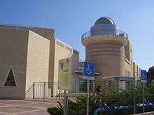
The Democratic School of Hadera, which opened in 1987, was the first of its kind in Israel. The Technoda, an educational center for science and technology equipped with a state-of-the-art telescope and planetarium, is located in Hadera's Givat Olga neighborhood.[37]
Medical facilities
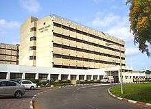
Hadera is served by the Hillel Yaffe Medical Center.
Neighborhoods
Neighborhoods of Hadera include Givat Olga,[38] Beit Eliezer, Kfar Brandeis, Haotzar, Hephzibah, Neve Haim, Nissan, Ephraim, Bilu, Klarin, Nahaliel, Shimshon, Shlomo, Pe'er, Bialik, Beitar and The Park.
Sports
Hadera is home to three current football clubs: Hapoel Hadera, which currently plays in Israeli Premier League after being promoted at the end of 2017/18 season. Beitar Hadera (playing in Liga Gimel Shomron) and the women's football club Maccabi Kishronot Hadera (playing in Ligat Nashim Rishona). In the past the city was also home to Maccabi Hadera, Hapoel Nahliel and Hapoel Beit Eliezer.
The city is also represented in the Israeli Beach Soccer League. Its team, Hapoel Hadera, won the championship (under its previous name, Hadera's Princes) in 2008.[39]
In Basketball, Maccabi Hadera's women's basketball team plays in second tier Liga Leumit, while the club's Maccabi Hadera men's basketball team plays in third tier Liga Artzit.
Notable residents
- Eldad Amir (born 1961), Olympic competitive sailor
- Shimon Baadani (born 1928), Sephardi rabbi, rosh kollel, and senior leader of the Shas party
- Avshalom Feinberg
- Shlomo Gronich, musician
- Orna Grumberg, computer scientist
- Tzuri Gueta, designer
- Sarit Hadad, singer
- Moshe Kahlon (Givat Olga neighborhood), politician
- Yoel Sela (born 1951), Olympic competitive sailor
- Baruch Shmailov (born 1994), judoka
- Alon Stein (born 1978), basketball player and coach
Twin towns — sister cities
See also
References
- "Population in the Localities 2018" (XLS). Israel Central Bureau of Statistics. 25 August 2019. Retrieved 26 August 2019.
- "دائرة الأجراء - الخضيرة" [Execution Chamber, Hadera] (in Arabic). Law Enforcement and Collection System Authority.
- "New Urbanism, Israeli Style". Haaretz. Retrieved 2008-11-28.
- "Hadera". Jewish Virtual Library. Retrieved 2008-10-25.
- Avneri, Aryeh L. (1984). The Claim of Dispossession: Jewish Land-Settlement and the Arabs, 1878-1948. Transaction Publishers. p. 93. ISBN 0-87855-964-7. Retrieved 2008-10-25.
- Yehoshua Levinzon (1959). HaSharon (PDF). Tel Aviv: Ma'arachot.
חדרה נקראה על שם הנחל הסמוך, אשר קטע ממנו נקרא בערבית ואדי חודֵירה - הנחל הירקרק.
- The Survey of Western Palestine: A General Index. 1. London: Committee of the Palestine Exploration Fund. 1838. p. 155.
- Trelawney Saunders (1881). An Introduction to the Survey of Western Palestine: its Waterways, Plains, & Highlands. London: Richard Bentley and Son. pp. 24, 32–33.
- Irit Zaharoni (1990). Israel, Roots & Routes: A Nation Living in Its Landscape. Ministry of Defense (Israel). p. 288.
- Ya'akov Goldman (1891) [Tammuz 5651 (July-Aug)]. "שאר ישוב". In Ze'ev Yavetz (ed.). מירושלם [Mirushalayim]. 1. Warsaw: Schuldberg Brothers. p. 13).
לנחלת חדֶרי (היא חצור) כבר נעשתה "מֻצְדַקְיָה"
- Through Palestine with the 20th Machine Gun Squadron. London. 1920. p. 113.
the Brigade, winding its way through the groves, came out into the pretty little Village of Liktera (a Jewish settlement called by them Hudeira)
- John D. Grainger (2013). The Battle for Syria, 1918-1920. Boydell Press. p. 133. ISBN 9781843838036.
At Liktera (also called Hadera) on the Nahr el-Mafjir, another five miles on, the division halted
- Yitzhak Goldhar (1913). "4. הימים שמקיפין את ארץ ישראל.". אדמת קדש [Admat Kodesh]. Frankfurt am Main: Jiddisch Literarische Gesellschaft. pp. 83–84.
כמעט באמצע המרחק שבין עין טב ולבין קיסרין במרחק 2½ קילומיטר למערבה של החורבה הנקראת תל דרור היא עיר דאר שבחלק מנשה (ב) נוסדה (בשנת התרנ"א) מושבה של יהודים שקראו לה חֶידֶירֶה ואולם גדרה שמה לראשונה כי המושבה הזאת נבנתה במקום אשר לפנים היתה עיר גדרה של קיסרין הנזכרת בתוספתא שביעית פ"ז: ושאר כל ארצות אוכלין עד שיכלו מבית אל ומגדרה של קיסרין. [...] בגדרה של קיסרין יושבים כעת ארבעים בעלי בתים ולהם שדות וכרמים ובתים טובים. כל שטח אדמתם עולה בערך שלשים אלף דולאם.
- Archaeological Survey of Israel
- B. Maisler (1934). "Der Distrikt Śrq in den Samarischen Ostraka". The Journal of the Palestine Oriental Society: 96–100.
Für (A)gdōr = Gedera kommt m.E. kein anderer Punkt so sehr in Betracht, als Tell Ahḍar an der Meeresküste, kaum 7 km. südlich von Caesarea. Tell Ahḍar ist eine ausgedehnte Ruinenstätte, die zahlreiche antike Säulen und sonstige Reste aus römischer Zeit aufweist.
- Gilbert, Martin (1998). Israel, a History. Morrow. p. 9. ISBN 0-688-12362-7.
- Winter, Dave (1999). Israel Handbook. Footprint Travel Guides. p. 532. ISBN 1-900949-48-2. Retrieved 2008-10-25.
- Sternhell, Zeev (1999). The Founding Myths of Israel: Nationalism, Socialism, and the Making of the Jewish State. Princeton University Press. p. 255. ISBN 0-691-00967-8. Retrieved 2008-10-25.
- Khalidi, W. (1992). All That Remains: The Palestinian Villages Occupied and Depopulated by Israel in 1948. Washington D.C.: Institute for Palestine Studies. p. 144. ISBN 0-88728-224-5.
- "First Paper Mill Opened in Israel; Plant at Hadera is Expected to Help Nation Cut Currency Gap $1,000,000 a Year". New York Times. 1953-12-18. Retrieved 2008-10-25.
- Victims of Palestinian Violence and Terrorism since September 2000
- "Bat mitzvah massacre in Israel leaves seven dead". The Independent. 2002-01-18. Retrieved 2020-06-07.
- "Larissa Grishchenko". GxMSDev.
- "Woman injured in Hadera terror attack dies 4 years later". ynet.
- "Suicide bomber rocks Hadera market". Haaretz.com. 27 October 2005.
- "For first time: Hizbullah targets Hadera area". Ynet News. 2006-08-04. Retrieved 2008-11-30.
- Rabinovitch, Ari. "Israel opens largest desalination plant of its kind". Reuters. Retrieved 2013-03-26.
- No Longer a Backwater, Hadera Plans Big Push - Inside Israel - News - Israel National News
- "Telfed takes on next target: Hadera". Haaretz.com. 1 May 2009.
- Sharks drawn to warm waters by Israeli coastal power plant
- Rinat, Zafrir (2008-04-02). "Where will the water go? - Haaretz Daily Newspaper | Israel News". Haaretz.com. Retrieved 2011-09-16.
- Paz, Shelly (2007-03-01). "Greenpeace protests at Hadera power plant | Israel | Jerusalem Post". Jpost.com. Retrieved 2009-05-05.
- "Table 3 - Population of Localities Numbering Above 2,000 Residents" (PDF). Israel Central Bureau of Statistics. 2010-06-30. Retrieved 2010-10-30.
- "Population and Density per Km² in Localities Numbering Above 5,000 Residents" (PDF). 55th Statistical Yearbook. Israel Central Bureau of Statistics. 2003. Archived from the original (PDF) on 2008-02-29. Retrieved 2008-03-15.
- "Statistical Abstract of Israel 2008". Israel Central Bureau of Statistics. Archived from the original on 2008-12-18. Retrieved 2008-11-29.
- "NJ Jewish News on-line - Reach for the stars". njjewishnews.com. Archived from the original on 2012-12-23. Retrieved 2019-01-06.
- "Women on the Map - Olga Hankin". women.org.il. Archived from the original on 2017-04-25. Retrieved 2019-01-06.
- Hadera's Princes are the Champions of Bank Yahav Beach Soccer League for the Year 2008 netanya.muni.il (in Hebrew)
- "Hadera - Identity Card". forum15.org.il. Forum 15. Retrieved 2020-02-25.
- "New Sister City Relationship". embassies.gov.il. Consulate General of Israel in Houston. 2015-05-20. Retrieved 2020-02-25.
- "Cidade vai ter geminação com Ribeira Grande de Santiago (Cabo Verde)". mediotejo.net (in Portuguese). Mediotejo. 2019-09-18. Retrieved 2020-02-25.
External links
| Wikimedia Commons has media related to Hadera. |
- Official website (in Hebrew)
| Cities | ||
|---|---|---|
| Local councils | ||
| Regional councils | ||
| See also |
| |
| Authority control |
|
|---|