Glenbrook, New South Wales
Glenbrook is a suburb of the Lower Blue Mountains of New South Wales, Australia. It is located 70 kilometres west of Sydney in the local government area of the City of Blue Mountains. At the 2016 Australian census Glenbrook had a population of 5,051 people.[1]
| Glenbrook New South Wales | |||||||||||||||
|---|---|---|---|---|---|---|---|---|---|---|---|---|---|---|---|
 Glenbrook railway station | |||||||||||||||
Glenbrook | |||||||||||||||
| Coordinates | 33°46′00″S 150°37′10″E | ||||||||||||||
| Population | 5,051 (2016 census)[1] | ||||||||||||||
| Postcode(s) | 2773 | ||||||||||||||
| Location | 70 km (43 mi) west of Sydney | ||||||||||||||
| LGA(s) | City of Blue Mountains | ||||||||||||||
| State electorate(s) | Penrith | ||||||||||||||
| Federal Division(s) | Macquarie | ||||||||||||||
| |||||||||||||||
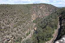
Glenbrook lies between Lapstone and Blaxland at an elevation of 163 m (535 ft) and is approximately a 50-minute drive from Sydney. It plays host to trendy cafes and boutiques, while offering various tourist attractions, including weekend markets, recreational opportunities and native flora and fauna.
The suburb takes its name from Glenbrook Creek, which is on the southern side of the village and must be crossed to enter the Blue Mountains National Park. Glenbrook retains many historical homes and buildings throughout the village, although most homes are occupied and not open to the public.
History
Blaxland, Wentworth and Lawson reached Glenbrook area and Lagoon on their trek across the Blue Mountains on 12 May 1813 and described it as "a large lagoon of good water full of very coarse rushes".[2]
In 1815, William Cox constructed the first road over the Blue Mountains with a gang of convicts and the Glenbrook area became an important stopping point after a storeroom was built near the lagoon. Governor Macquarie also built a military depot near the lagoon to monitor traffic on the newly built road.[2]
After years of use, Cox's road up Lapstone Hill ran into a few problems. It was very steep in sections and in rain became slippery. A new road and stone bridge was built and opened to traffic in 1833 "The Western Road", at what is today Mitchell's Pass, planned and built by Thomas Livingstone Mitchell. The Stone Bridge, Lennox Bridge completed in 1833 and designed by Scottish stonemason David Lennox is the oldest surviving stone bridge on the Australian mainland.
Glenbrook became a town in the 1870s as a result of the arrival of the railway. In 1867 a zigzag railway was built up the Lapstone Hill and on to Weatherboard "Wentworth Falls". A siding was also built at Glenbrook "Wascoe's Siding", named after an Inn from the local area, water from Glenbrook Lagoon was piped to supply the trains after traversing the Lapstone ZigZag. This Wascoe Siding became a passenger station in 1877. In 1878, Sir Alfred Stephen, Chief Justice and Privy Councillor, decided to give the station a proper name and called it Brookdale, but later it was officially changed to Glenbrook in 1879, named after the nearby creek and Gorge.[2] Glenbrook, which Sir John Jamison thought came from Regents Glen. A village sprung up near the station and was officially proclaimed Glenbrook, six years later.
The Lapstone ZigZag opened in 1867, a part of the ascent of Lapstone Hill on a gradient of 1 in 30–33, which was built up the side of the range with comparatively light earthwork, although it includes the substantial seven-span sandstone Knapsack Viaduct. This was later widened to carry the old Great Western Highway, and it is now part of a walking trail on the old railway/highway alignment, including a memorial to the engineer in charge of the construction of the Blue Mountains line and many other early railways, John Whitton.
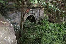
In 1892 the first deviation of the railway up the Lapstone Hill, bypassed the Lapstone Zig Zag altogether. A tunnel was built through the hill to the Old Glenbrook station (subsequently dismantled). The 1892 Glenbrook Tunnel ran into trouble with water seeping from the nearby creek and the steep gradient making the climb hard for most trains, often getting stuck in the tunnel.[3]
In 1913 the second deviation of the railway line up Lapstone Hill was completed with a new double-tracked 1913 tunnel at the Bluff Point. The old 1892 Glenbrook Tunnel was subsequently closed. As a result of the new line, the Old Glenbrook station was relocated from next to the Great Western Highway to its current location next to the village of Glenbroook at the end of Ross Street, and was officially opened 11 May 1913.[4]
The abandoned 1892 Glenbrook Tunnel has been used to store mustard gas during World War II, and grow mushrooms in recent times. The eastern entrance can be still seen from a walking track at Lapstone.[5][6][7]
On 28 January 1941, an Avro Anson of No. 1 Air Navigation School, Parkes crashed near Glenbrook during a medical evacuation flight from Parkes to the Sydney Airport.[8] All five crew members were killed.[8]
In 1999, the town was associated with the Glenbrook train disaster.
Since 2005, the suburb has been the home of The Australian Gnome Convention organised by the Rotary Club of Lower Blue Mountains and held on Australia Day each year. Owners of garden gnomes display their garden decorations and compete for various awards to raise funds for charities.[9]
Heritage listings
New South Wales State Heritage Register
Glenbrook has a number of heritage-listed sites, including the following items listed on the New South Wales State Heritage Register:
- Blue Mountains National Park: Blue Mountains walking tracks[10]
- 15-17 Great Western Highway: Knapsack Gully Viaduct, 1865[11]
- 78 Great Western Highway: Glenbrook railway residence[12]
- Great Western Highway: 1892 Glenbrook Tunnel[3]
- Mitchells Pass: Lennox Bridge, Glenbrook – the oldest surviving stone arch bridge in mainland Australia[13]
City of Blue Mountains local government heritage register
Ilford_House_Wascoe_Street_Glenbrook-1.jpg)
Bonnie_Doone_Moore_Street_Glenbrook.jpg)
Glenbrook has a number of heritage-listed sites, including the following items listed on the City of Blue Mountains local government heritage register, as recorded in the New South Wales Heritage Database:[14]
- Blue Mountains National Park: Red Hand Cave
- 67 Brook Road: The Bluff
- Burfitt Parade: Glenbrook railway station
- 2 Cross Street: House
- 15 Euroka Road: Thurso
- 26 Explorers Road: House
- 175 Explorers Road: The Spurline
- Great Western Highway: Glenbrook Deviation (1913)
- 2 Great Western Highway: Gatekeeper's Cottage No 1
- 2 Great Western Highway: Whitton Memorial
- 15 Great Western Highway: Glenbrook Deviation (1892)
- 15-17 Great Western Highway: Lapstone Zig Zag
- 29 Great Western Highway: Briarcliffe (now RAAF Base Glenbrook)
- 29 Great Western Highway: Former Lapstone Hotel (now RAAF Base Glenbrook)
- 41 Great Western Highway: Blaxland, Wentworth and Lawson Memorial
- 41 Great Western Highway: Glenbrook Native Plant Reserve
- 41 Great Western Highway: Original Glenbrook Railway Sign and Monument
- 12 Hare Street: Glenbrook School of Music
- Off Knapsack Street: Lucasville Station
- 15-19 Lagoon Drive: Glenbrook Lagoon
- 33 Lucasville Road: Phoenix Palm Group
- 37 Lucasville Road: Kalamunda
- 2 Mann Street: House
- 9 Mann Street: House
- 33 Moore Street: Bonnie Doone
- 6 Nepean Gardens Place: Ulinbawn
- 4 Park Street: Serendip
- 6 Park Street: Glenbrook Cottage
- 10 Park Street: Glenbrook Primary School
- 10 Park Street: The Warruwii Centre - Building B00A
- 20-30 Park Street: Glenbrook Park
- 23-29 Park Street: Green Real Estate
- 41 Park Street: Briar Hill
- 2 Ross Street: Horse Trough
- 20 Ross Street: Glenbrook Garden Centre
- 6 Raymond Street: House
- 8 Raymond Street: House
- 6 Wascoe Street: House
- 8 Wascoe Street: Ilford, house and garden
- 9 Waters Road: Arcadia
Population
In the 2016 Census, there were 5,051 people in Glenbrook. 82.0% of people were born in Australia. The next most common country of birth was England at 5.4%. 90.9% of people spoke only English at home. The most common responses for religion were No Religion 31.5%, Catholic 24.5% and Anglican 18.7%.[1]
Transport
Glenbrook railway station is on the Blue Mountains Line of the NSW TrainLink intercity network. Also, the Great Western Highway passes through the town.
Landmarks
- Two fire brigade stations, one which falls under the jurisdiction of the volunteer Rural Fire Service as well as a 'retained' New South Wales Fire Brigades station (station 301)
- Glenbrook Cinema
- Glenbrook Cottage (1916), Park Street (heritage-listed)
- Glenbrook Oval
- Glenbrook Park (1884) and stone gate are heritage-listed
- Glenbrook Stone Suburb Staircase
- Glenbrook Swim Centre
- Knapsack Oval
- Mount Sion Park
- Sir Douglas Smith Park
- Wascoe Siding Train Park
- Whitton Park
Gallery
School_of_Music_Hare_Street_Glenbrook-2.jpg) Former School of Music, Hare Street
Former School of Music, Hare StreetGlenbrook_Public_School.jpg) Glenbrook Public School
Glenbrook Public SchoolSt_Andrews_Uniting_Church_Glenbrook.jpg) St Andrew's Uniting Church
St Andrew's Uniting ChurchView_from_Chalmers_Lookout_south_east_Glenbrook.jpg) Chalmers Lookout, Glenbrook
Chalmers Lookout, GlenbrookRoss_Street_Glenbrook-2.jpg) Ross Street, Glenbrook Village Shopping Area
Ross Street, Glenbrook Village Shopping Area Kangaroos at Euroka Camp Area, Blue Mountains National Park Glenbrook Entrance.
 Lennox Bridge, 1833
 Blue Mountains suburbs staircase
Recreation
- Jellybean Pool/Glenbrook Gorge/Blue Pool, entered via the national park (generally free entry on weekdays)
- Endpoint of the Oaks Firetrail, a popular off-road bike route between Woodford and Glenbrook
- Camping at Euroka Clearing where kangaroos can be seen at all times of the day and year (especially summer)
- Bushwalking: Via Euroka Clearing to the Nepean River, Via Evans Track to Warragamba Dam
- Glenbrook Cinema (one of three in the Blue Mountains)[15]
- Glenbrook Swimming Centre (also considered to be in Blaxland)
- The Glenbrook Swimming Club
- The Lapstone/Glenbrook Netball Club
- The Glenbrook/Blaxland Cricket Club
- The Blue Mountains Football Club
- The Glenbrook Panthers Bowling Club
See also
- List of Blue Mountains articles
References
- Australian Bureau of Statistics (27 June 2017). "Glenbrook (State Suburb)". 2016 Census QuickStats. Retrieved 31 January 2019.


- "Glenbrook, NSW". Aussie Towns. Retrieved 1 March 2019.
- "Glenbrook Railway and World War Two Mustard Gas Storage Tunnel". New South Wales State Heritage Register. Office of Environment and Heritage. H01861. Retrieved 18 May 2018.
- "Glenbrook Railway Station Group". New South Wales State Heritage Register. Office of Environment and Heritage.
- Walker, Frank (20 January 2008). "Deadly chemicals hidden in war cache". The Sydney Morning Herald. Retrieved 27 September 2018.
- Plunkett, Geoff. "Depots: Glenbrook funnel". Chemical Warfare in Australia. Department of Defence. Retrieved 27 September 2018.
- Plunkett, Geoff. "Home page". Chemical Warfare in Australia. Department of Defence. Retrieved 27 September 2018.
- Dunn, Peter. "CRASH OF AN AVRO ANSON AT GLENBROOK, NSW ON 28 JANUARY 1941". www.ozatwar.com. Retrieved 15 January 2013.
- "Australian Gnome Convention".
- "Blue Mountains Walking tracks". New South Wales State Heritage Register. Office of Environment and Heritage. H00980. Retrieved 18 May 2018.
- "Knapsack Viaduct, Lapstone". New South Wales Heritage Database. Office of Environment and Heritage.
- "Glenbrook Railway Residence". New South Wales State Heritage Register. Office of Environment and Heritage. H00713. Retrieved 18 May 2018.
- "Lennox Bridge". New South Wales State Heritage Register. Office of Environment and Heritage. H00024. Retrieved 18 May 2018.
- "Search: Glenbrook". New South Wales Heritage Database. Office of Environment and Heritage. Retrieved 17 May 2020.
- Glenbrook Cinema – Official Website
- Aston, N. (1988) Rails, Roads & Ridges: History of Lapstone Hill-Glenbrook. Glenbrook Public School Centenary Committee. ISBN 0-9588163-1-X
External links
| Wikivoyage has a travel guide for Glenbrook (New South Wales). |
- Blue Mountains National Park – Glenbrook – attractions and walks
- More Glenbrook Information
- Glenbrook Chamber of Commerce
| Wikimedia Commons has media related to Glenbrook, New South Wales. |