List of earthquakes in Indonesia
This is an incomplete list of more recent recorded major earthquakes that have occurred within the boundaries of Indonesia—as indicated by the geology of the region, and the volcanic activity—much large numbers of earthquakes of smaller magnitude occur very regularly due to the meeting of major tectonic plates in the region. Based on the records of the USGS, Indonesia has had more than 150 earthquakes with magnitude > 7 in the period 1901–2017.
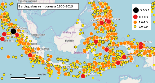
Map of earthquakes in Indonesia 1900-2019
Earthquakes
| Date | Region | Mag. | MMI | Fatalities | Injuries | Comments | |
|---|---|---|---|---|---|---|---|
| 2019-11-04 | Molucca Sea | 7.1 Mw | VII | 1 | 3 | [1] | |
| 2019-11-12 | Maluku | 5.0 Mw | IV | 2 | 9 | Aftershock. | [2] |
| 2019-09-25 | Maluku | 6.5 Mw | VII | 41 | 1,578 | Landslides. | [3] |
| 2019-08-02 | Java | 6.9 Mw | VI | 8 | 8 | [4] | |
| 2019-07-14 | North Maluku | 7.2 Mw | VIII | 14 | 129 | [5] | |
| 2019-04-12 | Sulawesi | 6.8 Mw | VI | 1 | [6] | ||
| 2019-03-17 | Lombok | 5.5 Mw | V | 6 | 182 | [7] | |
| 2018-11-14 | Sulawesi | 5.6 Mw | VII | 7 | 6 | Landslides. | [8] |
| 2018-10-10 | Java | 6.0 Mw | V | 4 | 36 | [9] | |
| 2018-09-28 | Sulawesi | 7.5 Mw | IX | 4,340 | 10,679 | Major tsunami (up to 7m), more than 600 people missing. | [10] |
| 2018-08-19 | Lombok | 6.9 Mw | VII | 14 | 24 | Fatalities also in Sumbawa. | [11] |
| 2018-08-19 | Lombok | 6.3 Mw | VII | 2 | 3 | Aftershock. | [12] |
| 2018-08-09 | Lombok | 5.9 Mw | VII | 6 | 24 | Aftershock. | [13] |
| 2018-08-05 | Lombok | 6.9 Mw | VIII | 513 | 1,353 | Widespread damage. | [14] |
| 2018-07-29 | Lombok | 6.4 Mw | VIII | 20 | 401 | Foreshock. | [15][16] |
| 2018-07-21 | Sumatra | 5.2 MW | 1 | 2 | [17] | ||
| 2018-04-18 | Java | 4.5 MW | 3 | 21 | Building damage in Kalibening District. | [18] | |
| 2018-01-23 | Java | 6.0 MW | V | 2 | 41 | ||
| 2017-12-15 | Java | 6.5 Mw | VII | 4 | 36 | ||
| 2017-10-31 | Ambon | 6.3 Mw | VII | 1 | [19] | ||
| 2016-12-07 | Sumatra | 6.5 Mw | IX | 104 | 1,273 | Heavy damage in Aceh region. | |
| 2016-03-02 | Sumatra | 7.8 Mw | III | ||||
| 2015-07-28 | Papua | 7.0 Mw | VII | 1 | Buildings damaged or destroyed. | [20] | |
| 2013-07-02 | Sumatra | 6.1 Mw | 43 | 276 | [21] | ||
| 2012-04-11 | Wharton Basin | 8.2 Mw | VI | Doublet | |||
| 2012-04-11 | Wharton Basin | 8.6 Mw | VII | 10 | 12 | Doublet | |
| 2011-09-05 | Sumatra | 6.7 Mw | 10 | [22] | |||
| 2010-10-25 | Sumatra | 7.8 Mw | VII | 408 | Tsunami (local), hundreds missing. | ||
| 2010-06-16 | Papua | 7.0 Mw | VII | 17 | |||
| 2010-05-09 | Sumatra | 7.2 Mw | V | ||||
| 2010-04-06 | Sumatra | 7.8 Mw | VIII | 62 | |||
| 2009-10-01 | Sumatra | 6.6 Mw | VII | 3 | Severe damage. | [23] | |
| 2009-09-30 | Sumatra | 7.6 Mw | VII | 1,115 | 2,902 | Tsunami (local) | |
| 2009-09-02 | Java | 7.3 Mw | VII | 79 | 1,250 | Tsunami (local) | [24] |
| 2009-02-12 | Talaud | 7.2 Mw | VI | 64 | |||
| 2009-01-04 | West Papua | 7.4 Mw | VII | Doublet | |||
| 2009-01-04 | West Papua | 7.7 Mw | VI | 4 | 50+ | Doublet / tsunami (local) | |
| 2008-11-16 | Sulawesi | 7.3 Mw | VII | 4 | 59 | ||
| 2008-02-20 | Simeulue | 7.4 Mw | 3 | [25] | |||
| 2007-09-12 | Sumatra | 8.4 Mw | 23 | 88 | |||
| 2007-03-06 | Sumatra | 6.3 Mw | VI | ||||
| 2007-03-06 | Sumatra | 6.4 Mw | VIII | 68 | 460 | ||
| 2007-01-21 | Molucca Sea | 7.5 Mw | VI | 4 | [26] | ||
| 2006-12-18 | Sumatra | 5.8 Mw | VI | 7 | [27] | ||
| 2006-07-17 | Java | 7.7 Mw | IV | 668 | 9,299 | Tsunami (regional) | |
| 2006-05-26 | Java | 6.4 Mw | IX | 5,749 | 38,568 | Extreme damage | |
| 2006-03-14 | Seram | 6.7 Mw | VI | 4 | Tsunami (local) (7 m (23 ft)) | [28] | |
| 2005-03-28 | Sumatra | 8.6 Mw | VI | 1,314 | 1,146 | ||
| 2004-12-26 | Sumatra–Andaman | 9.1–9.3 Mw | IX | 227,898 | Tsunami (basin wide), 167,540 fatalities in Indonesia | ||
| 2004-11-26 | Papua | 7.1 Mw | VIII | 32 | 130–213 | ||
| 2004-11-11 | Alor | 7.5 Mw | VIII | 34 | 400 | Severe damage | [29] |
| 2004-02-07 | Western New Guinea | 7.3 Mw | Doublet / Damage at Nabire | [30] | |||
| 2004-02-05 | Western New Guinea | 7.0 Mw | VI | 37 | Doublet | [31] | |
| 2004-01-01 | Bali | 5.8 Mw | VI | 1 | 29 | Several thousand buildings damaged | NGDC |
| 2003-05-26 | Halmahera | 7.0 Mw | 1 | [32] | |||
| 2002-11-02 | Sumatra | 7.3 Mw | VI | 3 | 65 | ||
| 2002-10-10 | Western New Guinea | 7.6 Mw | 8 | Tsunami (local) | [33] | ||
| 2000-06-04 | Sumatra | 7.9 Mw | VI | 103 | 2,174 | ||
| 2000-05-04 | Sulawesi | 7.6 Mw | VII | 46 | 264 | Tsunami (local) | NGDC |
| 1996-02-17 | Biak | 8.1 Mw | VIII | 166 | 423 | ||
| 1996-01-01 | Sulawesi | 7.9 Mw | 8 | Tsunami (local) | [34] | ||
| 1995-10-06 | Sumatra | 6.8 Mw | 84 | 1868 | Extreme damage | NGDC | |
| 1994-06-03 | Java | 7.8 Mw | IV | 250 | Tsunami (local) | ||
| 1994-02-15 | Sumatra | 7.0 Mw | VII | 207 | 2,000+ | ||
| 1992-12-11 | Flores | 7.8 Mw | IX–X | 2,500 | 500 | Tsunami (local) | |
| 1989-08-01 | West Papua | 6.0 Mw | VIII | 120 | 125 | ||
| 1984-11-17 | Sumatra | 7.2 Mw | VII | 1 | |||
| 1982-12-25 | Flores | 5.9 Mw | VI | 13 | 390 | ||
| 1981-01-19 | Papua | 6.8 ML | 305 | Hundreds missing | |||
| 1979-12-18 | Bali | 6.3 Ms | VIII | 27 | 200+ | ||
| 1977-08-19 | Sumba | 8.3 Mw | 180 | 1,100 | Tsunami (local) | ||
| 1976-07-15 | Bali | 6.5 Ms | IX | 573 | 4,750 | ||
| 1976-06-25 | Papua | 7.1 Mw | X | 422 | Landslides, thousands missing | ||
| 1968-10-19 | Sulawesi | 7.4 ML | 213 | ||||
| 1965-01-24 | Sanana | 8.2 Mw | 71 | ||||
| 1943-06-09 | Sumatra | 7.5 Mw | Doublet | ||||
| 1943-07-23 | Java | 7.0 Mw | VIII | 213 | 2,096 | Severe damage | NGDC |
| 1943-06-08 | Sumatra | 7.2 Mw | Doublet | ||||
| 1938-02-01 | Banda Sea | 8.4 Mw | VII | Tsunami (local) | |||
| 1935-12-28 | Sumatra | 7.7 Mw | VIII | Tsunami (local) | |||
| 1917-01-20 | Bali | 6.6 Ms | IX | 1,500 | Landslides | ||
| 1907-01-04 | Sumatra | 8.2–8.4 Mw | VIII | 2,188 | Tsunami (regional) | ||
| 1899-09-30 | Seram | 7.8 Ms | 3,864 | Tsunami (local) | |||
| 1867-06-10 | Java | IX | 5 | Severe damage | NGDC | ||
| 1861-02-16 | Sumatra | 8.5 Mw | 2,000+ | ||||
| 1852-11-25 | Banda Sea | 8.3 Ms | IX | Severe damage / tsunami (regional) | NGDC | ||
| 1834-10-10 | Java | 7.0 Mw | VIII | ||||
| 1833-11-25 | Sumatra | 8.8–9.2 Mw | Numerous | Tsunami (local) | |||
| 1815-11-22 | Bali | 7.0 Ms | 10,253 | Tsunami | NGDC | ||
| 1797-02-10 | Sumatra | 8.4 Mw | Numerous | Tsunami (local) | |||
| 1780-01-22 | Java | 8.5 Mw | X-XI | ||||
| 1699-01-05 | Batavia (Jakarta) | 28 | 49 buildings collapsed | [35] | |||
| 1674-02-17 | Ambon–Seram | 6.8 Ms | 86 | 135 | Severe damage / tsunami | NGDC | |
| 1629-08-01 | Banda Sea | 8.2–8.8 Ms | Tsunami (regional) | ||||
| Note: The inclusion criteria for adding events are based on WikiProject Earthquakes' notability guideline that was developed for stand alone articles. The principles described also apply to lists. In summary, only damaging, injurious, or deadly events should be recorded. | |||||||
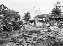
Earthquake damage in Ambon, 1898
See also
References
- "M 7.1 - 138km E of Bitung, Indonesia". earthquake.usgs.gov. Retrieved 2019-11-17.
- Siwalimanews (2019-11-14). "Dampak Gempa Ambon, 2 Meninggal, 9 Luka". Siwalima (in Indonesian). Archived from the original on 2019-11-14. Retrieved 2019-11-15.
- "M 6.5 - 10km S of Kairatu, Indonesia". earthquake.usgs.gov. Retrieved 2019-09-26.
- "M 6.9 - 102km WSW of Tugu Hilir, Indonesia". earthquake.usgs.gov. Retrieved 2019-02-08.
- "M 7.3 - 102km NNE of Laiwui, Indonesia". earthquake.usgs.gov. Retrieved 2019-07-15.
- "M 6.8 - 102km SSW of Luwuk, Indonesia". earthquake.usgs.gov. Retrieved 2019-04-12.
- "Information bulletin Indonesia: Lombok Earthquakes" (PDF). ifrc.org. 22 March 2019.
- "Seven killed, over 8,000 flee homes as quakes, landslides hit West Sulawesi". borneobulletin.com. November 18, 2018.
- "M 6.4 East Java Earthquake, Indonesia. Flash Update 02" (PDF). /reliefweb.int. 13 October 2018.
- "Indonesia earthquake, tsunami: 70 children still remain missing". The Statesman. 2018-10-19. Retrieved 2018-10-19.
- "Sutopo Purwo Nugroho on Twitter". Retrieved 2018-08-20 – via Twitter.
- Sembahulun, Rosidin (2018-08-20). "Indonesian earthquakes cause deaths, panic". The Sydney Morning Herald. Retrieved 2018-08-20.
- "'Like doomsday': Lombok rocked by third huge quake". 9news.com.au. Retrieved 2018-08-10.
- Media, Kompas Cyber (2018-08-17). "469 Orang Tewas akibat Gempa Lombok, Tim SAR Harap Tak Ada Lagi Korban". KOMPAS.com. Retrieved 2018-08-19.
- Liputan6.com. "Korban Jiwa Gempa Lombok Bertambah Jadi 20 Orang". liputan6.com. Retrieved 2018-08-05.
- "Indonesian earthquake leaves 16 people dead, 335 injured". The Irish Times. Retrieved 2018-07-31.
- Post, The Jakarta. "5.4 magnitude quake hits Solok, kills one". The Jakarta Post. Retrieved 2018-07-29.
- "Earthquake Causes Deaths and Damage in Indonesia". Time. Archived from the original on 2018-04-20. Retrieved 2018-04-19.
- "One Person Dead, Several Buildings Damaged After Quakes Hit Ambon | Jakarta Globe". Jakarta Globe. Retrieved 2017-11-01.
- USGS. "M 7.0 - 228km W of Abepura, Indonesia". United States Geological Survey.
- USGS. "M6.1 - 55km S of Bireun, Indonesia". United States Geological Survey.
- USGS. "M6.7 - northern Sumatra, Indonesia". United States Geological Survey.
- USGS. "M 6.6 - southern Sumatra, Indonesia". United States Geological Survey.
- USGS. "M7.0 - Java, Indonesia". United States Geological Survey.
- USGS. "M7.4 - Simeulue, Indonesia". United States Geological Survey.
- USGS. "M7.5 - Molucca Sea". United States Geological Survey.
- USGS. "M5.8 - northern Sumatra, Indonesia". United States Geological Survey.
- USGS. "M6.7 - Seram, Indonesia". United States Geological Survey.
- USGS. "M7.5 - Kepulauan Alor, Indonesia". United States Geological Survey.
- USGS. "M7.3 - near the south coast of Papua, Indonesia". United States Geological Survey.
- USGS. "M7.0 - Papua, Indonesia". United States Geological Survey.
- USGS. "M7.0 - Halmahera, Indonesia". United States Geological Survey.
- USGS. "M7.6 - near the north coast of Papua, Indonesia". United States Geological Survey.
- USGS. "M7.9 - Minahasa, Sulawesi, Indonesia". United States Geological Survey.
- Reid, A. (2012), Historical Evidence for Major Tsunamis in the Java Subduction Zone (PDF), ARI Working Paper No. 178, Asia Research Institute, p. 4, archived from the original (PDF) on 2015-11-29, retrieved 2017-01-11
Sources
- NGDC (1972), Significant Earthquake Database (Data Set), National Geophysical Data Center, NOAA, doi:10.7289/V5TD9V7K
External links
| Wikimedia Commons has media related to Earthquakes in Indonesia. |
- Hayes, G.P. et al. 2013, Seismicity of the Earth 1900–2012 Sumatra and vicinity: USGS Open-File Report 2010–1083-L, scale 1:6,000,000
- Jones, E.S. et al. 2014, Seismicity of the Earth 1900–2012 Java and vicinity: USGS Open-File Report 2010–1083-N, 1 sheet, scale 1:5,000,000, Seismicity of the Earth 1900-2012 Java and vicinity
- Benz, H.M. et al. 2011, Seismicity of the Earth 1900–2010 New Guinea and vicinity: USGS Open-File Report 2010–1083-H, scale 1:8,000,000.
- Tiar Prasetya; Dr. Daryono, eds. (2018). "Katalog gempabumi signifikan dan merusak, 1821-2017" [Catalogue of significant earthquakes, 1821-2017] (PDF) (in Indonesian). Jakarta: Pusat gempabumi dan tsunami, BMKG. ISSN 2477-0582.
List of earthquakes in Asia | |
|---|---|
| Sovereign states |
|
| States with limited recognition |
|
| Dependencies and other territories |
|
| |
This article is issued from Wikipedia. The text is licensed under Creative Commons - Attribution - Sharealike. Additional terms may apply for the media files.